FAA INFORMATION EFFECTIVE 02 OCTOBER 2025
Location
| FAA Identifier: | M19 |
| Lat/Long: | 35-38-15.8000N 091-10-35.0000W
35-38.263333N 091-10.583333W
35.6377222,-91.1763889
(estimated) |
| Elevation: | 238.9 ft. / 72.8 m (surveyed) |
| Variation: | 00E (2010) |
| From city: | 5 miles NE of NEWPORT, AR |
| Time zone: | UTC -5 (UTC -6 during Standard Time) |
| Zip code: | 72112 |
Airport Operations
| Airport use: | Open to the public |
| Activation date: | 12/1943 |
| Control tower: | no |
| ARTCC: | MEMPHIS CENTER |
| FSS: | JONESBORO FLIGHT SERVICE STATION |
| NOTAMs facility: | M19 (NOTAM-D service available) |
| Attendance: | MON-FRI 0800-1700, ALL SAT 0800-1200
FOR SVC AFT HRS CALL 870-217-1400 |
| Wind indicator: | lighted |
| Segmented circle: | no |
| Lights: | DUSK-DAWN. ACTVT MIRL RWY 18/36 - CTAF. REIL RWY 18, RWY 36 OTS TEMPO. |
| Beacon: | white-green (lighted land airport)
Operates sunset to sunrise. |
Airport Communications
| CTAF/UNICOM: | 122.8 |
| WX AWOS-3PT: | 118.15 (870-523-2189) |
- APCH/DEP SVC PRVDD BY MEMPHIS ARTCC ON FREQS 120.075/289.4 (WALNUT RIDGE RCAG).
Nearby radio navigation aids
| VOR radial/distance | | VOR name | | Freq | | Var |
|---|
| ARGr197/30.3 | | WALNUT RIDGE VORTAC | | 114.50 | | 04E |
| JBRr244/32.0 | | JONESBORO VOR/DME | | 115.85 | | 00W |
| GQEr293/38.3 | | GILMORE VOR/DME | | 113.00 | | 04E |
Airport Services
| Fuel available: | 100LL JET-A
100LL:SELF SVC FUEL AVBL AFT HRS WITH CREDIT CARD JET A & 100LL. |
| Parking: | tiedowns |
| Airframe service: | NONE |
| Powerplant service: | NONE |
| Bottled oxygen: | NONE |
| Bulk oxygen: | NONE |
Runway Information
Runway 4/22
| Dimensions: | 5002 x 150 ft. / 1525 x 46 m |
| Surface: | concrete, in good condition |
| Weight bearing capacity: | |
| RUNWAY 4 | | RUNWAY 22 |
| Latitude: | 35-37.797633N | | 35-38.390683N |
| Longitude: | 091-10.991050W | | 091-10.289383W |
| Elevation: | 235.0 ft. | | 237.0 ft. |
| Traffic pattern: | right | | left |
| Runway heading: | 044 | | 224 |
| Markings: | nonprecision, in fair condition | | nonprecision, in fair condition |
| Touchdown point: | yes, no lights | | yes, no lights |
Runway 18/36
| Dimensions: | 5002 x 150 ft. / 1525 x 46 m |
| Surface: | concrete, in good condition |
| Weight bearing capacity: | |
| Runway edge lights: | medium intensity |
| RUNWAY 18 | | RUNWAY 36 |
| Latitude: | 35-38.844730N | | 35-38.020338N |
| Longitude: | 091-10.517070W | | 091-10.535032W |
| Elevation: | 238.4 ft. | | 238.9 ft. |
| Traffic pattern: | left | | right |
| Runway heading: | 181 | | 001 |
| Markings: | nonprecision, in good condition | | nonprecision, in good condition |
| Visual slope indicator: | 4-light PAPI on left (3.00 degrees glide path) | | 4-light PAPI on right (3.00 degrees glide path) |
| Runway end identifier lights: | yes | | yes |
| Touchdown point: | yes, no lights | | yes, no lights |
| Obstructions: | 32 ft. pline, 1740 ft. from runway, 48:1 slope to clear | | none |
Airport Ownership and Management from official FAA records
| Ownership: | Publicly-owned |
| Owner: | CITY OF NEWPORT
615 3RD ST
NEWPORT, AR 72112
Phone 870-523-6568 |
| Manager: | THOMAS SANDERS
3800 OPERATIONS DRIVE
NEWPORT, AR 72112
Phone 870-523-3613 |
Additional Remarks
| - | NUMEROUS AGRICULTURAL OPNS MARCH THRU AUGUST |
| - | FOR CD CTC MEMPHIS ARTCC AT 901-368-8453/8449. |
Instrument Procedures
NOTE: All procedures below are presented as PDF files. If you need a reader for these files, you should download the free Adobe Reader.NOT FOR NAVIGATION. Please procure official charts for flight.
FAA instrument procedures published for use from 02 October 2025 at 0901Z to 30 October 2025 at 0900z.
IAPs - Instrument Approach Procedures |
|---|
| RNAV (GPS) RWY 18 | |
download (248KB) |
| RNAV (GPS) RWY 36 | |
download (266KB) |
| VOR RWY 18 | |
download (210KB) |
| NOTE: Special Alternate Minimums apply | |
download (56KB) |
| NOTE: Special Take-Off Minimums/Departure Procedures apply | |
download (237KB) |
Other nearby airports with instrument procedures:
M60 - Woodruff County Airport (22 nm S)
KBVX - Batesville Regional Airport (24 nm W)
KJBR - Jonesboro Municipal Airport (28 nm NE)
KARG - Walnut Ridge Regional Airport (32 nm NE)
KDRP - Delta Regional Airport (35 nm SE)
|
|

Road maps at:
MapQuest
Bing
Google
| Aerial photo |
|---|
WARNING: Photo may not be current or correct
 Photo courtesy of the Arkansas Department of Aeronautics
Taken in the Spring of 2007
Photo courtesy of the Arkansas Department of Aeronautics
Taken in the Spring of 2007
Do you have a better or more recent aerial photo of Newport Regional Airport that you would like to share? If so, please send us your photo.
|
| Sectional chart |
|---|
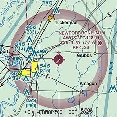
|
| Airport distance calculator |
|---|
|
|
| Sunrise and sunset |
|---|
|
Times for 27-Oct-2025
| | Local
(UTC-5) | | Zulu
(UTC) |
|---|
| Morning civil twilight | | 06:57 | | 11:57 |
| Sunrise | | 07:23 | | 12:23 |
| Sunset | | 18:14 | | 23:14 |
| Evening civil twilight | | 18:40 | | 23:40 |
|
| Current date and time |
|---|
| Zulu (UTC) | 27-Oct-2025 05:27:31 |
|---|
| Local (UTC-5) | 27-Oct-2025 00:27:31 |
|---|
|
| METAR |
|---|
| KM19 | 270522Z AUTO 35006KT 2SM BR OVC004 13/12 A3000 RMK AO2 $
|
|
| TAF |
|---|
KJBR
28nm NE | 261728Z 2618/2718 10011KT 6SM -SHRA OVC012 TEMPO 2618/2621 4SM SHRA OVC009 FM262100 08008KT 5SM -SHRA BR OVC007 FM270700 06006KT 5SM -DZ BR OVC004
|
|
| NOTAMs |
|---|
NOTAMs are issued by the DoD/FAA and will open in a separate window not controlled by AirNav.
|
|

