FAA INFORMATION EFFECTIVE 09 JULY 2026
Location
| FAA Identifier: | M23 |
| Lat/Long: | 32-18-43.2250N 089-08-08.3400W
32-18.720417N 089-08.139000W
32.3120069,-89.1356500
(estimated) |
| Elevation: | 370 ft. / 113 m (estimated) |
| Variation: | 02E (1985) |
| From city: | 1 mile SE of NEWTON, MS |
| Time zone: | UTC -5 (UTC -6 during Standard Time) |
| Zip code: | 39345 |
Airport Operations
| Airport use: | Open to the public |
| Activation date: | 04/1940 |
| Control tower: | no |
| ARTCC: | MEMPHIS CENTER |
| FSS: | GREENWOOD FLIGHT SERVICE STATION |
| NOTAMs facility: | GWO (NOTAM-D service available) |
| Attendance: | /ON CALL/
CALL 601-357-0213.
FOR ATTENDANT AFT HRS & EMERG ONLY CALL 601-357-0213. |
| Wind indicator: | lighted |
| Segmented circle: | yes |
| Lights: | ACTVT MIRL RWY 14/32 - CTAF. PAPI RWY 32 OPR CONSLY. |
| Beacon: | white-green (lighted land airport)
Operates sunset to sunrise. |
Airport Communications
| CTAF/UNICOM: | 122.8 |
| WX ASOS at MEI (20 nm E): | PHONE 601-207-0082 |
Nearby radio navigation aids
| VOR radial/distance | | VOR name | | Freq | | Var |
|---|
| MEIr252/17.3 | | MERIDIAN VORTAC | | 117.00 | | 05E |
Airport Services
| Fuel available: | 100LL
100LL:24 HR FUEL AVBL WITH CREDIT CARD. |
| Parking: | tiedowns |
| Airframe service: | MAJOR
TO SKED, CALL 601-357-0115; ALSO FOR PWR PLANT RPRS. |
| Powerplant service: | MAJOR |
| Bottled oxygen: | NONE |
| Bulk oxygen: | NONE |
Runway Information
Runway 14/32
| Dimensions: | 3000 x 75 ft. / 914 x 23 m |
| Surface: | asphalt, in good condition |
| Weight bearing capacity: | |
| Runway edge lights: | medium intensity |
| Runway edge markings: | MKGS FADED. |
| RUNWAY 14 | | RUNWAY 32 |
| Latitude: | 32-18.894333N | | 32-18.546500N |
| Longitude: | 089-08.346000W | | 089-07.932000W |
| Elevation: | 370.0 ft. | | 353.0 ft. |
| Traffic pattern: | left | | left |
| Runway heading: | 133 magnetic, 135 true | | 313 magnetic, 315 true |
| Markings: | basic, in poor condition | | basic, in poor condition |
| Visual slope indicator: | pulsating/steady burning VASI on left | | pulsating/steady burning VASI on left (7.00 degrees glide path) |
| Touchdown point: | yes, no lights | | yes, no lights |
| Obstructions: | 68 ft. trees, 900 ft. from runway, 200 ft. right of centerline, 10:1 slope to clear | | 109 ft. trees, 2600 ft. from runway, 300 ft. right of centerline, 22:1 slope to clear |
Airport Ownership and Management from official FAA records
| Ownership: | Publicly-owned |
| Owner: | TOWN OF NEWTON
PO BOX 300
NEWTON, MS 39345
Phone 601-282-0828
THE HONORABLE JAY POWELL, MAYOR OF NEWTON. |
| Manager: | HOOPER WEEMS
PO BOX 300
NEWTON, MS 39345
Phone 601-357-0213 |
Additional Remarks
| - | FOR CD CTC MERIDIAN APCH 601-679-3691, WHEN MERIDIAN APCH CLSD CTC MEMPHIS ARTCC AT 901-368-8453/8449. |
| - | COURTESY CAR AVBL. |
Instrument Procedures
There are no published instrument procedures at M23.
Some nearby airports with instrument procedures:
KMEI - Key Field Airport (20 nm E)
KMPE - Philadelphia Municipal Airport (29 nm N)
KNMM - Meridian Naval Air Station (Mc Cain Field) Airport (33 nm NE)
KNJW - Joe Williams Naval Outlying Field (33 nm NE)
KLUL - Hesler Airport/Noble Field (38 nm S)
|
|

Road maps at:
MapQuest
Bing
Google
| Aerial photo |
|---|
WARNING: Photo may not be current or correct

Do you have a better or more recent aerial photo of James H Easom Field Airport that you would like to share? If so, please send us your photo.
|
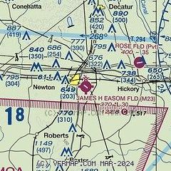
| Sectional chart |
|---|
|
| Airport distance calculator |
|---|
|
|
| Sunrise and sunset |
|---|
|
Times for 19-Jul-2026
| | Local
(UTC-5) | | Zulu
(UTC) |
|---|
| Morning civil twilight | | 05:36 | | 10:36 |
| Sunrise | | 06:04 | | 11:04 |
| Sunset | | 20:02 | | 01:02 |
| Evening civil twilight | | 20:29 | | 01:29 |
|
| Current date and time |
|---|
| Zulu (UTC) | 19-Jul-2026 19:54:47 |
|---|
| Local (UTC-5) | 19-Jul-2026 14:54:47 |
|---|
|
| METAR |
|---|
KMEI
20nm E | 191858Z 30008KT 10SM CLR 34/23 A2995 RMK AO2 SLP136 T03440233 $
|
KMPE
29nm N | 191935Z AUTO 33006KT 4SM HZ 34/24 A2994 RMK AO2
|
KNMM
32nm NE | 191856Z VRB03KT 10SM FEW050 BKN095 34/22 A2995 RMK AO2 SLP147 T03390222 $
|
KNJW
33nm NE | 191857Z AUTO 28008KT 10SM FEW044 33/24 A2999 RMK AO2 SLP068 T03330239
|
|
| TAF |
|---|
KMEI
20nm E | 191723Z 1918/2018 34005KT P6SM FEW110
|
|
| NOTAMs |
|---|
NOTAMs are issued by the DoD/FAA and will open in a separate window not controlled by AirNav.
|
|

