FAA INFORMATION EFFECTIVE 11 JUNE 2026
Location
| FAA Identifier: | MHP |
| Lat/Long: | 32-22-26.3000N 082-04-53.2000W
32-22.438333N 082-04.886667W
32.3739722,-82.0814444
(estimated) |
| Elevation: | 197.3 ft. / 60.1 m (surveyed) |
| Variation: | 07W (2020) |
| From city: | 2 miles S of METTER, GA |
| Time zone: | UTC -4 (UTC -5 during Standard Time) |
| Zip code: | 30439 |
Airport Operations
| Airport use: | Open to the public |
| Activation date: | 09/1963 |
| Control tower: | no |
| ARTCC: | JACKSONVILLE CENTER |
| FSS: | MACON FLIGHT SERVICE STATION |
| NOTAMs facility: | MCN (NOTAM-D service available) |
| Attendance: | UNATTENDED |
| Wind indicator: | lighted |
| Segmented circle: | yes |
| Lights: | ACTVT PAPI RWY 10 & 28; REIL RWY 10; MIRL RWY 10/28 - CTAF. |
| Beacon: | white-green (lighted land airport)
Operates sunset to sunrise. |
Airport Communications
| CTAF/UNICOM: | 123.0 |
| WX AWOS-3PT: | 120.3 (912-685-2729) |
| WX AWOS-3 at CWV (15 nm SE): | 120.075 (912-739-3768) |
| WX AWOS-3 at VDI (18 nm SW): | 119.925 (912-538-0219) |
| WX AWOS-3 at TBR (19 nm E): | 119.025 (912-764-9321) |
| WX AWOS-3PT at RVJ (19 nm S): | 128.325 (912-557-0011) |
- APCH/DEP SVC PRVDD BY JACKSONVILLE ARTCC ON FREQS 132.925/363.2 (MILLEN RCAG).
Nearby radio navigation aids
| VOR radial/distance | | VOR name | | Freq | | Var |
|---|
| DBNr112/39.6 | | DUBLIN VORTAC | | 113.10 | | 05W |
| NDB name | | Hdg/Dist | | Freq | | Var | | ID |
|---|
| ONYUN | | 057/14.2 | | 372 | | 06W | | UQN | ..- --.- -. |
| BULLO | | 268/21.3 | | 407 | | 05W | | BZQ | -... --.. --.- |
Airport Services
| Fuel available: | 100LL JET-A+ |
| Parking: | tiedowns |
| Airframe service: | MAJOR |
| Powerplant service: | MAJOR |
| Bottled oxygen: | NONE |
| Bulk oxygen: | NONE |
Runway Information
Runway 10/28
| Dimensions: | 5001 x 75 ft. / 1524 x 23 m |
| Surface: | asphalt, in good condition |
| Weight bearing capacity: | |
| Runway edge lights: | medium intensity |
| RUNWAY 10 | | RUNWAY 28 |
| Latitude: | 32-22.458092N | | 32-22.419348N |
| Longitude: | 082-05.371248W | | 082-04.400472W |
| Elevation: | 188.0 ft. | | 195.9 ft. |
| Traffic pattern: | left | | left |
| Runway heading: | 100 magnetic, 093 true | | 280 magnetic, 273 true |
| Markings: | nonprecision, in fair condition | | nonprecision, in fair condition |
| Visual slope indicator: | 2-light PAPI on right (3.00 degrees glide path) | | 2-light PAPI on left (3.00 degrees glide path) |
| Runway end identifier lights: | yes | | |
| Touchdown point: | yes, no lights | | yes, no lights |
| Obstructions: | 81 ft. trees, 2565 ft. from runway, 575 ft. left of centerline, 29:1 slope to clear | | 14 ft. road, 442 ft. from runway, 286 ft. right of centerline, 17:1 slope to clear
6 FT FENCE AND SHRUBS 0 FT-200 FT FM THR, 180 FT RIGHT. |
Airport Ownership and Management from official FAA records
| Ownership: | Publicly-owned |
| Owner: | METTER-CANDLER AIRPORT AUTHORITY
PO BOX 61
METTER, GA 30439
Phone 912-685-7845 |
| Manager: | CLIFF HENDRIX
METTER-CANDLER AIRPORT AUTHORITY, 25 S. TERRELL STREET
METTER, GA 30439
Phone 912-536-5909
ARPT PHONE 912-685-4162. |
Additional Remarks
| - | FOR CD CTC JACKSONVILLE ARTCC AT 904-845-1592. |
Instrument Procedures
NOTE: All procedures below are presented as PDF files. If you need a reader for these files, you should download the free Adobe Reader.NOT FOR NAVIGATION. Please procure official charts for flight.
FAA instrument procedures published for use from 11 June 2026 at 0901Z to 09 July 2026 at 0900z.
IAPs - Instrument Approach Procedures |
|---|
| RNAV (GPS) RWY 10 | |
download (222KB) |
| RNAV (GPS) RWY 28 | |
download (221KB) |
| NOTE: Special Alternate Minimums apply | |
download (158KB) |
| NOTE: Special Take-Off Minimums/Departure Procedures apply | |
download (480KB) |
Other nearby airports with instrument procedures:
KCWV - Claxton-Evans County Airport (15 nm SE)
KVDI - Vidalia Regional Airport (18 nm SW)
KTBR - Statesboro-Bulloch County Airport (19 nm E)
KRVJ - Swinton Smith Field at Reidsville Municipal Airport (19 nm S)
KSBO - East Georgia Regional Airport (20 nm NW)
|
|

Road maps at:
MapQuest
Bing
Google
| Aerial photo |
|---|
WARNING: Photo may not be current or correct

Do you have a better or more recent aerial photo of John Edwin Jones Sr Field/Metter Municipal Airport that you would like to share? If so, please send us your photo.
|
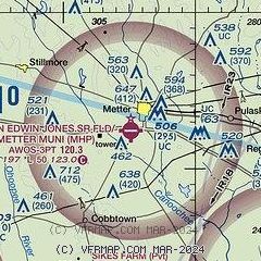
| Sectional chart |
|---|
|
| Airport distance calculator |
|---|
|
|
| Sunrise and sunset |
|---|
|
Times for 14-Jun-2026
| | Local
(UTC-4) | | Zulu
(UTC) |
|---|
| Morning civil twilight | | 05:53 | | 09:53 |
| Sunrise | | 06:22 | | 10:22 |
| Sunset | | 20:35 | | 00:35 |
| Evening civil twilight | | 21:04 | | 01:04 |
|
| Current date and time |
|---|
| Zulu (UTC) | 14-Jun-2026 18:40:31 |
|---|
| Local (UTC-4) | 14-Jun-2026 14:40:31 |
|---|
|
| METAR |
|---|
| KMHP | 141815Z AUTO 20005KT 10SM SCT120 33/23 A2992 RMK AO2 LTG DSNT N SE AND S T03320235
|
KCWV
15nm SE | 141815Z AUTO 18007G16KT 140V210 1SM VCTS RA BR BKN004 BKN039 BKN085 23/23 A2994 RMK AO2 PK WND 26041/58 LTG DSNT ALQDS PRESRR VIS M1/4V4
|
KVDI
18nm SW | 141815Z AUTO 23013G17KT 10SM FEW048 SCT055 SCT075 35/23 A2992 RMK AO2 LTG DSNT N AND E AND S
|
KTBR
19nm E | 141815Z AUTO 25008KT 10SM CLR 35/23 A2990 RMK AO2 LTG DSNT SE AND S AND NW
|
KRVJ
19nm S | 141755Z AUTO 01003KT 10SM TS SCT043 BKN060 BKN085 29/22 A2994 RMK AO2 LTG DSNT ALQDS T02870219 10349 20247
|
|
| TAF |
|---|
KSAV
47nm E | 141720Z 1418/1518 22007KT P6SM VCSH BKN040 BKN070 TEMPO 1418/1422 4SM TSRA SCT035CB BKN060 FM150000 21010KT P6SM BKN070 FM150600 24006KT P6SM FEW070 FM151300 29012KT P6SM SCT050 BKN060
|
|
| NOTAMs |
|---|
NOTAMs are issued by the DoD/FAA and will open in a separate window not controlled by AirNav.
|
|


