FAA INFORMATION EFFECTIVE 12 JUNE 2025
Location
| FAA Identifier: | P34 |
| Lat/Long: | 40-35-56.2000N 077-24-20.4000W
40-35.936667N 077-24.340000W
40.5989444,-77.4056667
(estimated) |
| Elevation: | 545 ft. / 166 m (estimated) |
| Variation: | 11W (2005) |
| From city: | 2 miles N of MIFFLINTOWN, PA |
| Time zone: | UTC -4 (UTC -5 during Standard Time) |
| Zip code: | 17059 |
Airport Operations
| Airport use: | Open to the public |
| Activation date: | 02/1977 |
| Control tower: | no |
| ARTCC: | NEW YORK CENTER |
| FSS: | WILLIAMSPORT FLIGHT SERVICE STATION |
| NOTAMs facility: | IPT (NOTAM-D service available) |
| Attendance: | UNATNDD |
| Wind indicator: | lighted |
| Segmented circle: | no |
| Lights: | ACTVT LIRL 08/26, WDI LGTS - CTAF. |
| Beacon: | white-green (lighted land airport)
ACTVT ROTG BCN - CTAF. |
Airport Communications
| CTAF/UNICOM: | 122.8 |
| WX AWOS-3PT at RVL (11 nm NW): | 123.85 (717-667-3993) |
- APCH/DEP SVC PRVDD BY ZNY ARTCC ON 134.8/338.3 (PHILIPSBURG RCAG).
Nearby radio navigation aids
| VOR radial/distance | | VOR name | | Freq | | Var |
|---|
| HARr329/23.5 | | HARRISBURG VORTAC | | 115.35 | | 10W |
| SEGr252/26.4 | | SELINSGROVE VOR/DME | | 110.40 | | 08W |
| PSBr136/32.8 | | PHILIPSBURG VORTAC | | 115.50 | | 10W |
| RAVr285/36.8 | | RAVINE VORTAC | | 114.60 | | 11W |
Airport Services
| Parking: | hangars |
| Airframe service: | NONE |
| Powerplant service: | NONE |
Runway Information
Runway 8/26
| Dimensions: | 2627 x 50 ft. / 801 x 15 m |
| Surface: | asphalt, in good condition |
| Runway edge lights: | low intensity |
| Runway edge markings: | RWY NOT MKD FOR NPI APCH. |
| RUNWAY 8 | | RUNWAY 26 |
| Latitude: | 40-35.850000N | | 40-36.023333N |
| Longitude: | 077-24.600000W | | 077-24.080000W |
| Elevation: | 543.5 ft. | | 540.0 ft. |
| Traffic pattern: | left | | left |
| Displaced threshold: | 232 ft. | | no |
| Markings: | basic, in good condition | | NSTD, in good condition |
| Touchdown point: | yes, no lights | | yes, no lights |
| Obstructions: | 42 ft. trees, 214 ft. from runway, 243 ft. right of centerline
RWY 08 HAS 20-50 FT HIGH TREES 150 FT FM RWY END TO 430 FT BHND RWY END, 60-170 FT L OF CNTRLN; 20-40 FT HIGH STRUCTURES & TREES 50 FT FM RWY END TO 530 FT BHND RWY END, 90-160 FT R OF CNTRLN. | | 29 ft. trees, 672 ft. from runway, 143 ft. right of centerline, 16:1 slope to clear |
Airport Ownership and Management from official FAA records
| Ownership: | Privately-owned |
| Owner: | MIFFLINTOWN AIRPARK LLC
600 AIRPORT DR.
MIFFLINTOWN, PA 17059
Phone 717-436-2725 |
| Manager: | BRUCE LISLE
600 AIRPORT DR.
MIFFLINTOWN, PA 17059
Phone 717-436-2725 |
Additional Remarks
| - | FOR CD CTC NEW YORK ARTCC AT 631-468-1425. |
Instrument Procedures
NOTE: All procedures below are presented as PDF files. If you need a reader for these files, you should download the free Adobe Reader.NOT FOR NAVIGATION. Please procure official charts for flight.
FAA instrument procedures published for use from 12 June 2025 at 0901Z to 10 July 2025 at 0900z.
IAPs - Instrument Approach Procedures |
|---|
| RNAV (GPS) RWY 26 | |
download (220KB) |
Departure Procedures |
|---|
| WOBKA TWO (RNAV) | |
download (106KB) |
| NOTE: Special Take-Off Minimums/Departure Procedures apply | |
download (149KB) |
Other nearby airports with instrument procedures:
KRVL - Mifflin County Airport (11 nm NW)
KUNV - State College Regional Airport (25 nm NW)
N96 - Bellefonte Airport (25 nm NW)
N94 - Carlisle Airport (27 nm SE)
KSEG - Penn Valley Airport (28 nm NE)
|
|

Road maps at:
MapQuest
Bing
Google
| Aerial photo |
|---|
WARNING: Photo may not be current or correct
 Photo by John F. Faust
Photo taken 18-Mar-2010
Photo by John F. Faust
Photo taken 18-Mar-2010
Do you have a better or more recent aerial photo of Mifflintown Airport that you would like to share? If so, please send us your photo.
|
| Sectional chart |
|---|
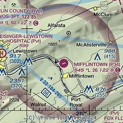
|
| Airport distance calculator |
|---|
|
|
| Sunrise and sunset |
|---|
|
Times for 26-Jun-2025
| | Local
(UTC-4) | | Zulu
(UTC) |
|---|
| Morning civil twilight | | 05:08 | | 09:08 |
| Sunrise | | 05:41 | | 09:41 |
| Sunset | | 20:43 | | 00:43 |
| Evening civil twilight | | 21:17 | | 01:17 |
|
| Current date and time |
|---|
| Zulu (UTC) | 27-Jun-2025 01:55:47 |
|---|
| Local (UTC-4) | 26-Jun-2025 21:55:47 |
|---|
|
| METAR |
|---|
KRVL
11nm NW | 270135Z AUTO 00000KT 10SM CLR 25/22 A3005 RMK AO2
|
|
| TAF |
|---|
KUNV
25nm NW | 262127Z 2621/2718 28007KT P6SM SCT050 FM262300 30015KT 3SM -TSRA BR OVC020CB FM270100 VRB03KT P6SM FEW050 FM270600 08003KT 5SM BR OVC010
|
|
| NOTAMs |
|---|
NOTAMs are issued by the DoD/FAA and will open in a separate window not controlled by AirNav.
|
|


