FAA INFORMATION EFFECTIVE 02 OCTOBER 2025
Location
| FAA Identifier: | BET |
| Lat/Long: | 60-46-42.8000N 161-50-13.8000W
60-46.713333N 161-50.230000W
60.7785556,-161.8371667
(estimated) |
| Elevation: | 128.8 ft. / 39.3 m (surveyed) |
| Variation: | 11E (2020) |
| From city: | 3 miles SW of BETHEL, AK |
| Time zone: | UTC -8 (UTC -9 during Standard Time) |
| Zip code: | 99559 |
Airport Operations
| Airport use: | Open to the public |
| Activation date: | 11/1958 |
| Control tower: | yes |
| ARTCC: | ANCHORAGE CENTER |
| FSS: | KENAI FLIGHT SERVICE STATION [907-283-7211] |
| NOTAMs facility: | BET (NOTAM-D service available) |
| Attendance: | MAY-OCT MON-FRI 0700-2100, MAY-OCT SAT-SUN 0700-2200, NOV-APR MON-FRI 0500-2100, NOV-APR SAT-SUN 0700-2100 |
| Wind indicator: | lighted |
| Segmented circle: | yes |
| Lights: | WHEN ATCT CLSD ACTVT HIRL RWY 01L/19R, 01R/19L, RWY 12/30; TWY LIGHTS - CTAF. ACTVT MALSR RWY 01L & 19R; REIL RWY 01R & 19L; VASI RWY 01L & 19R; PAPI RWY 01R & 19L - CTAF. |
| Beacon: | white-green (lighted land airport)
Operates sunset to sunrise. |
| Fire and rescue: | ARFF index B |
| Airline operations: | CLSD TO ACR OPS MORE THAN 30 PAX SEATS OR APVD WRITTEN PPR - AMGR BOX 505, BETHEL, AK 99559. |
Airport Communications
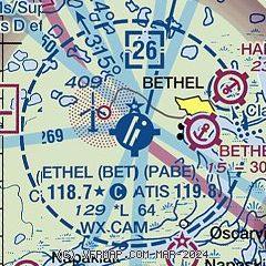
| CTAF: | 118.7 |
| ATIS: | 119.8 |
| WX ASOS: | 135.45 (907-560-7632) |
| BETHEL GROUND: | 121.7 [0700-2200 1 APR - 31 OCT; 0700-2000 1 NOV - 31 MAR.] |
| BETHEL TOWER: | 118.7 [0700-2200 1 APR - 31 OCT; 0700-2000 1 NOV - 31 MAR.] |
| EMERG: | 121.5 |
| WX AWOS-3P at WNA (7 nm SW): | 121.425 (907-868-7317) |
| WX AWOS-3P at KWT (12 nm E): | 120.000 (907-868-7313) |
| WX AWOS-3P at Z13 (13 nm NE): | 118.0 (907-269-2870) |
| WX AWOS-3P at 16A (19 nm NW): | 121.550 (907-868-7319) |
- APCH/DEP SVC PRVDD BY ANCHORAGE ARTCC ON FREQS 125.2/372.0 (BETHEL RCAG).
- FREQ 118.7 IS CTAF AT BETHEL SPB AND HANGAR LAKE SPB.
Nearby radio navigation aids
| VOR radial/distance | | VOR name | | Freq | | Var |
|---|
| BET at field | | BETHEL VORTAC | | 114.10 | | 14E |
| NDB name | | Hdg/Dist | | Freq | | Var | | ID |
|---|
| OSCARVILLE | | 115/1.3 | | 251 | | 11E | | OSE | --- ... . |
Airport Services
| Fuel available: | 100 100LL JET-A JET-A1
100:SELF VC FUEL NA; FEE AFT 1800. |
| Parking: | hangars and tiedowns |
| Airframe service: | MINOR |
| Powerplant service: | MINOR |
Runway Information
Runway 1L/19R
| Dimensions: | 6400 x 150 ft. / 1951 x 46 m |
| Surface: | asphalt/grooved, in good condition |
| Weight bearing capacity: | | Single wheel: | 120.0 | | Double wheel: | 190.0 | | Double tandem: | 281.0 |
|
| Runway edge lights: | high intensity |
| RUNWAY 1L | | RUNWAY 19R |
| Latitude: | 60-46.306147N | | 60-47.269648N |
| Longitude: | 161-50.610210W | | 161-49.754912W |
| Elevation: | 127.2 ft. | | 102.2 ft. |
| Traffic pattern: | left | | left |
| Runway heading: | 012 magnetic, 023 true | | 192 magnetic, 203 true |
| Declared distances: | TORA:6400 TODA:6400 ASDA:6400 LDA:6400 | | TORA:6400 TODA:6400 ASDA:6400 LDA:6400 |
| Markings: | precision, in fair condition | | precision, in fair condition |
| Visual slope indicator: | 4-box VASI on left (3.00 degrees glide path) | | 4-box VASI on left (3.00 degrees glide path) |
| RVR equipment: | touchdown
TOUCHDOWN RVR AVBL 0700-2000 1 NOV-30 MAR; 1 APR-31 OCT 0700-2200. | | touchdown
TOUCHDOWN RVR AVBL 0700-2000 1 NOV-30 MAR; 1 APR-31 OCT 0700-2200. |
| Approach lights: | MALSR: 1,400 foot medium intensity approach lighting system with runway alignment indicator lights | | MALSR: 1,400 foot medium intensity approach lighting system with runway alignment indicator lights |
| Runway end identifier lights: | no | | |
| Touchdown point: | yes, no lights | | yes, no lights |
| Instrument approach: | MLS | | ILS/DME |
Runway 1R/19L
| Dimensions: | 4000 x 75 ft. / 1219 x 23 m |
| Surface: | asphalt, in fair condition |
| Weight bearing capacity: | | Single wheel: | 90.0 | | Double wheel: | 134.0 | | Double tandem: | 203.0 |
|
| Runway edge lights: | high intensity |
| Operational restrictions: | RWY 01R/19L NOT AVBL FOR PART 121/380 SKED AND NON-SKED OPS WITH PAX CARRYING OPS MORE THAN 30 PAX SEATS. |
| RUNWAY 1R | | RUNWAY 19L |
| Latitude: | 60-46.260398N | | 60-46.862523N |
| Longitude: | 161-50.395015W | | 161-49.860332W |
| Elevation: | 122.1 ft. | | 116.8 ft. |
| Traffic pattern: | left | | left |
| Runway heading: | 012 magnetic, 023 true | | 192 magnetic, 203 true |
| Markings: | nonprecision, in good condition | | nonprecision, in good condition |
| Visual slope indicator: | 4-light PAPI on left (3.00 degrees glide path) | | 4-light PAPI on left (3.00 degrees glide path) |
| Runway end identifier lights: | yes | | yes |
| Touchdown point: | yes, no lights | | yes, no lights |
Runway 12/30
| Dimensions: | 1858 x 75 ft. / 566 x 23 m |
| Surface: | gravel, in good condition
495 FT ASPH RWY 30 END; RMNG GRVL. |
| Weight bearing capacity: | |
| Runway edge lights: | high intensity |
| Operational restrictions: | RWY 12/30 NOT AVBL FOR PART 121/PART 380 OPS WITH SKED PAX CARRYING OPS MORE THAN 9 PAX SEATS AND NON-SKED PAX CARRYING OPS MORE THAN 30 PAX SEATS. W 1200 FT CLSD OVR 12500 LBS GWT APR-NOV. |
| RUNWAY 12 | | RUNWAY 30 |
| Latitude: | 60-46.878963N | | 60-46.689027N |
| Longitude: | 161-50.860840W | | 161-50.372993W |
| Elevation: | 125.6 ft. | | 126.8 ft. |
| Traffic pattern: | left | | left |
| Runway heading: | 117 magnetic, 128 true | | 297 magnetic, 308 true |
| Runway end identifier lights: | no | | no |
| Touchdown point: | yes, no lights | | yes, no lights |
Airport Ownership and Management from official FAA records
| Ownership: | Publicly-owned |
| Owner: | ALASKA DOT&PF CENTRAL REGION
PO BOX 196900
ANCHORAGE, AK 99519-6900
Phone 907-269-0749 |
| Manager: | NICK NORWOOD
BOX 505
BETHEL, AK 99559
Phone 907-543-2498 |
Additional Remarks
| A39-01L/19R | PCR VALUE: 514/F/C/X/T |
| A39-01R/19L | PCR VALUE: 361/F/C/X/T |
| - | WX CAMERA AVBL ON INTERNET AT HTTPS://WEATHERCAMS.FAA.GOV. |
| - | TSNT PRKG W END OF S RAMP MRKD BY GREEN CONES. |
| - | COND RPRTG & OTR MAINT SVC AVBL DURG MAINT DUTY HR. AFT HR SVC PPR IN WRITING - AMGR. |
| - | NWS BLN LAUNCH FAC ON ARPT - SEE INSIDE BACK CVR FOR OPS DTLS. |
| - | LOCK WHEEL TURNS NA ALL SFCS. |
| - | TSA REG; SEE 49 CFR 1542. GATES & DOORS SECURED ALL TIMES. UNFAM TSNT - AMGR. |
| - | ARPT SAND SMALLER GRADATION THAN FAA RCMDD/SEE AC150/5200-30. |
| - | PAEW MAY BE ON RWYS. |
| - | PTARMIGAN & WATERFOWL INVOF ARPT. |
Instrument Procedures
NOTE: All procedures below are presented as PDF files. If you need a reader for these files, you should download the free Adobe Reader.NOT FOR NAVIGATION. Please procure official charts for flight.
FAA instrument procedures published for use from 02 October 2025 at 0901Z to 30 October 2025 at 0900z.
IAPs - Instrument Approach Procedures |
|---|
| ILS Y OR LOC Y RWY 19R | |
download (270KB) |
| ILS Y OR LOC Y RWY 19R | |
download (270KB) |
| ILS Z OR LOC Z RWY 19R | |
download (247KB) |
| ILS Z OR LOC Z RWY 19R | |
download (247KB) |
| RNAV (GPS) RWY 01L | |
download (297KB) |
| RNAV (GPS) RWY 01R | |
download (255KB) |
| RNAV (GPS) RWY 19L | |
download (249KB) |
| RNAV (GPS) RWY 19R | |
download (245KB) |
| RNAV (GPS)-A | |
download (173KB) |
| VOR RWY 01L | |
download (238KB) |
| VOR RWY 01L | |
download (238KB) |
| NOTE: Special Alternate Minimums apply | |
download (153KB) |
| NOTE: Special Take-Off Minimums/Departure Procedures apply | |
download (265KB) |
Other nearby airports with instrument procedures:
PAPK - Napaskiak Airport (5 nm S)
PANA - Napakiak Airport (7 nm SW)
PFKW - Kwethluk Airport (12 nm E)
PFZK - Akiachak Airport (13 nm NE)
PFAK - Akiak Airport (19 nm NE)
|
|

Road maps at:
MapQuest
Bing
Google
| Aerial photo |
|---|
WARNING: Photo may not be current or correct
 Photo courtesy of Craig Boney @ Skylane Photo
Taken in September 2007
Photo courtesy of Craig Boney @ Skylane Photo
Taken in September 2007
Do you have a better or more recent aerial photo of Bethel Airport that you would like to share? If so, please send us your photo.
|
| Sectional chart |
|---|
|
| Airport distance calculator |
|---|
|
|
| Sunrise and sunset |
|---|
|
Times for 22-Oct-2025
| | Local
(UTC-8) | | Zulu
(UTC) |
|---|
| Morning civil twilight | | 09:04 | | 17:04 |
| Sunrise | | 09:48 | | 17:48 |
| Sunset | | 19:15 | | 03:15 |
| Evening civil twilight | | 20:00 | | 04:00 |
|
| Current date and time |
|---|
| Zulu (UTC) | 22-Oct-2025 23:40:15 |
|---|
| Local (UTC-8) | 22-Oct-2025 15:40:15 |
|---|
|
| METAR |
|---|
| PABE | 222253Z 33017KT 10SM OVC022 M02/M05 A2908 RMK AO2 SLP850 T10171050
|
PANA
7nm SW | 222256Z AUTO 34014G18KT 10SM OVC022 M02/M04 A2908 RMK AO2 SNB35E46 SLP848 P0000 T10171044 FZRANO TSNO
|
PFKW
12nm E | 222256Z AUTO 34011KT 10SM OVC020 M02/M05 A2907 RMK AO2 SLP844 T10221050 FZRANO PNO $
|
PFZK
13nm NE | 222256Z AUTO 34012KT 10SM OVC021 A2906 RMK AO2 SLPNO FZRANO $
|
PPIT
19nm NW | 222256Z AUTO 35017G24KT 10SM BKN021 OVC029 M01/M04 A2910 RMK AO2 SLP855 T10111044 FZRANO
|
|
| TAF |
|---|
| PABE | 221732Z 2218/2318 35016G25KT P6SM SCT015 OVC025 FM222200 35017KT 4SM -SN BR OVC010 FM230600 34016KT 3SM -SN BR OVC008 FM231200 32012KT 4SM -SN BR SCT008 OVC015
|
|
| NOTAMs |
|---|
NOTAMs are issued by the DoD/FAA and will open in a separate window not controlled by AirNav.
|
|

