FAA INFORMATION EFFECTIVE 16 APRIL 2026
Location
| FAA Identifier: | MDO |
| Lat/Long: | 59-26-59.7970N 146-18-26.0660W
59-26.996617N 146-18.434433W
59.4499436,-146.3072406
(estimated) |
| Elevation: | 100.4 ft. / 30.6 m (surveyed) |
| Variation: | 18E (2015) |
| From city: | 1 mile S of MIDDLETON ISLAND, AK |
| Time zone: | UTC -8 (UTC -9 during Standard Time) |
Airport Operations
| Airport use: | Open to the public |
| Activation date: | 01/1949 |
| Control tower: | no |
| ARTCC: | ANCHORAGE CENTER |
| FSS: | JUNEAU FLIGHT SERVICE STATION [907-586-7380] |
| NOTAMs facility: | MDO (NOTAM-D service available) |
| Attendance: | UNATNDD |
| Wind indicator: | yes |
| Segmented circle: | no |
Airport Communications
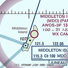
| CTAF: | 122.9 |
| WX AWOS-3P: | 135.725 (907-269-2855) |
- APCH/DEP SVC PRVDD BY ANCHORAGE ARTCC ON FREQ 133.6/269.4 (MIDDLETON ISLAND RCAG).
- COMMUNICATIONS PRVDD BY JUNEAU FSS ON FREQ 122.05 (MIDDLETON ISLAND RCO).
Nearby radio navigation aids
| VOR radial/distance | | VOR name | | Freq | | Var |
|---|
| MDOr020/2.1 | | MIDDLETON ISLAND VOR/DME | | 115.30 | | 18E |
Airport Services
Runway Information
Runway 2/20
| Dimensions: | 3158 x 115 ft. / 963 x 35 m |
| Surface: | gravel, in good condition |
| Runway edge markings: | CONES. |
| Operational restrictions: | DOWN SLOPE TO S. SAFETY AREAS SOFT. |
| RUNWAY 2 | | RUNWAY 20 |
| Latitude: | 59-26.652518N | | 59-27.080685N |
| Longitude: | 146-18.771130W | | 146-18.197412W |
| Elevation: | 100.1 ft. | | 100.4 ft. |
| Traffic pattern: | left | | left |
| Runway heading: | 016 magnetic, 034 true | | 196 magnetic, 214 true |
| Markings: | , in poor condition | | , in poor condition |
| Touchdown point: | yes, no lights | | yes, no lights |
| Obstructions: | 15 ft. road, 94 ft. left of centerline | | 15 ft. road, 84 ft. right of centerline |
Runway 13/31
| Dimensions: | 1500 x 125 ft. / 457 x 38 m |
| Surface: | turf/dirt/L |
| Runway edge markings: | CONES. |
| Operational restrictions: | CLSD INDEFLY. MAINT NA. GRASS & ROCKS ON RWY. |
| RUNWAY 13 | | RUNWAY 31 |
| Latitude: | 59-27.376567N | | 59-27.163912N |
| Longitude: | 146-18.451552W | | 146-18.207555W |
| Elevation: | 98.9 ft. | | 96.8 ft. |
| Traffic pattern: | left | | left |
| Runway heading: | 131 magnetic, 149 true | | 311 magnetic, 329 true |
| Touchdown point: | yes, no lights | | yes, no lights |
| Obstructions: | 15 ft. road, 74 ft. right of centerline | | 15 ft. road, 90 ft. left of centerline |
Airport Ownership and Management from official FAA records
| Ownership: | Publicly-owned |
| Owner: | FAA-KENAI SUPPORT CENTER
427 N. WILLOW ST.
KENAI, AK 99611
Phone 907-283-4526 |
| Manager: | US GOV, FAA KENAI SSC
427 N. WILLOW ST.
KENAI, AK 99611
Phone 907-283-4526 |
Additional Remarks
| A30A-31 | 2 FT BRUSH APCH END. |
| A30A-02 | CTN: EAGLE NEST ON APCH. ELEC TRANSFORMER WI SAFETY AREA APCH END. |
| - | WX CAMERA ON RWY EDGE. WX CAMERA AVBL ON INTERNET AT HTTPS://WEATHERCAMS.FAA.GOV |
| - | WATERFOWL & WILDLIFE INVOF OF RWYS. |
Instrument Procedures
NOTE: All procedures below are presented as PDF files. If you need a reader for these files, you should download the free Adobe Reader.NOT FOR NAVIGATION. Please procure official charts for flight.
FAA instrument procedures published for use from 16 April 2026 at 0901Z to 14 May 2026 at 0900Z.
IAPs - Instrument Approach Procedures |
|---|
| RNAV (GPS) RWY 02 | |
download (191KB) |
| RNAV (GPS) RWY 20 | |
download (188KB) |
| VOR RWY 02 | |
download (181KB) |
| NOTE: Special Take-Off Minimums/Departure Procedures apply | |
download (148KB) |
Other nearby airports with instrument procedures:
PACV - Merle K (Mudhole) Smith Airport (67 nm N)
PAKA - Tatitlek Airport (86 nm N)
|
|

Road maps at:
MapQuest
Bing
Google
| Aerial photo |
|---|

|
| Sectional chart |
|---|
|
| Airport distance calculator |
|---|
|
|
| Sunrise and sunset |
|---|
|
Times for 01-May-2026
| | Local
(UTC-8) | | Zulu
(UTC) |
|---|
| Morning civil twilight | | 04:54 | | 12:54 |
| Sunrise | | 05:46 | | 13:46 |
| Sunset | | 21:39 | | 05:39 |
| Evening civil twilight | | 22:31 | | 06:31 |
|
| Current date and time |
|---|
| Zulu (UTC) | 02-May-2026 04:34:19 |
|---|
| Local (UTC-8) | 01-May-2026 20:34:19 |
|---|
|
| METAR |
|---|
| PAMD | 020413Z AUTO 13021G27KT 1 3/4SM -RA OVC003 A2966 RMK AO2 PK WND 13027/0407 P0003 FZRANO $
|
|
| NOTAMs |
|---|
NOTAMs are issued by the DoD/FAA and will open in a separate window not controlled by AirNav.
|
|

