FAA INFORMATION EFFECTIVE 04 SEPTEMBER 2025
Location
| FAA Identifier: | PBV |
| Lat/Long: | 56-34-38.5000N 169-39-49.4000W
56-34.641667N 169-39.823333W
56.5773611,-169.6637222
(estimated) |
| Elevation: | 127.9 ft. / 39.0 m (surveyed) |
| Variation: | 07E (2020) |
| From city: | 4 miles SW of ST GEORGE, AK |
| Time zone: | UTC -9 (UTC -10 during Standard Time) |
| Zip code: | 99591 |
Airport Operations
| Airport use: | Open to the public |
| Activation date: | 07/1992 |
| Control tower: | no |
| ARTCC: | ANCHORAGE OCEANIC CENTER |
| FSS: | KENAI FLIGHT SERVICE STATION [907-283-7211] |
| NOTAMs facility: | PBV (NOTAM-D service available) |
| Attendance: | UNATNDD |
| Wind indicator: | lighted |
| Segmented circle: | yes |
| Lights: | ACTVT HIRL RY 11/29, REIL RY 29; MALSF & PAPI RY 11, & WINDSOCK - CTAF. |
| Beacon: | white-green (lighted land airport)
ACTVT ROTG BCN - CTAF. |
Airport Communications
| CTAF: | 122.8 |
| WX ASOS: | 135.45 (907-560-7610) |
- APCH/DEP SVC PRVDD BY ANCHORAGE ARTCC ON FREQS 119.1/339.8 (SAINT PAUL ISLAND RCAG).
Nearby radio navigation aids
| NDB name | | Hdg/Dist | | Freq | | Var | | ID |
|---|
| PRIBILOF | | at field | | 399 | | 07E | | SRI | ... .-. .. |
| ST PAUL ISLAND | | 142/39.5 | | 314 | | 10E | | SPY | ... .--. -.-- |
Airport Services
Runway Information
Runway 11/29
| Dimensions: | 4982 x 150 ft. / 1519 x 46 m |
| Surface: | asphalt/grooved, in good condition |
| Runway edge lights: | high intensity |
| RUNWAY 11 | | RUNWAY 29 |
| Latitude: | 56-34.834875N | | 56-34.447235N |
| Longitude: | 169-40.476753W | | 169-39.171365W |
| Elevation: | 127.9 ft. | | 123.4 ft. |
| Traffic pattern: | right | | left |
| Runway heading: | 111 magnetic, 118 true | | 291 magnetic, 298 true |
| Markings: | precision, in fair condition | | precision, in fair condition |
| Visual slope indicator: | 4-light PAPI on left (3.60 degrees glide path) | | |
| Approach lights: | MALSF: 1,400 foot medium intensity approach lighting system with sequenced flashers | | |
| Runway end identifier lights: | | | yes |
| Touchdown point: | yes, no lights | | yes, no lights |
| Instrument approach: | LOC/GS | | |
| Obstructions: | 15 ft. road, 200 ft. from runway
ROAD BEGINNING AT EDGES OF THE END OF RWY EXTENDING OUT TO 200 FT MERGING APPX ON CENTERLINE. | | 35 ft. hill, 200 ft. from runway, 250 ft. right of centerline
ROAD BEGINNING AT RIGHT EDGE AND END OF RWY AND EXTENDS OUT TO 200 FT APPX PARALLEL TO RWY CENTERLINE. |
Airport Ownership and Management from official FAA records
| Ownership: | Publicly-owned |
| Owner: | ALASKA DOT&PF SOUTHCOAST REGION
PO BOX 112506
JUNEAU, AK 99811-2506
Phone (907) 465-1779 |
| Manager: | DALE RUCKMAN
PO BOX 920525
DUTCH HARBOR, AK 99692
Phone (907) 581-1786 |
Additional Remarks
| - | LARGE CONCENTRATIONS OF SEABIRDS INVOF ARPT. REINDEER AND FOX INVOF ARPT. |
| - | PILOTS ARE REQUESTED TO AVOID FLIGHTS BELOW 1000 FT AGL FROM MAY 14 THROUGH DEC 14 IN THOSE AREAS OF ST. GEORGE ISLAND WITH ACTIVE BIRD POPULATIONS AND COASTAL SEAL ROOKERIES. |
Instrument Procedures
NOTE: All procedures below are presented as PDF files. If you need a reader for these files, you should download the free Adobe Reader.NOT FOR NAVIGATION. Please procure official charts for flight.
FAA instrument procedures published for use from 04 September 2025 at 0901Z to 02 October 2025 at 0900z.
IAPs - Instrument Approach Procedures |
|---|
| ILS OR LOC RWY 11 | |
download (272KB) |
| RNAV (GPS) RWY 11 | |
download (238KB) |
| RNAV (GPS)-D | |
download (168KB) |
| NOTE: Special Alternate Minimums apply | |
download (62KB) |
| NOTE: Special Take-Off Minimums/Departure Procedures apply | |
download (210KB) |
Other nearby airports with instrument procedures:
PASN - St Paul Island Airport (40 nm NW)
|
|

Road maps at:
MapQuest
Bing
Google
| Aerial photo |
|---|
WARNING: Photo may not be current or correct
 Photo taken 07-Feb-2009
Do you have a better or more recent aerial photo of St George Airport that you would like to share? If so, please send us your photo.
|
| Sectional chart |
|---|
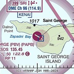
|
| Airport distance calculator |
|---|
|
|
| Sunrise and sunset |
|---|
|
Times for 01-Oct-2025
| | Local
(UTC-9) | | Zulu
(UTC) |
|---|
| Morning civil twilight | | 07:46 | | 16:46 |
| Sunrise | | 08:24 | | 17:24 |
| Sunset | | 19:53 | | 04:53 |
| Evening civil twilight | | 20:31 | | 05:31 |
|
| Current date and time |
|---|
| Zulu (UTC) | 01-Oct-2025 22:31:31 |
|---|
| Local (UTC-9) | 01-Oct-2025 13:31:31 |
|---|
|
| METAR |
|---|
| PAPB | 012153Z AUTO 29013KT 8SM FEW018 SCT025 SCT035 09/06 A2954 RMK AO2 PK WND 29026/2130 SLP992 T00890056 TSNO PNO $
|
|
| TAF |
|---|
PASN
39nm NW | 011720Z 0118/0218 25020KT P6SM SCT025 BKN035 FM012200 31020G30KT P6SM SCT025 BKN035 FM020600 21015G25KT P6SM SCT025 BKN035 FM021100 26020KT P6SM BKN100
|
|
| NOTAMs |
|---|
NOTAMs are issued by the DoD/FAA and will open in a separate window not controlled by AirNav.
|
|

