FAA INFORMATION EFFECTIVE 30 OCTOBER 2025
Location
| FAA Identifier: | NGF |
| Lat/Long: | 21-27-01.6400N 157-46-04.6150W
21-27.027333N 157-46.076917W
21.4504556,-157.7679486
(estimated) |
| Elevation: | 23 ft. / 7 m (estimated) |
| Variation: | 10E (1980) |
| From city: | 2 miles SW of KANEOHE, HI |
| Time zone: | UTC -10 (year round; does not observe DST) |
| Zip code: | 96734 |
Airport Operations
| Airport use: | Private use. Permission required prior to landing |
| Activation date: | 09/1946 |
| Control tower: | yes |
| ARTCC: | HONOLULU CONTROL FACILITY CENTER |
| FSS: | HONOLULU FLIGHT SERVICE STATION |
| NOTAMs facility: | PHNG (NOTAM-D service available) |
| Attendance: | ALL
OPR MON-THU 1730-1000Z; FRI 1730-0600Z; CLSD SAT, SUN AND HOL. OTH OPR HRS BY STRICT PPR APVL. OT CTC HONOLULU CTL FAC. |
| Segmented circle: | no |
| Lights: | RWY LGTS AVBL DUR OPR HR. |
| Beacon: | white-white-green (lighted military airport)
Operates sunset to sunrise. |
Airport Communications
| CTAF: | 120.7 |
| ATIS: | 284.5 |
| MARINE KANEOHE GROUND: | 382.8 [OPR MON-THU 1730-1000Z; FRI 1730-0600Z; CLSD SAT, SUN AND HOL. OT CTC HONOLULU CTL FAC.] |
| MARINE KANEOHE TOWER: | 120.7 360.2 342.6 [OPR MON-THU 1730-1000Z; FRI 1730-0600Z; CLSD SAT, SUN AND HOL. OT CTC HONOLULU CTL FAC.] |
| KANEOHE APPROACH: | 125.0 263.5 [OPR MON-THU 1730-1000Z; FRI 1730-0600Z; CLSD SAT, SUN AND HOL. OT CTC HONOLULU CTL FAC.] |
| KANEOHE DEPARTURE: | 125.0 263.5 [OPR MON-THU 1730-1000Z; FRI 1730-0600Z; CLSD SAT, SUN AND HOL. OT CTC HONOLULU CTL FAC.] |
| CLEARANCE DELIVERY: | 294.7 |
| EMERG: | 121.5 243.0 |
| PMSV METRO: | 344.6 |
| PTD: | 307.2 |
| WX ASOS at HNL (12 nm SW): | PHONE 808-836-0449 |
| WX ASOS at JRF (19 nm SW): | 119.8 (808-752-3876) |
- APCH/DEP SVC PRVDD BY HONOLULU CONTROL FACILITY (ZHN) ON FREQ 124.1/317.5 (MOUNT HALEAKALA RCAG) WHEN KANEOHE APCH CTL (NGF) CLSD.
Nearby radio navigation aids
| VOR radial/distance | | VOR name | | Freq | | Var |
|---|
| CKHr331/11.7 | | KOKO HEAD VORTAC | | 113.90 | | 11E |
| HNLr036/12.5 | | HONOLULU VORTAC | | 114.80 | | 11E |
| MKKr288/38.4 | | MOLOKAI VORTAC | | 116.10 | | 11E |
Airport Services
| Fuel available: | J5 (NATO CODE F-44) FUEL AVBL. |
| Bottled oxygen: | HIGH/LOW |
| Bulk oxygen: | HIGH/LOW |
Runway Information
Runway 4/22
| Dimensions: | 7771 x 200 ft. / 2369 x 61 m |
| Surface: | asphalt, in good condition |
| Weight bearing capacity: | |
| Runway edge lights: | high intensity |
| RUNWAY 4 | | RUNWAY 22 |
| Latitude: | 21-26.629000N
HORIZONTAL DATUM WGS84. | | 21-27.425667N
HORIZONTAL DATUM WGS84. |
| Longitude: | 157-46.614500W | | 157-45.539333W |
| Elevation: | 12.0 ft. | | 23.0 ft. |
| Traffic pattern: | left | | left |
| Runway heading: | 042 magnetic, 052 true | | 222 magnetic, 232 true |
| Markings: | nonprecision, in good condition | | precision, in good condition |
| Visual slope indicator: | 4-light PAPI on left (3.00 degrees glide path) | | 4-light PAPI on left (3.00 degrees glide path) |
| Approach lights: | SSALR: simplified short approach lighting system with runway alignment indicator lights | | SSALR: simplified short approach lighting system with runway alignment indicator lights |
| Runway end identifier lights: | yes | | yes |
| Touchdown point: | yes, no lights | | yes, no lights |
Airport Ownership and Management from official FAA records
| Ownership: | U.S. Navy |
| Owner: | US NAVY
OCEANOGRAPHIC OFC - CODE 3142
WASHINGTON, DC 20373 |
Additional Remarks
| - | SERVICE-LGT: RY 04 OLS; WAVE-OFF. |
| - | JASU - 2(MMG-1) (MMG-1A) 12(MMG-2) 2(NC-10A) (NCPP-105). |
| - | FUEL - J5, J8. |
| - | FLUID - LOX - TMU 27/70 RQR 24 HR PN. |
| - | OIL - O-128-132-133-156; SOAP AVBL PEARL HARBOR NS 1700-0130Z MON-FRI, OT PN RQR. |
| - | CSTMS/AG/IMG - ALL ACFT ARR OGNG OUTSIDE CONUS RQR MANDATORY CSTMS/AG/IMG/USDA INSPNS WITH 24 HR PN. ALL ACFT DEP TO CONUS RQR MANDATORY USDA INSPN. PHONE 3 HRS PRIOR TO ARR TO UPDATE CREW AND PAX INFO TO INCL FOREIGN NATL STS. ALL ACFT ARRS ARE RQRD TO NOTIFY AIR OPS OF ANYONE SUSPECTED OF ILLNESS PRIOR TO ARR TO K-BAY. FAILURE TO COMPLY WILL DELAY PAX DEBARKATION AND/OR POSS FINES. ACFT COMMANDER WILL COMPLY WITH ALL CSTMS/AG/IMG/USDA REGS. ALL MANDATED INSPNS ARRS COORD THRU VISITING ACFT LINE (VAL). FOR SKED USDA INSPNS CTC VAL ARR WITH PPSD DEP DATE/TIME, DSN 315-496-1604/1106 OR C808-496-1604/1106. |
| - | CAUTION - EXTV R/W TFC IN IMMED VCNTY NW OF RWY AT 500' AND BLW. BIRD HAZ. |
| - | TFC PAT - TSNT AIRCREW MUST OBTAIN CRS RULES BRIEFING PRIOR TO CONDUCTING OVHD BREAK; LCL ACFT ALT FIXED WING 1000 FT, ROTARY WING 500 FT. |
| - | MISC: RWY 22 GRAD FOR FIRST 2000 FT IS -0.3 PCT. VFR ACFT SEE SEC E FOR PREFERRED RTE. |
| - | RSTD 1 OF 3: ALL TSNT AND TENANT ACFT ARR/DEP OUTSIDE OF LOCAL FLYING AREA RQR A PPR. PPR WILL ONLY ISSUED DRG PUBLISHED OPR HRS. 48 HR NOTICE RQRD FOR ANY PPR CHG. CUSTOMS/AG/IMG RQR 24 HR ADVN NOTICE. |
| - | RSTD 2 OF 3: ACFT COMMANDERS ARE RESPONSIBLE FOR COORDG CHGS WITH FLT PLANNING AT DSN 315-496-2121/2122, C808-496-2121/2122. AFTER HRS CTC OPS DUTY OFFICER C808-348-4511. |
| - | RSTD 3 OF 3: ACFT CARRYING HAZUS CLASS 1.3 AND 1.4 MUNITIONS SHALL NOT EXCEED 50 LBS NET UNLESS SKEDD FOR COMBAT AIRCRAFT LOADING AREA (CALA) PRKG. CALA PRKG RQRD WILL BE CLEARLY IDENTIFIED ON PPR. |
| - | MISC: CLASS D ASP REVERTS TO CLASS E ASP WHEN TWR CLSD. CTC BASE OPS FOR ALL PPR REQS (OPR HRS, VAL REQS) AT DSN 315-496-2121/2122 OR C808-496-2121/2122 OR MCBH.ATC.SCHEDS.FMB@USMC.MIL. MIN 24 HR PN RQRD. PPR APVL ONLY DRG OPR HRS. REQ FONE PATCH 2 HRS PRIOR ARR. |
| - | RSTD: TWY T DSGND AS TOW WAY FROM TWY B TO FUEL PITS. TWY F DSGND AS TOW WAY FROM HEL RINSE TO COMPASS ROSE. |
| - | MISC - ALL CLSD ATCT AFLD OPS CAN ONLY BE APVD BY THE AFLD MGR. DSN 457-5551, C808-257-5551. *NOTE HEL/TILT ROTOR ONLY. |
| - | TRAN ALERT - OPR VISITING ACFT LINE (VAL) DUR AIRFIELD HRS. PPR ALWAYS RQR. LTD TRAN MAINT AVBL O/R. |
| - | CAUTION: ACTV ROADWAY XNG 5500 FT FROM RWY 04 THLD, 2267 FT FROM RWY 22 THLD. CLSD TWR FIXED WING OPS NOT AUTHD. CLSD TWR ROTARY WING OPS RQR AIRFIELD MGR APVL. DSN 457-5551, C808-257-5551. |
| E60-22 | 1612 FT FROM RY 22 |
| E60-04 | E28(B) (1680'). |
| E60-04 | 1680 FT FROM RY 04. |
Instrument Procedures
NOTE: All procedures below are presented as PDF files. If you need a reader for these files, you should download the free Adobe Reader.NOT FOR NAVIGATION. Please procure official charts for flight.
FAA instrument procedures published for use from 30 October 2025 at 0901Z to 27 November 2025 at 0900Z.
IAPs - Instrument Approach Procedures |
|---|
| RNAV (GPS) Y RWY 22 | |
download (150KB) |
| RNAV (GPS) Z RWY 22 | |
download (146KB) |
| HI-TACAN Y RWY 22 | |
download (179KB) |
| TACAN Z RWY 22 | |
download (154KB) |
| COPTER TACAN RWY 22 | |
download (140KB) |
| Radar Approach Procedures available | |
download (118KB) |
|
|---|
| HELUX SIX (OBSTACLE) | |
download (87KB) |
| KANEOHE SIX (OBSTACLE) | |
download (92KB) |
| MUGGE ONE (OBSTACLE) | |
download (93KB) |
| NOTE: Special Take-Off Minimums/Departure Procedures apply | |
download (197KB) |
Other nearby airports with instrument procedures:
PHNL - Daniel K Inouye International Airport (12 nm SW)
PHHI - Wheeler Army Airfield (15 nm W)
PHJR - Kalaeloa Airport (John Rodgers Field) (19 nm SW)
PHMK - Molokai Airport (42 nm SE)
PHLU - Kalaupapa Airport (47 nm E)
|
|

Road maps at:
MapQuest
Bing
Google
| Aerial photo |
|---|
WARNING: Photo may not be current or correct

Do you have a better or more recent aerial photo of Kaneohe Bay Marine Corps Air Station (Marion E Carl Field) that you would like to share? If so, please send us your photo.
|
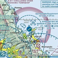
| Sectional chart |
|---|
|
| Airport distance calculator |
|---|
|
|
| Sunrise and sunset |
|---|
|
Times for 18-Nov-2025
| | Local
(UTC-10) | | Zulu
(UTC) |
|---|
| Morning civil twilight | | 06:22 | | 16:22 |
| Sunrise | | 06:45 | | 16:45 |
| Sunset | | 17:48 | | 03:48 |
| Evening civil twilight | | 18:11 | | 04:11 |
|
| Current date and time |
|---|
| Zulu (UTC) | 18-Nov-2025 21:12:15 |
|---|
| Local (UTC-10) | 18-Nov-2025 11:12:15 |
|---|
|
| METAR |
|---|
| PHNG | 182057Z 05011KT 7SM SCT026 27/21 A3005 RMK AO2 SLP170 T02670211 50000
|
PHNL
12nm SW | 182053Z 03012G23KT 10SM FEW025 SCT036 28/19 A3006 RMK AO2 SLP180 T02830189 58002 $
|
PHHI
14nm W | 182055Z AUTO 07010KT 10SM SCT029 26/18 A3009 RMK AO2 SLP180 T02590180 58002 $
|
PHJR
19nm SW | 182053Z 04005KT 10SM FEW036 28/18 A3007 RMK AO2 SLP189 T02830178 58002
|
|
| TAF |
|---|
| PHNG | 1809/1909 07008KT 9999 BKN028 QNH2999INS TEMPO 1809/1815 8000 -SHRA BR TEMPO 1820/1902 SCT028 TX27/1822Z TN21/1813Z LAST NO AMD AFTER 1810 NEXT 1816
|
PHNL
12nm SW | 181738Z 1818/1924 34005KT P6SM VCSH SCT025 SCT040 FM182000 07011G20KT P6SM VCSH SCT025 BKN040 PROB30 1823/1905 P6SM -SHRA BKN025 FM190500 06008KT P6SM VCSH SCT025 BKN035 FM191900 07013G22KT P6SM VCSH SCT025 BKN035 PROB30 1919/1924 P6SM -SHRA BKN025
|
PHHI
14nm W | 181700Z 1817/1921 33004KT 9999 FEW020 SCT050 QNH3007INS BECMG 1820/1821 07008KT 9999 SCT025 BKN035 QNH3001INS TEMPO 1900/1904 8000 -SHRA BR BKN020 BECMG 1904/1905 VRB05KT 9999 SCT020 BKN040 QNH3003INS BECMG 1919/1920 08010KT 9999 SCT025 BKN035 QNH3009INS TX28/1823Z TN20/1814Z
|
PHJR
19nm SW | 181738Z 1818/1918 36005KT P6SM SCT025 FM182000 07010KT P6SM SCT025 SCT040 FM190500 06006KT P6SM VCSH SCT025 BKN040
|
|
| NOTAMs |
|---|
NOTAMs are issued by the DoD/FAA and will open in a separate window not controlled by AirNav.
|
|

