FAA INFORMATION EFFECTIVE 22 JANUARY 2026
Location
| FAA Identifier: | SMX |
| Lat/Long: | 34-53-59.8000N 120-27-29.1000W
34-53.996667N 120-27.485000W
34.8999444,-120.4580833
(estimated) |
| Elevation: | 261.2 ft. / 79.6 m (surveyed) |
| Variation: | 14E (1985) |
| From city: | 3 miles S of SANTA MARIA, CA |
| Time zone: | UTC -8 (UTC -7 during Daylight Saving Time) |
| Zip code: | 93455 |
Airport Operations
| Airport use: | Open to the public |
| Activation date: | 06/1947 |
| Control tower: | yes |
| ARTCC: | LOS ANGELES CENTER |
| FSS: | HAWTHORNE FLIGHT SERVICE STATION |
| NOTAMs facility: | SMX (NOTAM-D service available) |
| Attendance: | 0600-2200 |
| Pattern altitude: | TPA 1000; TURBOJET & PURE JET 1500. |
| Wind indicator: | lighted |
| Segmented circle: | yes |
| Lights: | WHEN ATCT CLSD ACTVT MALSR RWY 12; PAPI RWY 30; HIRL RWY 12/30; TWY LIGHTS - CTAF. PAPI RWY 12 OPER CONSLY. |
| Beacon: | white-green (lighted land airport)
Operates sunset to sunrise. |
| Fire and rescue: | ARFF index B |
| Airline operations: | CLSD TO SUPPLL PART 121 AND PART 135 ACR OPNS EXCP 24 HRS PPR, CALL AMGR (805) 922-1726 WKDAYS 0800-1700. |
Airport Communications
| CTAF: | 118.3 |
| UNICOM: | 122.95 |
| ATIS: | 121.15 |
| WX ASOS: | 121.15 (209-210-1160) |
| SANTA MARIA GROUND: | 121.9 [0600-2000] |
| SANTA MARIA TOWER: | 118.3 239.25 [0600-2000] |
| SANTA BARBARA APPROACH: | 124.15 |
| SANTA BARBARA DEPARTURE: | 124.15 |
| EMERG: | 121.5 |
| WX AWOS-3PT at LPC (14 nm S): | 133.875 (805-735-3075) |
| WX AWOS-3 at L52 (15 nm NW): | 118.375 (805-489-1305) |
- APCH/DEP CTL SVC PRVDD BY LOS ANGELES ARTCC (ZLA) ON FREQS 119.05/269.5 (SAN LUIS OBISPO RCAG) WHEN SANTA BARBARA APCH CTL (SBA) CLSD.
- COMMUNICATIONS PRVDD BY HAWTHORNE RADIO ON FEQS 122.1R/111.0T (GUADALUPE RCO).
Nearby radio navigation aids
| VOR radial/distance | | VOR name | | Freq | | Var |
|---|
| GLJr119/(4.4) | | GUADALUPE VOR | | 113.05 | | 16E |
| MQOr129/25.8 | | MORRO BAY VORTAC | | 112.40 | | 16E |
| GVOr305/28.6 | | GAVIOTA VORTAC | | 113.80 | | 16E |
| FLWr232/31.3 | | FELLOWS VOR/DME | | 117.50 | | 16E |
Airport Services
| Fuel available: | 100LL JET-A
100LL:ACFT FUEL SERVICING AVAILABLE 129.975. |
| Parking: | tiedowns |
| Airframe service: | MAJOR |
| Powerplant service: | MAJOR |
Runway Information
Runway 12/30
| Dimensions: | 8004 x 150 ft. / 2440 x 46 m |
| Surface: | asphalt/grooved, in fair condition |
| Weight bearing capacity: | | Single wheel: | 75.0 | | Double wheel: | 181.0 | | Double tandem: | 400.0 |
|
| Runway edge lights: | high intensity |
| RUNWAY 12 | | RUNWAY 30 |
| Latitude: | 34-54.496692N | | 34-53.557088N |
| Longitude: | 120-27.861532W | | 120-26.737162W |
| Elevation: | 216.8 ft. | | 261.1 ft. |
| Traffic pattern: | right | | left |
| Runway heading: | 121 magnetic, 135 true | | 301 magnetic, 315 true |
| Declared distances: | TORA:8004 TODA:8004 ASDA:8004 LDA:8004 | | TORA:8004 TODA:8004 ASDA:8004 LDA:8004 |
| Markings: | precision, in good condition | | precision, in good condition |
| Visual slope indicator: | 4-light PAPI on right (3.00 degrees glide path) | | 4-light PAPI on right (3.60 degrees glide path) |
| RVR equipment: | touchdown | | rollout |
| Approach lights: | MALSR: 1,400 foot medium intensity approach lighting system with runway alignment indicator lights | | |
| Runway end identifier lights: | no | | no |
| Touchdown point: | yes, no lights | | yes, no lights |
| Instrument approach: | ILS/DME | | |
| Obstructions: | none | | 225 ft. trees, 4700 ft. from runway, 800 ft. left of centerline, 20:1 slope to clear |
Runway 2/20
| Dimensions: | 5199 x 75 ft. / 1585 x 23 m |
| Surface: | asphalt, in good condition |
| Weight bearing capacity: | | Single wheel: | 70.0 | | Double wheel: | 90.0 | | Double tandem: | 150.0 |
|
| Operational restrictions: | RWY 02/20 NOT AVBL FOR PART 121/PART 380 OPS WITH SKED PAX CARRYING OPS MORE THAN 9 PAX SEATS AND NON-SKED PAX CARRYING OPS MORE THAN 30 PAX SEATS. |
| RUNWAY 2 | | RUNWAY 20 |
| Latitude: | 34-53.603380N | | 34-54.296752N |
| Longitude: | 120-28.075890W | | 120-27.464648W |
| Elevation: | 209.5 ft. | | 226.2 ft. |
| Traffic pattern: | right | | left |
| Runway heading: | 022 magnetic, 036 true | | 202 magnetic, 216 true |
| Declared distances: | TORA:5199 TODA:5199 ASDA:5199 LDA:5199 | | TORA:5199 TODA:5199 ASDA:5199 LDA:5199 |
| Markings: | basic, in good condition | | basic, in good condition |
| Runway end identifier lights: | no | | no |
| Touchdown point: | yes, no lights | | yes, no lights |
| Obstructions: | none | | 121 ft. trees, 3640 ft. from runway, 350 ft. right of centerline, 28:1 slope to clear |
Airport Ownership and Management from official FAA records
| Ownership: | Publicly-owned |
| Owner: | SANTA MARIA PUBLIC APT DIST
3217 TERMINAL DR
SANTA MARIA, CA 93455
Phone 805-922-1726 |
| Manager: | MARTIN PEHL
3217 TERMINAL DR
SANTA MARIA, CA 93455
Phone 805-922-1726 |
Additional Remarks
| A39-12/30 | PCR VALUE: 442/F/B/X/U |
| A39-02/20 | PCR VALUE: 200/F/A/Y/T |
| - | CAUTION PARALLEL LGTD ROAD LESS THAN 1/4 MILE NW OF RY 12/30. |
| - | TRANSIENT PILOTS REMAIN CLEAR OF COMMERCIAL RAMP AND TERMINAL. |
| - | SELF SERVE FUEL 100LL AVBL 24 HRS LOCATED NORTH OF TOWER. |
| - | CALM WIND LESS THAN 8 KNOTS USE RWY 30. |
| - | NO TGL OPNS; LANDING PRACTICE OR PRACTICE INSTRUMENT APPROACHES 2200-0700. |
| - | PORTIONS OF TWY J NOT VISIBLE FM ATCT & UNLGTD. |
| - | NUMEROUS BIRDS ON AND INVOF ARPT. |
Instrument Procedures
NOTE: All procedures below are presented as PDF files. If you need a reader for these files, you should download the free Adobe Reader.NOT FOR NAVIGATION. Please procure official charts for flight.
FAA instrument procedures published for use from 22 January 2026 at 0901Z to 19 February 2026 at 0900z.
IAPs - Instrument Approach Procedures |
|---|
| ILS OR LOC RWY 12 | |
download (387KB) |
| RNAV (GPS) RWY 12 | |
download (314KB) |
| RNAV (GPS) RWY 30 | |
download (351KB) |
| LOC/DME BC-A | |
download (447KB) |
| VOR RWY 12 | |
download (349KB) |
| NOTE: Special Alternate Minimums apply | |
download (141KB) |
Departure Procedures |
|---|
| BUELT FOUR | |
download (258KB) |
| NOTE: Special Take-Off Minimums/Departure Procedures apply | |
download (360KB) |
Other nearby airports with instrument procedures:
KVBG - Vandenberg Space Force Base (12 nm SW)
KLPC - Lompoc Airport (14 nm S)
KSBP - San Luis Obispo County Regional Airport (22 nm NW)
KIZA - Santa Ynez Airport/Kunkle Field (26 nm SE)
KSBA - Santa Barbara Municipal Airport (42 nm SE)
|
|

Road maps at:
MapQuest
Bing
Google
| Aerial photo |
|---|
WARNING: Photo may not be current or correct
 Taken in June 2014
looking north.
Taken in June 2014
looking north.
Do you have a better or more recent aerial photo of Santa Maria Public Airport/Capt G Allan Hancock Field that you would like to share? If so, please send us your photo.
|
| Sectional chart |
|---|
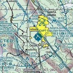
|
CAUTION: Diagram may not be current
 Download PDF
of official airport diagram from the FAA
| Airport distance calculator |
|---|
|
|
| Sunrise and sunset |
|---|
|
Times for 05-Feb-2026
| | Local
(UTC-8) | | Zulu
(UTC) |
|---|
| Morning civil twilight | | 06:32 | | 14:32 |
| Sunrise | | 06:58 | | 14:58 |
| Sunset | | 17:34 | | 01:34 |
| Evening civil twilight | | 18:00 | | 02:00 |
|
| Current date and time |
|---|
| Zulu (UTC) | 06-Feb-2026 03:09:03 |
|---|
| Local (UTC-8) | 05-Feb-2026 19:09:03 |
|---|
|
| METAR |
|---|
| KSMX | 060251Z 17005KT 9SM CLR 15/10 A3001 RMK AO2 SLP167 T01500100 50006 $
|
KLPC
14nm S | 060251Z AUTO 07004KT 10SM CLR 16/10 A3002 RMK AO2 SLP165 T01560100 53007
|
KVBG
17nm S | 060255Z AUTO 00000KT 9SM CLR 14/08 A3001 RMK AO2 SLP165 T01400077 50006 TSNO $
|
|
| TAF |
|---|
| KSMX | 051747Z 0518/0618 VRB03KT P6SM SKC FM052100 15006KT P6SM BKN250 FM052300 26006KT P6SM SCT250 FM060200 VRB03KT P6SM BKN250
|
KVBG
17nm S | 052300Z 0523/0705 17009KT 9999 SCT140 OVC200 QNH2996INS BECMG 0602/0603 13009KT 9999 FEW015 SCT120 BKN200 QNH2998INS BECMG 0607/0608 11010G15KT 9999 SCT012 BKN020 OVC100 QNH3000INS BECMG 0611/0612 15009KT 9999 BKN010 OVC020 QNH3002INS BECMG 0617/0618 12009KT 9999 FEW012 BKN020 BKN120 QNH2998INS BECMG 0619/0620 12010G15KT 9999 SCT020 SCT140 QNH2995INS BECMG 0701/0702 15009KT 9999 BKN012 OVC020 QNH2993INS TEMPO 0702/0705 8000 -SHRA OVC009 TX19/0622Z TN10/0613Z LAST NO AMDS AFT 0601 NEXT 0615
|
|
| NOTAMs |
|---|
NOTAMs are issued by the DoD/FAA and will open in a separate window not controlled by AirNav.
|
|


