FAA INFORMATION EFFECTIVE 11 JUNE 2026
Location
| FAA Identifier: | SUW |
| Lat/Long: | 46-41-22.8627N 092-05-40.7111W
46-41.381045N 092-05.678518W
46.6896841,-92.0946420
(estimated) |
| Elevation: | 674.4 ft. / 205.6 m (surveyed) |
| Variation: | 01W (2015) |
| From city: | 3 miles S of SUPERIOR, WI |
| Time zone: | UTC -5 (UTC -6 during Standard Time) |
| Zip code: | 54880 |
Airport Operations
| Airport use: | Open to the public |
| Activation date: | 10/1937 |
| Control tower: | no |
| ARTCC: | MINNEAPOLIS CENTER |
| FSS: | GREEN BAY FLIGHT SERVICE STATION |
| NOTAMs facility: | SUW (NOTAM-D service available) |
| Attendance: | 0800-DUSK |
| Wind indicator: | lighted |
| Segmented circle: | no |
| Lights: | ACTVT REIL RWY 04, 14, & 32 - CTAF. MIRL RWY 04/22 & RWY 14/32 PRESET TO LOW SS-SR, TO INCR INTST & ACTVT - CTAF. |
| Beacon: | white-green (lighted land airport)
Operates sunset to sunrise. |
Airport Communications
| CTAF/UNICOM: | 122.7 |
| WX AWOS-3: | 120.35 (715-394-0283) |
| DULUTH APPROACH: | 125.45 |
| DULUTH DEPARTURE: | 125.45 |
| CLEARANCE DELIVERY: | 124.8 |
| WX AWOS-3 at DYT (2.8 nm NE): | 119.275 (218-720-4886) |
| WX ASOS at DLH (10 nm NW): | PHONE 218-208-0194 |
| WX AWOS-3 at COQ (17 nm W): | 118.525 (218-879-0783) |
Nearby radio navigation aids
| VOR radial/distance | | VOR name | | Freq | | Var |
|---|
| DLHr142/8.1 | | DULUTH VORTAC | | 112.60 | | 05E |
| NDB name | | Hdg/Dist | | Freq | | Var | | ID |
|---|
| PYKLA | | 131/14.2 | | 379 | | 00E | | DL | -.. .-.. |
Airport Services
| Fuel available: | 100LL JET-A+
100LL:24 HR FUEL AVBL WITH CREDIT CARD. |
| Parking: | hangars and tiedowns |
| Airframe service: | MAJOR |
| Powerplant service: | MAJOR |
| Bottled oxygen: | NONE |
| Bulk oxygen: | NONE |
Runway Information
Runway 4/22
| Dimensions: | 5100 x 75 ft. / 1554 x 23 m |
| Surface: | asphalt, in fair condition |
| Runway edge lights: | medium intensity |
| RUNWAY 4 | | RUNWAY 22 |
| Latitude: | 46-41.349367N | | 46-42.020610N |
| Longitude: | 092-06.017890W | | 092-05.286568W |
| Elevation: | 670.3 ft. | | 659.6 ft. |
| Traffic pattern: | left | | left |
| Runway heading: | 038 magnetic, 037 true | | 218 magnetic, 217 true |
| Markings: | nonprecision, in good condition | | nonprecision, in good condition |
| Visual slope indicator: | 4-light PAPI on left (3.00 degrees glide path) | | |
| Runway end identifier lights: | yes | | no |
| Touchdown point: | yes, no lights | | yes, no lights |
Runway 14/32
| Dimensions: | 4001 x 75 ft. / 1220 x 23 m |
| Surface: | asphalt, in fair condition |
| Runway edge lights: | medium intensity |
| RUNWAY 14 | | RUNWAY 32 |
| Latitude: | 46-41.246130N | | 46-40.740903N |
| Longitude: | 092-06.018493W | | 092-05.405583W |
| Elevation: | 672.1 ft. | | 672.7 ft. |
| Traffic pattern: | left | | left |
| Runway heading: | 141 magnetic, 140 true | | 321 magnetic, 320 true |
| Markings: | nonprecision, in good condition | | nonprecision, in good condition |
| Visual slope indicator: | | | 4-light PAPI on left (4.00 degrees glide path) |
| Runway end identifier lights: | yes | | yes |
| Touchdown point: | yes, no lights | | yes, no lights |
Airport Ownership and Management from official FAA records
| Ownership: | Publicly-owned |
| Owner: | CITY OF SUPERIOR
1316 N. 14TH ST
SUPERIOR, WI 54880
Phone 715-395-7200 |
| Manager: | CALVIN KRAMP
4804 HAMMOND AVE
SUPERIOR, WI 54880
Phone 715-394-0282 |
Additional Remarks
| - | DEER ON & VICINITY OF ARPT. |
| - | FOR CD CTC DULUTH APCH AT 218-740-5950. |
Instrument Procedures
NOTE: All procedures below are presented as PDF files. If you need a reader for these files, you should download the free Adobe Reader.NOT FOR NAVIGATION. Please procure official charts for flight.
FAA instrument procedures published for use from 11 June 2026 at 0901Z to 09 July 2026 at 0900z.
IAPs - Instrument Approach Procedures |
|---|
| RNAV (GPS) RWY 04 | |
download (223KB) |
| RNAV (GPS) RWY 14 | |
download (211KB) |
| RNAV (GPS) RWY 22 | |
download (230KB) |
| RNAV (GPS) RWY 32 | |
download (228KB) |
| NOTE: Special Alternate Minimums apply | |
download (140KB) |
| NOTE: Special Take-Off Minimums/Departure Procedures apply | |
download (270KB) |
Other nearby airports with instrument procedures:
KDYT - Sky Harbor Airport (3 nm NE)
KDLH - Duluth International Airport (10 nm NW)
KCOQ - Cloquet/Carlton County Airport (17 nm W)
KOLG - Solon Springs Municipal Airport (25 nm SE)
KTWM - Richard B Helgeson Airport (26 nm NE)
|
|

Road maps at:
MapQuest
Bing
Google
| Aerial photo |
|---|
WARNING: Photo may not be current or correct
 Photo by Mark Robinson
www.wemakepilots.com
Photo taken 13-Jul-2020
looking southwest.
Do you have a better or more recent aerial photo of Richard I Bong Airport that you would like to share? If so, please send us your photo.
|
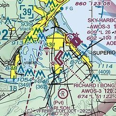
| Sectional chart |
|---|
|
CAUTION: Diagram may not be current

| Airport distance calculator |
|---|
|
|
| Sunrise and sunset |
|---|
|
Times for 15-Jun-2026
| | Local
(UTC-5) | | Zulu
(UTC) |
|---|
| Morning civil twilight | | 04:36 | | 09:36 |
| Sunrise | | 05:15 | | 10:15 |
| Sunset | | 21:03 | | 02:03 |
| Evening civil twilight | | 21:42 | | 02:42 |
|
| Current date and time |
|---|
| Zulu (UTC) | 15-Jun-2026 18:26:45 |
|---|
| Local (UTC-5) | 15-Jun-2026 13:26:45 |
|---|
|
| METAR |
|---|
KDYT
3nm NE | 151815Z AUTO 27015G21KT 10SM FEW075 SCT095 24/07 A2972 RMK AO2
|
KDLH
11nm NW | 151755Z 27014G26KT 10SM SCT060 SCT120 23/06 A2976 RMK AO2 PK WND 25028/1706 SLP078 T02280061 10228 20122 58022 $
|
KCOQ
17nm W | 151815Z AUTO 27014G22KT 10SM CLR 23/03 A2975 RMK AO2 TSNO
|
KSUW
17nm S | 151820Z AUTO 23012G19KT 10SM SCT075 BKN100 25/07 A2974 RMK AO2 T02510067
|
|
| TAF |
|---|
KDLH
11nm NW | 151727Z 1518/1618 26014G23KT P6SM SCT060 SCT120 FM152000 26013G21KT P6SM VCSH BKN060 FM152300 24010G18KT 5SM -SHRA VCTS BKN060CB PROB30 1523/1602 3SM -TSRA OVC050CB FM160200 27005KT 5SM -SHRA BR OVC050 FM160500 VRB04KT 6SM -SHRA BR OVC015 FM161200 34008G15KT P6SM BKN025
|
|
| NOTAMs |
|---|
NOTAMs are issued by the DoD/FAA and will open in a separate window not controlled by AirNav.
|
|


