FAA INFORMATION EFFECTIVE 09 JULY 2026
Location
| FAA Identifier: | T78 |
| Lat/Long: | 30-04-40.1000N 094-41-54.8000W
30-04.668333N 094-41.913333W
30.0778056,-94.6985556
(estimated) |
| Elevation: | 69.5 ft. / 21.2 m (surveyed) |
| Variation: | 05E (1995) |
| From city: | 5 miles E of LIBERTY, TX |
| Time zone: | UTC -5 (UTC -6 during Standard Time) |
| Zip code: | 77575 |
Airport Operations
| Airport use: | Open to the public |
| Activation date: | 08/1959 |
| Control tower: | no |
| ARTCC: | HOUSTON CENTER |
| FSS: | MONTGOMERY COUNTY FLIGHT SERVICE STATION |
| NOTAMs facility: | CXO (NOTAM-D service available) |
| Attendance: | MON-FRI 0800-1600 |
| Wind indicator: | lighted |
| Segmented circle: | yes |
| Lights: | ACTVT MIRL RWY 16/34 - CTAF. |
| Beacon: | white-green (lighted land airport)
Operates sunset to sunrise. |
Airport Communications
| CTAF: | 122.9 |
| WX AWOS-3PT: | 120.775 (936-587-4150) |
| HOUSTON APPROACH: | 119.7 |
| HOUSTON DEPARTURE: | 119.7 |
| BLTWY RNAV DP: | 119.7 |
| BORRN RNAV DP: | 119.7 |
| DREMR DP: | 119.7 |
| HOODO RNAV DP: | 119.7 |
| HUDZY STAR: | 120.05 |
| INDIE RNAV DP: | 119.7 |
| KARRR RNAV DP: | 119.7 |
| LURIC RNAV DP: | 119.7 |
| MMALT RNAV DP: | 119.7 |
| PIEGY RNAV STAR: | 119.7 |
| RIICE STAR: | 124.35 |
| STRYA DP: | 119.7 |
| STYCK DP: | 119.7 |
| WATFO DP: | 119.7 |
| WYLSN RNAV DP: | 119.7 |
Nearby radio navigation aids
| VOR radial/distance | | VOR name | | Freq | | Var |
|---|
| DASr197/7.3 | | DAISETTA VORTAC | | 116.90 | | 05E |
| MHFr358/32.0 | | TRINITY VOR/DME | | 114.75 | | 07E |
| IAHr073/34.4 | | HUMBLE VORTAC | | 116.60 | | 05E |
| NDB name | | Hdg/Dist | | Freq | | Var | | ID |
|---|
| GOODHUE | | 264/25.3 | | 368 | | 07E | | GDE | --. -.. . |
Airport Services
| Fuel available: | 100LL JET-A
100LL:24 HR SELF-SVC FUEL. |
| Parking: | tiedowns |
| Airframe service: | MAJOR |
| Powerplant service: | MAJOR |
| Bottled oxygen: | NONE |
| Bulk oxygen: | NONE |
Runway Information
Runway 16/34
| Dimensions: | 3801 x 75 ft. / 1159 x 23 m |
| Surface: | asphalt, in good condition |
| Weight bearing capacity: | |
| Runway edge lights: | medium intensity |
| RUNWAY 16 | | RUNWAY 34 |
| Latitude: | 30-04.971517N | | 30-04.363658N |
| Longitude: | 094-42.001210W | | 094-41.824053W |
| Elevation: | 68.9 ft. | | 68.6 ft. |
| Traffic pattern: | left | | left |
| Runway heading: | 161 magnetic, 166 true | | 341 magnetic, 346 true |
| Markings: | nonprecision, in good condition | | nonprecision, in good condition |
| Visual slope indicator: | 2-light PAPI on left (3.00 degrees glide path) | | |
| Touchdown point: | yes, no lights | | yes, no lights |
| Obstructions: | 40 ft. trees, 220 ft. from runway, 248 ft. right of centerline
10 FT FENCE, 0-199 FT DSTC, 245 FT R. | | 65 ft. trees, 1250 ft. from runway, 150 ft. right of centerline, 16:1 slope to clear |
Airport Ownership and Management from official FAA records
| Ownership: | Publicly-owned |
| Owner: | CITY OF LIBERTY
1829 SAM HOUSTON
LIBERTY, TX 77575
Phone 936-336-3684 |
| Manager: | MARK BUSH
1829 SAM HOUSTON
LIBERTY, TX 77575
Phone 936-352-1048 |
Additional Remarks
| - | FOR CD CTC HOUSTON APCH AT 281-443-5844 TO CNL IFR CALL 281-443-5888. |
Instrument Procedures
NOTE: All procedures below are presented as PDF files. If you need a reader for these files, you should download the free Adobe Reader.NOT FOR NAVIGATION. Please procure official charts for flight.
FAA instrument procedures published for use from 09 July 2026 at 0901Z to 06 August 2026 at 0900Z.
STARs - Standard Terminal Arrivals |
|---|
| BAZBL ONE (RNAV) **NEW** | |
download (255KB) |
| HUDZY FIVE **CHANGED** | |
2 pages:
[1] [2] (282KB) |
| OHIIO FOUR **CHANGED** | |
download (265KB) |
| PIEGY ONE (RNAV) **NEW** | |
download (134KB) |
| RIICE ONE **NEW** | |
2 pages:
[1] [2] (505KB) |
IAPs - Instrument Approach Procedures |
|---|
| RNAV (GPS) RWY 16 | |
download (163KB) |
| VOR-A | |
download (147KB) |
Departure Procedures |
|---|
| BLTWY SEVEN (RNAV) | |
download (146KB) |
| BORRN SIX (RNAV) | |
2 pages:
[1] [2] (289KB) |
| HOODO SEVEN (RNAV) | |
download (188KB) |
| INDIE EIGHT (RNAV) | |
download (173KB) |
| KARRR SEVEN (RNAV) | |
2 pages:
[1] [2] (236KB) |
| LURIC EIGHT (RNAV) | |
download (195KB) |
| MMALT SEVEN (RNAV) | |
download (199KB) |
| STRYA EIGHT (RNAV) | |
download (183KB) |
| STYCK EIGHT (RNAV) | |
download (170KB) |
| WATFO SIX (RNAV) | |
download (154KB) |
| WYLSN EIGHT (RNAV) | |
download (158KB) |
| NOTE: Special Take-Off Minimums/Departure Procedures apply | |
download |
Other nearby airports with instrument procedures:
T00 - Chambers County Airport (19 nm S)
54T - RWJ Airpark (20 nm S)
T90 - Chambers County/Winnie Stowell Airport (21 nm SE)
KHPY - Baytown Airport (22 nm SW)
6R3 - Cleveland Municipal Airport (23 nm NW)
|
|

Road maps at:
MapQuest
Bing
Google
| Aerial photo |
|---|
WARNING: Photo may not be current or correct
 Photo by David Lawrence flying a 78 Bellanca/17-30A
Photo taken 08-Nov-2014
looking north.
Photo by David Lawrence flying a 78 Bellanca/17-30A
Photo taken 08-Nov-2014
looking north.
Do you have a better or more recent aerial photo of Liberty Municipal Airport that you would like to share? If so, please send us your photo.
|
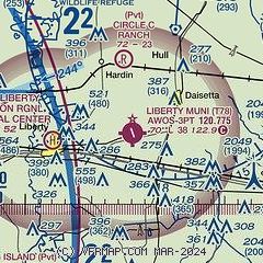
| Sectional chart |
|---|
|
| Airport distance calculator |
|---|
|
|
| Sunrise and sunset |
|---|
|
Times for 18-Jul-2026
| | Local
(UTC-5) | | Zulu
(UTC) |
|---|
| Morning civil twilight | | 06:04 | | 11:04 |
| Sunrise | | 06:30 | | 11:30 |
| Sunset | | 20:20 | | 01:20 |
| Evening civil twilight | | 20:46 | | 01:46 |
|
| Current date and time |
|---|
| Zulu (UTC) | 19-Jul-2026 01:26:38 |
|---|
| Local (UTC-5) | 18-Jul-2026 20:26:38 |
|---|
|
| METAR |
|---|
K6R3
23nm NW | 190115Z AUTO 16003KT 10SM CLR A3000 RMK AO2
|
KBMT
25nm E | 190115Z AUTO 19003KT 10SM CLR 28/24 A2999 RMK AO2 T02810241
|
KT41
31nm SW | 190115Z AUTO 20008KT 10SM CLR 30/24 A3000 RMK AO2
|
KIAH
35nm W | 190053Z 17009KT 10SM FEW040 SCT250 32/24 A2998 RMK AO2 SLP150 T03170244 $
|
KBPT
35nm E | 190053Z 19008KT 10SM CLR 29/25 A2999 RMK AO2 SLP156 T02890250
|
KEFD
38nm SW | 182154Z 15011KT 10SM SCT040 32/25 A3001
|
KHOU
40nm SW | 190053Z 18012KT 8SM FEW032 BKN300 31/24 A2999 RMK AO2 SLP158 T03060244
|
KCXO
41nm NW | 190053Z 13008KT 10SM CLR 31/26 A2998 RMK AO2 SLP149 T03110261
|
KDWH
44nm W | 190053Z 21009KT 8SM FEW050 32/22 A2998 RMK AO2 SLP149 T03170222
|
KLVJ
44nm SW | 190053Z AUTO 18009KT 9SM CLR 31/23 A3001 RMK AO2 SLP162 T03060233
|
|
| TAF |
|---|
KIAH
35nm W | 182037Z 1821/1924 16009KT P6SM SCT050 SCT250 FM190300 20005KT P6SM FEW020 SCT250
|
KBPT
35nm E | 181720Z 1818/1918 22006KT P6SM BKN250
|
KHOU
40nm SW | 182037Z 1821/1918 18010KT P6SM SCT045 SCT250 FM190400 21005KT P6SM FEW020 SCT250
|
KCXO
41nm NW | 181736Z 1818/1918 18008KT P6SM SCT020 BKN035 FM190000 15005KT P6SM SCT250 FM190700 VRB02KT 6SM BR SCT020 OVC250
|
|
| NOTAMs |
|---|
NOTAMs are issued by the DoD/FAA and will open in a separate window not controlled by AirNav.
|
|

