FAA INFORMATION EFFECTIVE 09 JULY 2026
Location
| FAA Identifier: | T85 |
| Lat/Long: | 29-18-47.4000N 097-08-18.3000W
29-18.790000N 097-08.305000W
29.3131667,-97.1384167
(estimated) |
| Elevation: | 365.4 ft. / 111.4 m (surveyed) |
| Variation: | 06E (1995) |
| From city: | 1 mile N of YOAKUM, TX |
| Time zone: | UTC -5 (UTC -6 during Standard Time) |
| Zip code: | 77995 |
Airport Operations
| Airport use: | Open to the public |
| Activation date: | 01/1970 |
| Control tower: | no |
| ARTCC: | HOUSTON CENTER |
| FSS: | MONTGOMERY COUNTY FLIGHT SERVICE STATION |
| NOTAMs facility: | CXO (NOTAM-D service available) |
| Attendance: | UNATNDD |
| Wind indicator: | lighted |
| Segmented circle: | yes |
| Lights: | SS-SR |
| Beacon: | white-green (lighted land airport)
Operates sunset to sunrise. |
Airport Communications
- APCH/DEP CTL SVC PRVDD BY HOUSTON ARTCC (ZHU) ON FREQS 132.8/343.7 (SAN ANTONIO RCAG).
Nearby radio navigation aids
| VOR radial/distance | | VOR name | | Freq | | Var |
|---|
| VCTr335/26.1 | | VICTORIA VOR/DME | | 109.00 | | 06E |
Airport Services
Runway Information
Runway 13/31
| Dimensions: | 3444 x 60 ft. / 1050 x 18 m |
| Surface: | asphalt, in excellent condition |
| Weight bearing capacity: | |
| Runway edge lights: | medium intensity |
| RUNWAY 13 | | RUNWAY 31 |
| Latitude: | 29-18.988100N | | 29-18.592213N |
| Longitude: | 097-08.536848W | | 097-08.071732W |
| Elevation: | 365.1 ft. | | 341.1 ft. |
| Traffic pattern: | left | | left |
| Runway heading: | 128 magnetic, 134 true | | 308 magnetic, 314 true |
| Markings: | nonprecision, in good condition | | nonprecision, in good condition |
| Touchdown point: | yes, no lights | | yes, no lights |
| Obstructions: | 45 ft. pole, 998 ft. from runway, 240 ft. left of centerline, 17:1 slope to clear | | 42 ft. pole, marked and lighted, 1230 ft. from runway, 170 ft. right of centerline, 24:1 slope to clear |
Airport Ownership and Management from official FAA records
| Ownership: | Publicly-owned |
| Owner: | CITY OF YOAKUM
PO BOX 738
YOAKUM, TX 77995
Phone 361-293-6321 |
| Manager: | MICHAEL MITCHELL
PO BOX 738
YOAKUM, TX 77995-0738
Phone 361-293-6321 |
Additional Remarks
| - | FOR CD CTC HOUSTON ARTCC AT 281-230-5622. |
Instrument Procedures
NOTE: All procedures below are presented as PDF files. If you need a reader for these files, you should download the free Adobe Reader.NOT FOR NAVIGATION. Please procure official charts for flight.
FAA instrument procedures published for use from 09 July 2026 at 0901Z to 06 August 2026 at 0900Z.
IAPs - Instrument Approach Procedures |
|---|
| RNAV (GPS) RWY 31 | |
download (167KB) |
| NOTE: Special Take-Off Minimums/Departure Procedures apply | |
download (107KB) |
Other nearby airports with instrument procedures:
KVCT - Victoria Regional Airport (30 nm SE)
26R - Jackson County Airport (35 nm SE)
3T5 - Fayette Regional Air Center Airport (37 nm N)
50R - Lockhart Municipal Airport (43 nm NW)
84R - Smithville Crawford Municipal Airport (43 nm N)
|
|

Road maps at:
MapQuest
Bing
Google
| Aerial photo |
|---|
WARNING: Photo may not be current or correct

Do you have a better or more recent aerial photo of Yoakum Municipal Airport that you would like to share? If so, please send us your photo.
|
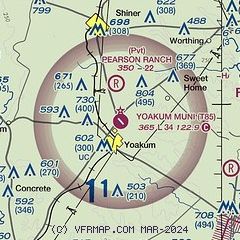
| Sectional chart |
|---|
|
| Airport distance calculator |
|---|
|
|
| Sunrise and sunset |
|---|
|
Times for 22-Jul-2026
| | Local
(UTC-5) | | Zulu
(UTC) |
|---|
| Morning civil twilight | | 06:18 | | 11:18 |
| Sunrise | | 06:44 | | 11:44 |
| Sunset | | 20:26 | | 01:26 |
| Evening civil twilight | | 20:52 | | 01:52 |
|
| Current date and time |
|---|
| Zulu (UTC) | 22-Jul-2026 18:47:29 |
|---|
| Local (UTC-5) | 22-Jul-2026 13:47:29 |
|---|
|
| METAR |
|---|
KT20
21nm NW | 221835Z AUTO 00000KT 10SM SCT070 37/22 A2988 RMK AO2 T03710216
|
KVCT
29nm S | 221751Z 00000KT 10SM CLR 35/24 A2989 RMK AO2 SLP118 T03500239 10350 20244 56010
|
K3T5
37nm N | 221835Z AUTO 10005KT 9SM FEW300 37/17 A2988 RMK AO2 T03750170 $
|
K66R
38nm NE | 221835Z AUTO 01003KT 10SM CLR 38/22 A2988 RMK AO2 T03750222
|
|
| TAF |
|---|
KVCT
29nm S | 221720Z 2218/2318 VRB06KT P6SM FEW020 FM230500 VRB04KT P6SM BKN250 FM231600 36007KT P6SM SCT250
|
|
| NOTAMs |
|---|
NOTAMs are issued by the DoD/FAA and will open in a separate window not controlled by AirNav.
|
|

