FAA INFORMATION EFFECTIVE 30 OCTOBER 2025
Location
| FAA Identifier: | TBN |
| Lat/Long: | 37-44-29.9000N 092-08-26.6000W
37-44.498333N 092-08.443333W
37.7416389,-92.1407222
(estimated) |
| Elevation: | 1159.5 ft. / 353.4 m (surveyed) |
| Variation: | 00E (2020) |
| Time zone: | UTC -6 (UTC -5 during Daylight Saving Time) |
| Zip code: | 65473 |
Airport Operations
| Airport use: | Open to the public |
| Activation date: | 04/1944 |
| Control tower: | yes |
| ARTCC: | KANSAS CITY CENTER |
| FSS: | COLUMBIA FLIGHT SERVICE STATION |
| NOTAMs facility: | TBN (NOTAM-D service available) |
| Attendance: | MON-FRI 0800-1700
EXCLUDING HOLS. |
| Wind indicator: | lighted |
| Segmented circle: | no |
| Lights: | WHEN TWR CLSD ACTVT MALS RWY 33; MALSR RWY 15; REIL RWY 15 & 33; PAPI RWY 15 & 33; HIRL RWY 15/33 - CTAF. |
| Beacon: | white-white-green (lighted military airport)
Operates sunset to sunrise. |
| Fire and rescue: | ARFF index A |
Airport Communications
| CTAF: | 125.4 |
| WX ASOS: | 118.7 |
| FORNEY GROUND: | 123.75 256.8 [1300-0400Z++ MON-FRI EXC HOL] |
| FORNEY TOWER: | 125.4 268.7 [1300-0400Z++ MON-FRI EXC HOL] |
| ARNG OPS: | 140.2 245.7 32.125 |
| D-ATIS: | 118.7 229.4 |
| EMERG: | 121.5 243.0 |
| OPS: | 122.95 ;FORNEY OPS 237.5 ;FORNEY OPS |
- APCH/DEP SVC PRVDD BY KANSAS CITY ARTCC ON FREQS 128.35/284.675 (RICHLAND RCAG).
Nearby radio navigation aids
| VOR radial/distance | | VOR name | | Freq | | Var |
|---|
| TBN at field | | FORNEY VOR | | 110.00 | | 00E |
| SHYr129/28.3 | | SUNSHINE VOR/DME | | 108.40 | | 00E |
| VIHr214/32.2 | | VICHY VOR/DME | | 117.70 | | 06E |
Airport Services
| Fuel available: | 100LL JET-A |
| Parking: | hangars and tiedowns |
| Airframe service: | NONE |
| Powerplant service: | NONE |
| Bottled oxygen: | NONE |
| Bulk oxygen: | NONE |
Runway Information
Runway 15/33
| Dimensions: | 6037 x 150 ft. / 1840 x 46 m |
| Surface: | asphalt, in good condition |
| Weight bearing capacity: | |
| Runway edge lights: | high intensity |
| RUNWAY 15 | | RUNWAY 33 |
| Latitude: | 37-44.915560N | | 37-44.079733N |
| Longitude: | 092-08.783595W | | 092-08.104528W |
| Elevation: | 1159.4 ft. | | 1154.9 ft. |
| Traffic pattern: | left | | right |
| Runway heading: | 147 | | 327 |
| Displaced threshold: | 502 ft. | | 527 ft. |
| Markings: | precision, in good condition | | precision, in good condition |
| Visual slope indicator: | 4-light PAPI on left (3.00 degrees glide path) | | 4-light PAPI on right (3.00 degrees glide path) |
| RVR equipment: | rollout | | touchdown |
| Approach lights: | MALSR: 1,400 foot medium intensity approach lighting system with runway alignment indicator lights | | MALS: 1,400 foot medium intensity approach lighting system |
| Runway end identifier lights: | yes | | yes |
| Touchdown point: | yes, no lights | | yes, no lights |
| Instrument approach: | ILS/DME | | |
| Obstructions: | 9 ft. pole, 210 ft. from runway, 450 ft. left of centerline, 1:1 slope to clear
50:1 TO DSPLCD THR. | | 17 ft. road, 450 ft. from runway, 14:1 slope to clear
+15' GND AT 200'; 200-500' R CTRLN; OBST LIGHTED FENCE. |
Airport Ownership and Management from official FAA records
| Ownership: | U.S. Army |
| Owner: | U S ARMY
FORNEY ARMY AIRFIELD
FT LEONARD WOOD, MO 65473
Phone 573-596-0165 |
| Manager: | MIKE GUY
FORNEY ARMY AIRFIELD
FT LEONARD WOOD, MO 65473
Phone 573-596-0165
AIRPORT MANAGER (CIVIL) MIKE GUY 573-329-4216 |
Additional Remarks
| - | RSTD: PPR FOR ALL TRAN MIL ACFT DSN 581-0165/4819; C573-596-0165/4819. |
| - | ARR AND DEP LRG ACFT MUST USE THE ALPHA TWY INT AT THE SE EOR 15-33 TO ACES AND EXIT THE RWY. ARR AND DEP LRG ACFT ARE REQUIRED TO BACK-TAXI ON THE RWY. |
| - | SFC VSBY LIMITED BY TREE LINE FM E TO S TO W. |
| - | WX SVC AVBL MON-FRI EXC HOL 1300-0400Z++. AN/FMQ-19 AUTOMATED OBSERVING SYS IN USE; AUGMENTED BY HUMAN OBSN WHEN NEC DUR AFLD HRS. OT REMOTE BRIEFING SVC AVBL 26 OWS BARKSDALE AFB DSN 781-4775, C318-456-4775, C866-223-2398 (TOLL FREE). |
| - | MILITARY SERVICE: NO MIL FUEL AVBL. CIV: NC A AVBL 1400-2300Z++ OT C573-329-4216. 100LL AVBL H24 WITH CREDIT CARD. |
| - | MILITARY: SVC: SOUTH END OF RWY SAFETY ZONE UNPROTECTED WHEN TWR CLSD. |
| - | WHEN ATCT CLSD, FOR CD CTC KANSAS CITY ARTCC AT 913-254-8508. |
| - | RSTD: CIV FBO RAMP CLSD TO MIL ACFT. |
Instrument Procedures
NOTE: All procedures below are presented as PDF files. If you need a reader for these files, you should download the free Adobe Reader.NOT FOR NAVIGATION. Please procure official charts for flight.
FAA instrument procedures published for use from 30 October 2025 at 0901Z to 27 November 2025 at 0900Z.
IAPs - Instrument Approach Procedures |
|---|
| ILS OR LOC RWY 15 | |
download (356KB) |
| RNAV (GPS) RWY 15 | |
download (257KB) |
| RNAV (GPS) RWY 33 | |
download (300KB) |
| VOR RWY 15 | |
download (284KB) |
| VOR RWY 33 | |
download (254KB) |
| NOTE: Special Alternate Minimums apply | |
download (145KB) |
| NOTE: Special Take-Off Minimums/Departure Procedures apply | |
download (421KB) |
Other nearby airports with instrument procedures:
KLBO - Floyd W Jones Lebanon Airport (25 nm W)
M48 - Houston Memorial Airport (26 nm S)
K33 - Salem Memorial Airport (27 nm E)
KAIZ - Lee C Fine Memorial Airport (29 nm NW)
KVIH - Rolla National Airport (29 nm NE)
|
|

Road maps at:
MapQuest
Bing
Google
| Aerial photo |
|---|
WARNING: Photo may not be current or correct

Do you have a better or more recent aerial photo of Waynesville-St. Robert Regional Airport-Forney Field that you would like to share? If so, please send us your photo.
|
| Sectional chart |
|---|
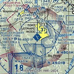
|
 Download PDF
of official airport diagram from the FAA
| Airport distance calculator |
|---|
|
|
| Sunrise and sunset |
|---|
|
Times for 18-Nov-2025
| | Local
(UTC-6) | | Zulu
(UTC) |
|---|
| Morning civil twilight | | 06:25 | | 12:25 |
| Sunrise | | 06:53 | | 12:53 |
| Sunset | | 16:55 | | 22:55 |
| Evening civil twilight | | 17:23 | | 23:23 |
|
| Current date and time |
|---|
| Zulu (UTC) | 18-Nov-2025 16:39:44 |
|---|
| Local (UTC-6) | 18-Nov-2025 10:39:44 |
|---|
|
| METAR |
|---|
KTBN
2nm SE | 181555Z AUTO 20007KT 10SM FEW019 SCT028 20/16 A2982 RMK AO2 SLP095 T02030161
|
|
| TAF |
|---|
KTBN
2nm SE | 181400Z 1814/1920 20009KT 9999 FEW250 520006 QNH2979INS BECMG 1818/1819 25010G15KT 9999 SCT030 QNH2983INS BECMG 1821/1822 29009KT 9999 FEW028 QNH2983INS BECMG 1907/1908 35003KT 4000 BR BKN007 OVC014 QNH3001INS BECMG 1910/1911 02003KT 0800 FG OVC004 QNH3020INS BECMG 1917/1918 27003KT 8000 BR SCT008 BKN015 QNH3019INS TX23/1820Z TN11/1913Z
|
|
| NOTAMs |
|---|
NOTAMs are issued by the DoD/FAA and will open in a separate window not controlled by AirNav.
|
|


