FAA INFORMATION EFFECTIVE 07 AUGUST 2025
Location
| FAA Identifier: | W42 |
| Lat/Long: | 39-30-04.7650N 076-24-40.8050W
39-30.079417N 076-24.680083W
39.5013236,-76.4113347
(estimated) |
| Elevation: | 460 ft. / 140 m (estimated) |
| Variation: | 10W (1985) |
| From city: | 1 mile S of FALLSTON, MD |
| Time zone: | UTC -4 (UTC -5 during Standard Time) |
| Zip code: | 21047 |
Airport Operations
| Airport use: | Open to the public |
| Activation date: | 06/1960 |
| Control tower: | no |
| ARTCC: | WASHINGTON CENTER |
| FSS: | LEESBURG FLIGHT SERVICE STATION |
| NOTAMs facility: | DCA (NOTAM-D service available) |
| Attendance: | UNATNDD
IF ATTENDENT NOT PRESENT DURG DALGT HOURS CALL 410-877-9889. |
| Wind indicator: | yes |
| Segmented circle: | no |
| Lights: | NSTD LIRL AVAILABLE TO BASED AIRCRAFT W/PRIOR NOTICE. FOR NSTD LIRL RY 04/22 CTC AMGR 410-877-9889. |
Airport Communications
| CTAF: | 122.9 |
| WX AWOS-3PT at 0W3 (10 nm NE): | 132.725 (667-340-6003) |
| WX AWOS-3PT at MTN (11 nm S): | 124.925 (410-682-8848) |
Nearby radio navigation aids
| VOR radial/distance | | VOR name | | Freq | | Var |
|---|
| BALr041/23.0 | | BALTIMORE VORTAC | | 115.10 | | 11W |
| EMIr097/26.3 | | WESTMINSTER VORTAC | | 117.90 | | 08W |
| LRPr197/37.5 | | LANCASTER VOR/DME | | 117.30 | | 09W |
| DQOr264/38.7 | | DUPONT VORTAC | | 114.00 | | 10W |
| NDB name | | Hdg/Dist | | Freq | | Var | | ID |
|---|
| ELLICOTT | | 064/21.3 | | 371 | | 11W | | FND | ..-. -. -.. |
Airport Services
| Fuel available: | 100LL
100LL:IF NO ONE PPRESENT DURING DAYLIGHT HOURS CALL 410-877-9889. |
| Parking: | tiedowns |
| Airframe service: | NONE |
| Powerplant service: | NONE |
| Bottled oxygen: | NONE |
| Bulk oxygen: | NONE |
Runway Information
Runway 4/22
| Dimensions: | 2200 x 50 ft. / 671 x 15 m |
| Surface: | asphalt, in poor condition
CRACKING, FOD POSS. |
| Weight bearing capacity: | |
| Runway edge lights: | non-standard
RY 04/22 NSTD LIRL; TWO THLD LGTS EACH SIDE & 300 FT EDGE LGT SPACING. |
| RUNWAY 4 | | RUNWAY 22 |
| Latitude: | 39-29.919667N | | 39-30.239167N |
| Longitude: | 076-24.790667W | | 076-24.569500W |
| Elevation: | 460.0 ft. | | 460.0 ft. |
| Traffic pattern: | left | | left |
| Runway heading: | 038 magnetic, 028 true | | 218 magnetic, 208 true |
| Displaced threshold: | 315 ft. | | 230 ft. |
| Markings: | basic, in fair condition | | basic, in fair condition |
| Obstructions: | 81 ft. trees, 1200 ft. from runway, 169 ft. right of centerline, 12:1 slope to clear
RY 04 HAS +10 FT ROAD 45 FT FM THLD. | | 79 ft. trees, 1369 ft. from runway, 216 ft. left of centerline, 14:1 slope to clear
+15 FT ACCESS ROAD AT THLD; +25 FT BLDG, 137 FT L OF APCH NMRS. |
Airport Ownership and Management from official FAA records
| Ownership: | Privately-owned |
| Owner: | FALLSTON AIRPORT & FLYING SERVICE
711 RECKORD RD
FALLSTON, MD 21047
Phone 410-877-9889
FULL OWNER NAME: FALLSTON AIRPORT & FLYING SERVICE, INC. |
| Manager: | SHARON MILLS AND MICHAEL MILLS
711 RECKORD RD
FALLSTON, MD 21047
Phone 410-877-9889
ALTERNATE EMERGENCY PHONE (410) 808-3289 |
Additional Remarks
| - | ARPT CLSD DUSK-0900 DAILY. |
| - | DEER & WILDLIFE ON & INVOF ARPT. |
| - | FOR CD CTC POTOMAC APCH AT 866-429-5882. |
Instrument Procedures
There are no published instrument procedures at W42.
Some nearby airports with instrument procedures:
KEDG - Weide Army Heliport (Aberdeen Proving Ground) (9 nm SE)
0W3 - Harford County Airport (10 nm NE)
KMTN - Martin State Airport (11 nm S)
KAPG - Phillips Army Airfield (11 nm E)
KBWI - Baltimore/Washington International Thurgood Marshall Airport (23 nm SW)
|
|

Road maps at:
MapQuest
Bing
Google
| Aerial photo |
|---|
WARNING: Photo may not be current or correct
 Photo taken 14-Oct-2016
looking north.
Photo taken 14-Oct-2016
looking north.
Do you have a better or more recent aerial photo of Fallston Airport that you would like to share? If so, please send us your photo.
|
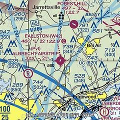
| Sectional chart |
|---|
|
| Airport distance calculator |
|---|
|
|
| Sunrise and sunset |
|---|
|
Times for 20-Aug-2025
| | Local
(UTC-4) | | Zulu
(UTC) |
|---|
| Morning civil twilight | | 05:55 | | 09:55 |
| Sunrise | | 06:24 | | 10:24 |
| Sunset | | 19:54 | | 23:54 |
| Evening civil twilight | | 20:23 | | 00:23 |
|
| Current date and time |
|---|
| Zulu (UTC) | 20-Aug-2025 19:50:42 |
|---|
| Local (UTC-4) | 20-Aug-2025 15:50:42 |
|---|
|
| METAR |
|---|
KMTN
11nm S | 201941Z 01004KT 10SM BKN010 OVC014 25/22 A2996
|
KAPG
16nm E | 201855Z AUTO 03007KT 10SM OVC006 24/22 A2995 RMK AO2 SLP144 T02390221 $
|
KDMH
16nm SW | 201853Z AUTO 24/22 A2996 RMK AO1 SLP144 T02440217
|
|
| TAF |
|---|
KMTN
11nm S | 201727Z 2018/2118 08004KT P6SM OVC006 FM202100 13007KT P6SM OVC015 FM210200 07005KT P6SM OVC006 FM211300 03011G18KT 6SM BR OVC006 FM211700 03012G19KT P6SM BKN008
|
|
| NOTAMs |
|---|
NOTAMs are issued by the DoD/FAA and will open in a separate window not controlled by AirNav.
|
|

