FAA INFORMATION EFFECTIVE 27 NOVEMBER 2025
Location
| FAA Identifier: | X35 |
| Lat/Long: | 29-03-42.3620N 082-22-35.8300W
29-03.706033N 082-22.597167W
29.0617672,-82.3766194
(estimated) |
| Elevation: | 65.4 ft. / 19.9 m (surveyed) |
| Variation: | 05W (2010) |
| From city: | 5 miles E of DUNNELLON, FL |
| Time zone: | UTC -5 (UTC -4 during Daylight Saving Time) |
| Zip code: | 34432 |
Airport Operations
| Airport use: | Open to the public |
| Activation date: | 08/1942 |
| Control tower: | no |
| ARTCC: | JACKSONVILLE CENTER |
| FSS: | GAINESVILLE FLIGHT SERVICE STATION |
| NOTAMs facility: | GNV (NOTAM-D service available) |
| Attendance: | MON-FRI 0800-1600 |
| Wind indicator: | yes |
| Segmented circle: | yes |
| Lights: | ACTVT PAPI RWY 05 & 23; MIRL RWY 05/23 & 10/28 - CTAF. |
| Beacon: | white-green (lighted land airport)
Operates sunset to sunrise. |
Airport Communications
| CTAF/UNICOM: | 122.8 |
| JACKSONVILLE APPROACH: | 118.6 |
| JACKSONVILLE DEPARTURE: | 118.6 |
| WX AWOS-3PT at OCF (10 nm NE): | 128.125 (352-237-8525) |
| WX AWOS-3 at CGC (16 nm SW): | 118.325 (352-563-6600) |
| WX AWOS-3 at INF (16 nm S): | 119.975 (352-560-6012) |
| WX AWOS-3T at X60 (18 nm N): | 118.425 (352-528-9949) |
Nearby radio navigation aids
| VOR radial/distance | | VOR name | | Freq | | Var |
|---|
| OCFr229/10.5 | | OCALA VORTAC | | 113.70 | | 00E |
| GNVr192/38.2 | | GATORS VORTAC | | 116.20 | | 04W |
Airport Services
| Fuel available: | 100LL JET-A+
100LL:CREDIT CARD FUEL AVBL H24.
A+:JET A WITH PRIST. |
| Parking: | tiedowns |
| Airframe service: | MAJOR |
| Powerplant service: | MAJOR |
| Bottled oxygen: | NONE |
| Bulk oxygen: | NONE |
Runway Information
Runway 5/23
| Dimensions: | 5000 x 100 ft. / 1524 x 30 m |
| Surface: | asphalt, in fair condition |
| Weight bearing capacity: | |
| Runway edge lights: | medium intensity |
| RUNWAY 5 | | RUNWAY 23 |
| Latitude: | 29-03.549783N | | 29-04.130707N |
| Longitude: | 082-22.922790W | | 082-22.256017W |
| Elevation: | 63.2 ft. | | 65.2 ft. |
| Traffic pattern: | left | | left |
| Runway heading: | 050 magnetic, 045 true | | 230 magnetic, 225 true |
| Markings: | nonprecision, in fair condition | | nonprecision, in fair condition |
| Visual slope indicator: | 4-light PAPI on left (3.00 degrees glide path) | | 4-light PAPI on left (3.00 degrees glide path) |
| Touchdown point: | yes, no lights | | yes, no lights |
| Obstructions: | 62 ft. trees, 1455 ft. from runway, 240 ft. right of centerline, 20:1 slope to clear | | 57 ft. tree, 2240 ft. from runway, 60 ft. left of centerline, 36:1 slope to clear |
Runway 10/28
| Dimensions: | 4701 x 60 ft. / 1433 x 18 m |
| Surface: | asphalt, in fair condition |
| Weight bearing capacity: | |
| Runway edge lights: | medium intensity |
| RUNWAY 10 | | RUNWAY 28 |
| Latitude: | 29-03.564913N | | 29-03.561625N |
| Longitude: | 082-23.046858W | | 082-22.163972W |
| Elevation: | 64.1 ft. | | 63.3 ft. |
| Traffic pattern: | left | | left |
| Runway heading: | 095 magnetic, 090 true | | 275 magnetic, 270 true |
| Markings: | basic, in fair condition | | basic, in fair condition |
| Touchdown point: | yes, no lights | | yes, no lights |
| Obstructions: | 57 ft. trees, 1950 ft. from runway, 31:1 slope to clear | | 57 ft. trees, 2120 ft. from runway, 90 ft. right of centerline, 34:1 slope to clear |
Airport Ownership and Management from official FAA records
| Ownership: | Publicly-owned |
| Owner: | MARION COUNTY BOARD OF COMMISSIONER
601 SE 25TH AVE
OCALA, FL 34471
Phone 352-438-2300
CONTACT PERSON: ANGEL ROUSSEL 352-438-2300 |
| Manager: | JORGE NIEVES
14968 SW 107TH STREET
DUNNELLON, FL 34432
Phone 352-465-8545 |
Additional Remarks
| - | FOR CD CTC JACKSONVILLE APCH AT 904-741-0284. |
| - | WX ADV CLICK 4 TIMES ON CTAF. |
Instrument Procedures
NOTE: All procedures below are presented as PDF files. If you need a reader for these files, you should download the free Adobe Reader.NOT FOR NAVIGATION. Please procure official charts for flight.
FAA instrument procedures published for use from 27 November 2025 at 0901Z to 25 December 2025 at 0900Z.
IAPs - Instrument Approach Procedures |
|---|
| RNAV (GPS) RWY 05 | |
download (232KB) |
| RNAV (GPS) RWY 23 | |
download (239KB) |
| NOTE: Special Take-Off Minimums/Departure Procedures apply | |
download (296KB) |
Other nearby airports with instrument procedures:
KOCF - Ocala International Airport-Jim Taylor Field (10 nm NE)
KCGC - Crystal River Airport/Davis Field (16 nm SW)
KINF - Inverness Airport (16 nm S)
X60 - Williston Regional Airport (18 nm N)
KLEE - Leesburg International Airport (33 nm SE)
|
|

Road maps at:
MapQuest
Bing
Google
| Aerial photo |
|---|
WARNING: Photo may not be current or correct
 Photo provided by Marion County Airport Management
Photo taken 18-Dec-2011
looking north.
Photo provided by Marion County Airport Management
Photo taken 18-Dec-2011
looking north.
Do you have a better or more recent aerial photo of Marion County Airport that you would like to share? If so, please send us your photo.
|
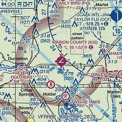
| Sectional chart |
|---|
|
| Airport distance calculator |
|---|
|
|
| Sunrise and sunset |
|---|
|
Times for 10-Dec-2025
| | Local
(UTC-5) | | Zulu
(UTC) |
|---|
| Morning civil twilight | | 06:47 | | 11:47 |
| Sunrise | | 07:13 | | 12:13 |
| Sunset | | 17:31 | | 22:31 |
| Evening civil twilight | | 17:57 | | 22:57 |
|
| Current date and time |
|---|
| Zulu (UTC) | 10-Dec-2025 05:48:41 |
|---|
| Local (UTC-5) | 10-Dec-2025 00:48:41 |
|---|
|
| METAR |
|---|
KOCF
10nm NE | 100451Z AUTO 01005KT 10SM SCT011 OVC050 10/08 A3009 RMK AO2 SLP190 T01000083
|
KCGC
16nm SW | 100535Z AUTO 04004KT 10SM SCT044 OVC049 11/08 A3007 RMK AO2
|
KINF
16nm S | 100535Z AUTO 01006KT 7SM BKN011 BKN039 OVC049 11/10 A3007 RMK AO2
|
KX60
18nm N | 118.425 352-528-9949
100535Z AUTO 02005KT 10SM OVC011 09/07 A3009 RMK AO2 T00920073
|
|
| TAF |
|---|
KLEE
33nm SE | 091726Z 0918/1018 04008KT P6SM FEW050 FM100500 35005KT P6SM SCT050 SCT300 FM101500 02006KT P6SM FEW040
|
KGNV
39nm N | 100421Z 1004/1024 02005KT P6SM BKN015 BKN050 TEMPO 1005/1008 SCT015 BKN050 FM100800 00000KT 6SM BR FEW005 BKN020 TEMPO 1009/1013 3SM BR BKN005 FM101400 33006KT P6SM FEW025 FM101600 27006KT P6SM SKC
|
|
| NOTAMs |
|---|
NOTAMs are issued by the DoD/FAA and will open in a separate window not controlled by AirNav.
|
|


