FAA INFORMATION EFFECTIVE 25 DECEMBER 2025
Location
| FAA Identifier: | 01U |
| Lat/Long: | 38-51-11.7000N 115-38-04.8000W
38-51.195000N 115-38.080000W
38.8532500,-115.6346667
(estimated) |
| Elevation: | 5133 ft. / 1564.5 m (surveyed) |
| Variation: | 15E (1985) |
| From city: | 6 miles SE of DUCKWATER, NV |
| Time zone: | UTC -8 (UTC -7 during Daylight Saving Time) |
| Zip code: | 89314 |
Airport Operations
| Airport use: | Open to the public |
| Activation date: | 08/1964 |
| Control tower: | no |
| ARTCC: | SALT LAKE CITY CENTER |
| FSS: | RENO FLIGHT SERVICE STATION |
| NOTAMs facility: | RNO (NOTAM-D service available) |
| Attendance: | UNATNDD |
| Wind indicator: | no |
| Segmented circle: | no |
Airport Communications
Airport Services
| Parking: | tiedowns |
| Airframe service: | NONE |
| Powerplant service: | NONE |
| Bottled oxygen: | NONE |
| Bulk oxygen: | NONE |
Runway Information
Runway 15/33
| Dimensions: | 3400 x 80 ft. / 1036 x 24 m |
| Surface: | dirt, in fair condition |
| RUNWAY 15 | | RUNWAY 33 |
| Latitude: | 38-51.541758N | | 38-50.993515N |
| Longitude: | 115-38.247048W | | 115-38.099483W |
| Elevation: | 5133.0 ft. | | 5108.0 ft. |
| Traffic pattern: | left | | left |
| Runway heading: | 153 magnetic, 168 true | | 333 magnetic, 348 true |
| Markings: | none | | none |
| Obstructions: | 15 ft. road, 30 ft. from runway, 2:1 slope to clear
11PLINE 1500 FT FROM RY END 35 FT, BOTH SIDES OF CNTRLN, MKD W/ ORANGE BALL, 42:1 SLOPE. | | none |
Runway 3/21
| Dimensions: | 2700 x 75 ft. / 823 x 23 m |
| Surface: | dirt, in fair condition |
| RUNWAY 3 | | RUNWAY 21 |
| Latitude: | 38-50.939367N | | 38-51.270198N |
| Longitude: | 115-38.152457W | | 115-37.772030W |
| Elevation: | 5105.0 ft. | | 5124.0 ft. |
| Traffic pattern: | left | | left |
| Runway heading: | 027 magnetic, 042 true | | 207 magnetic, 222 true |
| Markings: | none | | none |
| Obstructions: | 15 ft. road, 47 ft. right of centerline
PLINE 400 FT FROM RY END, +20 FT, BOTH SIDES OF CNTRLN, MARKED W/ORANGE BALL, 20:1 SLOPE. | | 15 ft. road, 47 ft. left of centerline |
Airport Ownership and Management from official FAA records
| Ownership: | Publicly-owned |
| Owner: | US BLM
5665 MORGAN MILL ROAD
CARSON CITY, NV 89701
Phone 775-885-6162 |
| Manager: | UNKNOWN |
Additional Remarks
| - | WATCH FOR LIVESTOCK ON RWYS. |
| - | RYS 03/21 & 15/33 HAVE UNCONTROLLED VEH ACCESS. |
| - | RY 03/21 +1 FT BERM FULL LENGTH NORTH SIDE, -2 FT DITCH FULL LENGTH SOUTH SIDE. |
| - | RY 15/33 +1 FT BERM BOTH SIDES OF RY. |
| - | RY 3, 2 STAKES N EDGE OF RY, 135 FT FROM RY END, +4 FT HIGH. |
| - | FOR CD CTC SALT LAKE ARTCC AT 801-320-2568. |
Instrument Procedures
There are no published instrument procedures at 01U.
Some nearby airports with instrument procedures:
KELY - Ely Airport/Yelland Field (46 nm NE)
05U - Eureka Airport (48 nm N)
KTNX - Tonopah Test Range Airport (83 nm SW)
KTPH - Tonopah Airport (83 nm SW)
|
|

Road maps at:
MapQuest
Bing
Google
| Aerial photo |
|---|

|
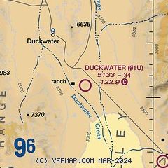
| Sectional chart |
|---|
|
| Airport distance calculator |
|---|
|
|
| Sunrise and sunset |
|---|
|
Times for 11-Jan-2026
| | Local
(UTC-8) | | Zulu
(UTC) |
|---|
| Morning civil twilight | | 06:32 | | 14:32 |
| Sunrise | | 07:02 | | 15:02 |
| Sunset | | 16:39 | | 00:39 |
| Evening civil twilight | | 17:09 | | 01:09 |
|
| Current date and time |
|---|
| Zulu (UTC) | 12-Jan-2026 00:58:53 |
|---|
| Local (UTC-8) | 11-Jan-2026 16:58:53 |
|---|
|
| METAR |
|---|
KELY
45nm NE | 120053Z AUTO 09003KT 10SM CLR M02/M06 A3048 RMK AO2 SLP371 T10221061 TSNO $
|
KP68
48nm N | 120053Z AUTO 28003KT M03/M09 A3049 RMK AO1 SLP367 T10331094
|
K05U
48nm N | 120035Z AUTO 00000KT 10SM CLR 01/M08 A3050 RMK A01
|
|
| TAF |
|---|
KELY
45nm NE | 111720Z 1118/1218 18009KT P6SM SCT250 FM111900 36008KT P6SM SCT250 FM120200 18009KT P6SM SCT250
|
|
| NOTAMs |
|---|
NOTAMs are issued by the DoD/FAA and will open in a separate window not controlled by AirNav.
|
|

