FAA INFORMATION EFFECTIVE 15 MAY 2025
Location
| FAA Identifier: | 1Y5 |
| Lat/Long: | 43-05-13.9050N 092-20-35.6370W
43-05.231750N 092-20.593950W
43.0871958,-92.3432325
(estimated) |
| Elevation: | 1173 ft. / 357.5 m (surveyed) |
| Variation: | 03E (1985) |
| From city: | 2 miles NW of NEW HAMPTON, IA |
| Time zone: | UTC -5 (UTC -6 during Standard Time) |
| Zip code: | 50659 |
Airport Operations
| Airport use: | Open to the public |
| Activation date: | 06/1947 |
| Control tower: | no |
| ARTCC: | MINNEAPOLIS CENTER |
| FSS: | FORT DODGE FLIGHT SERVICE STATION |
| NOTAMs facility: | FOD (NOTAM-D service available) |
| Attendance: | UNATNDD |
| Wind indicator: | yes |
| Segmented circle: | no |
Airport Communications
| CTAF: | 122.9 |
| WX AWOS-3 at CCY (12 nm W): | 125.525 (641-228-7069) |
Nearby radio navigation aids
| VOR radial/distance | | VOR name | | Freq | | Var |
|---|
| ALOr004/31.9 | | WATERLOO VOR/DME | | 112.20 | | 00E |
Airport Services
| Parking: | tiedowns |
| Airframe service: | NONE |
| Powerplant service: | NONE |
| Bottled oxygen: | NONE |
| Bulk oxygen: | NONE |
Runway Information
Runway 17/35
| Dimensions: | 2900 x 50 ft. / 884 x 15 m |
| Surface: | asphalt, in good condition |
| Weight bearing capacity: | |
| RUNWAY 17 | | RUNWAY 35 |
| Latitude: | 43-05.524667N | | 43-05.056000N |
| Longitude: | 092-20.685833W | | 092-20.562833W |
| Elevation: | 1173.0 ft. | | 1167.0 ft. |
| Traffic pattern: | left | | left |
| Markings: | basic, in good condition | | basic, in good condition |
| Obstructions: | 44 ft. tree, 716 ft. from runway, 165 ft. right of centerline, 11:1 slope to clear | | 10 ft. road, 500 ft. from runway, 30:1 slope to clear |
Runway 4/22
| Dimensions: | 2300 x 105 ft. / 701 x 32 m |
| Surface: | turf, in fair condition |
| Runway edge markings: | RYS 04 & 22 THLD & EDGES MARKED WITH YELLOW CONES. |
| RUNWAY 4 | | RUNWAY 22 |
| Traffic pattern: | left | | left |
| Obstructions: | 20 ft. pole, 520 ft. from runway, 20 ft. right of centerline, 26:1 slope to clear | | 15 ft. road, 550 ft. from runway, 36:1 slope to clear |
Airport Ownership and Management from official FAA records
| Ownership: | Publicly-owned |
| Owner: | CITY OF NEW HAMPTON
112 EAST SPRING
NEW HAMPTON, IA 50659
Phone 641-394-5906 |
| Manager: | BRODIE RETHAMEL
515 GARFIELD STREET
NEW HAMPTON, IA 50659
Phone (641) 330-2448
ARPT COMM. |
Additional Remarks
| - | RC ACFT OPNS IN AREA. |
| - | RY 17 IS CALM WIND RY. |
| - | ARPT CLSD FOR NIGHT OPNS. |
| - | FOR CD CTC WATERLOO APCH 319-233-4835. WHEN WATERLOO APCH CLSD, FOR CD CTC MINNEAPOLIS ARTCC AT 651-463-5588. |
| - | SNOW REMOVAL DELAYED AT TIMES; CONFIRM RWY COND PRIOR TO USE. |
Instrument Procedures
There are no published instrument procedures at 1Y5.
Some nearby airports with instrument procedures:
KCCY - Northeast Iowa Regional Airport (12 nm W)
KCJJ - Ellen Church Field Airport (19 nm NE)
C25 - Waverly Municipal Airport (22 nm S)
3Y2 - George L Scott Municipal Airport (25 nm E)
KDEH - Decorah Municipal Airport (29 nm NE)
|
|

Road maps at:
MapQuest
Bing
Google
| Aerial photo |
|---|
WARNING: Photo may not be current or correct

Do you have a better or more recent aerial photo of New Hampton Municipal Airport that you would like to share? If so, please send us your photo.
|
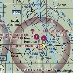
| Sectional chart |
|---|
|
| Airport distance calculator |
|---|
|
|
| Sunrise and sunset |
|---|
|
Times for 09-Jun-2025
| | Local
(UTC-5) | | Zulu
(UTC) |
|---|
| Morning civil twilight | | 04:56 | | 09:56 |
| Sunrise | | 05:31 | | 10:31 |
| Sunset | | 20:46 | | 01:46 |
| Evening civil twilight | | 21:21 | | 02:21 |
|
| Current date and time |
|---|
| Zulu (UTC) | 09-Jun-2025 06:04:56 |
|---|
| Local (UTC-5) | 09-Jun-2025 01:04:56 |
|---|
|
| METAR |
|---|
KCCY
12nm W | 090555Z AUTO 21012KT 10SM FEW095 14/11 A2965 RMK AO2
|
|
| TAF |
|---|
KALO
32nm S | 090520Z 0906/1006 23009KT P6SM FEW240 FM090900 25010KT P6SM BKN120 FM091500 30014G25KT P6SM BKN035 FM100000 30013KT P6SM SCT110
|
|
| NOTAMs |
|---|
NOTAMs are issued by the DoD/FAA and will open in a separate window not controlled by AirNav.
|
|


