FAA INFORMATION EFFECTIVE 27 NOVEMBER 2025
Location
| FAA Identifier: | 2A1 |
| Lat/Long: | 36-20-58.9330N 084-56-47.9520W
36-20.982217N 084-56.799200W
36.3497036,-84.9466533
(estimated) |
| Elevation: | 1694.3 ft. / 516.4 m (surveyed) |
| Variation: | 05W (2020) |
| From city: | 5 miles S of JAMESTOWN, TN |
| Time zone: | UTC -6 (UTC -5 during Daylight Saving Time) |
| Zip code: | 38556 |
Airport Operations
| Airport use: | Open to the public |
| Control tower: | no |
| ARTCC: | INDIANAPOLIS CENTER |
| FSS: | NASHVILLE FLIGHT SERVICE STATION |
| NOTAMs facility: | BNA (NOTAM-D service available) |
| Attendance: | MON-SUN 0800-1600 |
| Wind indicator: | lighted |
| Segmented circle: | yes |
| Lights: | ACTVT REIL RWY 01 & 19; MIRL 01/19 - CTAF. MIRL 01/19 INCR INTST - CTAF. PAPI RWY 01 & 19 ON CONSLY. |
| Beacon: | white-green (lighted land airport)
Operates sunset to sunrise. |
Airport Communications
| CTAF/UNICOM: | 122.8 |
| WX AWOS-3 at 8A3 (18 nm W): | 126.175 (931-823-3329) |
| WX AWOS-3 at SCX (19 nm E): | 135.025 (423-569-6651) |
- APCH/DEP SVC PRVDD BY INDIANAPOLIS ARTCC ON FREQS 124.625/371.925 (LONDON 2 RCAG).
Nearby radio navigation aids
| VOR radial/distance | | VOR name | | Freq | | Var |
|---|
| LVTr145/17.6 | | LIVINGSTON VOR/DME | | 114.35 | | 02W |
| HCHr005/34.2 | | HINCH MOUNTAIN VOR/DME | | 117.60 | | 02W |
| NDB name | | Hdg/Dist | | Freq | | Var | | ID |
|---|
| HUCHN | | 058/37.8 | | 233 | | 03W | | HEM | .... . -- |
Airport Services
| Fuel available: | 100LL |
| Parking: | hangars and tiedowns |
| Airframe service: | NONE |
| Powerplant service: | MAJOR |
Runway Information
Runway 1/19
| Dimensions: | 3498 x 75 ft. / 1066 x 23 m |
| Surface: | concrete, in excellent condition |
| Weight bearing capacity: | | Single wheel: | 17.0 | | Double wheel: | 22.0 |
|
| Runway edge lights: | medium intensity |
| RUNWAY 1 | | RUNWAY 19 |
| Latitude: | 36-20.693990N | | 36-21.270450N |
| Longitude: | 084-56.801548W | | 084-56.796857W |
| Elevation: | 1678.6 ft. | | 1694.3 ft. |
| Traffic pattern: | left | | left |
| Runway heading: | 005 magnetic, 000 true | | 185 magnetic, 180 true |
| Markings: | nonprecision, in fair condition | | nonprecision, in fair condition |
| Visual slope indicator: | 4-light PAPI on left (4.00 degrees glide path) | | 4-light PAPI on left (4.00 degrees glide path) |
| Runway end identifier lights: | yes | | yes |
| Touchdown point: | yes, no lights | | yes, no lights |
| Obstructions: | 88 ft. tree, 1528 ft. from runway, 419 ft. left of centerline, 15:1 slope to clear | | 55 ft. tree, 1277 ft. from runway, 170 ft. left of centerline, 19:1 slope to clear |
Airport Ownership and Management from official FAA records
| Ownership: | Publicly-owned |
| Owner: | CITY OF JAMESTOWN
CITY HALL PO BOX 670
JAMESTOWN, TN 38556
Phone 931-879-8815 |
| Manager: | RONNIE SEAGRAVES
125 AIRPORT RD
JAMESTOWN, TN 38556
Phone 931-879-8948
AFT HR - 931-879-5685. |
Additional Remarks
| - | FOR CD CTC INDIANAPOLIS ARTCC AT 317-247-2411. |
Instrument Procedures
NOTE: All procedures below are presented as PDF files. If you need a reader for these files, you should download the free Adobe Reader.NOT FOR NAVIGATION. Please procure official charts for flight.
FAA instrument procedures published for use from 27 November 2025 at 0901Z to 25 December 2025 at 0900Z.
IAPs - Instrument Approach Procedures |
|---|
| RNAV (GPS)-B | |
download (182KB) |
| RNAV (GPS)-C | |
download (202KB) |
| NOTE: Special Take-Off Minimums/Departure Procedures apply | |
download (359KB) |
Other nearby airports with instrument procedures:
8A3 - Livingston Municipal Airport (18 nm W)
KSCX - Scott Municipal Airport (19 nm E)
KCSV - Crossville Memorial Airport-Whitson Field (25 nm S)
KRKW - Rockwood Municipal Airport (29 nm SE)
KEKQ - Wayne County Airport (31 nm N)
|
|

Road maps at:
MapQuest
Bing
Google
| Aerial photo |
|---|
WARNING: Photo may not be current or correct
 Photo by Marc Mueller
Do you have a better or more recent aerial photo of Jamestown Municipal Airport that you would like to share? If so, please send us your photo.
|
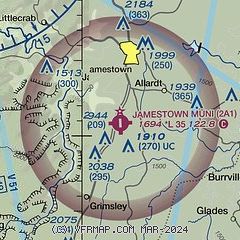
| Sectional chart |
|---|
|
| Airport distance calculator |
|---|
|
|
| Sunrise and sunset |
|---|
|
Times for 15-Dec-2025
| | Local
(UTC-6) | | Zulu
(UTC) |
|---|
| Morning civil twilight | | 06:16 | | 12:16 |
| Sunrise | | 06:45 | | 12:45 |
| Sunset | | 16:25 | | 22:25 |
| Evening civil twilight | | 16:54 | | 22:54 |
|
| Current date and time |
|---|
| Zulu (UTC) | 15-Dec-2025 11:52:40 |
|---|
| Local (UTC-6) | 15-Dec-2025 05:52:40 |
|---|
|
| METAR |
|---|
K8A3
18nm W | 151135Z AUTO 06004KT 10SM CLR M13/M16 A3045 RMK A01
|
KSCX
19nm E | 151135Z AUTO 03005KT 10SM CLR M14/M16 A3044 RMK A01
|
KCSV
25nm S | 151053Z AUTO 09006KT 10SM CLR M12/M16 A3040 RMK AO2 SLP326 T11221156 FZRANO
|
KRKW
29nm SE | 151135Z AUTO 00000KT 10SM CLR M12/M16 A3045 RMK A01
|
KEKQ
31nm N | 151056Z AUTO 04005KT 10SM CLR M13/M16 A3055 RMK AO2 SLP363 T11331156 PNO $
|
KSRB
33nm SW | 151130Z AUTO 00000KT 10SM CLR M12/M14 A3048 RMK AO2
|
|
| NOTAMs |
|---|
NOTAMs are issued by the DoD/FAA and will open in a separate window not controlled by AirNav.
|
|

