FAA INFORMATION EFFECTIVE 27 NOVEMBER 2025
Location
| FAA Identifier: | 33R |
| Lat/Long: | 31-05-03.6000N 095-09-50.8000W
31-05.060000N 095-09.846667W
31.0843333,-95.1641111
(estimated) |
| Elevation: | 340 ft. / 104 m (estimated) |
| Variation: | 06E (1985) |
| From city: | 3 miles NW of GROVETON, TX |
| Time zone: | UTC -6 (UTC -5 during Daylight Saving Time) |
| Zip code: | 75845 |
Airport Operations
| Airport use: | Open to the public |
| Activation date: | 01/1970 |
| Control tower: | no |
| ARTCC: | HOUSTON CENTER |
| FSS: | MONTGOMERY COUNTY FLIGHT SERVICE STATION |
| NOTAMs facility: | CXO (NOTAM-D service available) |
| Attendance: | UNATNDD |
| Wind indicator: | lighted |
| Segmented circle: | yes |
| Lights: | ACTVT LIRL RY 16/34 - CTAF. |
| Beacon: | white-green (lighted land airport)
Operates sunset to sunrise. |
Airport Communications
| CTAF: | 122.9 |
| WX AWOS-3PT at DKR (18 nm NW): | 118.775 (936-545-8510) |
Nearby radio navigation aids
| VOR radial/distance | | VOR name | | Freq | | Var |
|---|
| LFKr253/23.4 | | LUFKIN VORTAC | | 112.10 | | 05E |
Airport Services
| Parking: | tiedowns |
| Airframe service: | NONE |
| Powerplant service: | NONE |
| Bottled oxygen: | NONE |
| Bulk oxygen: | NONE |
Runway Information
Runway 16/34
| Dimensions: | 3500 x 60 ft. / 1067 x 18 m |
| Surface: | asphalt, in good condition |
| Weight bearing capacity: | |
| Runway edge lights: | low intensity |
| RUNWAY 16 | | RUNWAY 34 |
| Latitude: | 31-05.340098N | | 31-04.780272N |
| Longitude: | 095-09.929040W | | 095-09.764457W |
| Elevation: | 333.0 ft. | | 338.0 ft. |
| Traffic pattern: | left | | left |
| Runway heading: | 160 magnetic, 166 true | | 340 magnetic, 346 true |
| Markings: | basic, in good condition | | basic, in good condition |
| Obstructions: | 100 ft. trees, 2260 ft. from runway, 330 ft. left and right of centerline, 20:1 slope to clear | | 75 ft. trees, 1415 ft. from runway, 270 ft. left and right of centerline, 16:1 slope to clear |
Airport Ownership and Management from official FAA records
| Ownership: | Publicly-owned |
| Owner: | GROVETON CITY-TRINITY COUNTY
TRINITY COUNTY COURT HOUSE, 162 WEST FIRST STREET
GROVETON, TX 75845
Phone 936-642-1746
CITY OF GROVETON, 115 W FRONT ST, GROVETON, TX, 936-642-1122. |
| Manager: | JUDGE DANNY MARTIN
TRINITY COUNTY COURTHOUSE, 162 WEST FIRST STREET
GROVETON, TX 75845
Phone 936-642-1746
FACILITIES MGR BECKY DAVIS 936-707-7164, FACILITIES@CO.TRINITY.TX.US. |
Additional Remarks
| - | DEER AND FERAL HOGS ON & INVOF ARPT. |
| - | FOR CD CTC HOUSTON ARTCC AT 281-230-5622. |
Instrument Procedures
There are no published instrument procedures at 33R.
Some nearby airports with instrument procedures:
KDKR - Houston County Airport (18 nm NW)
KLFK - Angelina County Airport (23 nm NE)
00R - Livingston Municipal Airport (25 nm S)
KUTS - Huntsville Municipal Airport (30 nm SW)
KOCH - Nacogdoches A L Mangham Jr. Regional Airport (38 nm NE)
|
|

Road maps at:
MapQuest
Bing
Google
| Aerial photo |
|---|
WARNING: Photo may not be current or correct
 Photo by Danny Schnautz
Photo taken 11-May-2018
looking northwest.
Photo by Danny Schnautz
Photo taken 11-May-2018
looking northwest.
Do you have a better or more recent aerial photo of Groveton/Trinity County Airport that you would like to share? If so, please send us your photo.
|
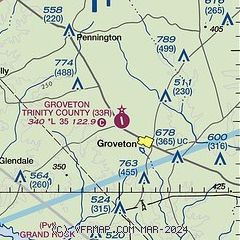
| Sectional chart |
|---|
|
| Airport distance calculator |
|---|
|
|
| Sunrise and sunset |
|---|
|
Times for 23-Dec-2025
| | Local
(UTC-6) | | Zulu
(UTC) |
|---|
| Morning civil twilight | | 06:50 | | 12:50 |
| Sunrise | | 07:17 | | 13:17 |
| Sunset | | 17:23 | | 23:23 |
| Evening civil twilight | | 17:49 | | 23:49 |
|
| Current date and time |
|---|
| Zulu (UTC) | 23-Dec-2025 16:21:45 |
|---|
| Local (UTC-6) | 23-Dec-2025 10:21:45 |
|---|
|
| METAR |
|---|
KDKR
18nm NW | 231555Z AUTO 17009KT 7SM BKN011 22/22 A3029 RMK AO2
|
KLFK
23nm NE | 231553Z AUTO 15008KT 10SM OVC007 21/19 A3031 RMK AO2 SLP259 T02060189
|
KUTS
29nm SW | 231553Z AUTO 20009G15KT 10SM OVC013 23/19 A3030 RMK AO1 SLP254 T02280194
|
|
| TAF |
|---|
KLFK
23nm NE | 231123Z 2312/2412 15005KT P6SM SCT015 OVC030 TEMPO 2312/2316 BKN015 FM231600 17008KT P6SM BKN035 TEMPO 2316/2318 BKN030 FM232000 18008KT P6SM SCT040 FM240000 15006KT P6SM FEW040 FM240600 15004KT P6SM BKN010
|
|
| NOTAMs |
|---|
NOTAMs are issued by the DoD/FAA and will open in a separate window not controlled by AirNav.
|
|

