FAA INFORMATION EFFECTIVE 14 MAY 2026
Location
| FAA Identifier: | 3F6 |
| Lat/Long: | 34-01-39.4790N 100-16-55.2090W
34-01.657983N 100-16.920150W
34.0276331,-100.2820025
(estimated) |
| Elevation: | 1859.5 ft. / 566.8 m (surveyed) |
| Variation: | 05E (2020) |
| From city: | 1 mile E of PADUCAH, TX |
| Time zone: | UTC -5 (UTC -6 during Standard Time) |
| Zip code: | 79248 |
Airport Operations
| Airport use: | Open to the public |
| Control tower: | no |
| ARTCC: | FORT WORTH CENTER |
| FSS: | FORT WORTH FLIGHT SERVICE STATION |
| NOTAMs facility: | FTW (NOTAM-D service available) |
| Attendance: | UNATNDD |
| Wind indicator: | lighted |
| Segmented circle: | yes |
| Lights: | MIRL RWY 18/36 PRESET LOW INTST; TO INCR INTST ACTVT - CTAF. |
| Beacon: | white-green (lighted land airport)
Operates sunset to sunrise. |
Airport Communications
- APCH/DEP CTL SVC PRVDD BY FORT WORTH ARTCC (ZFW) ON FREQS 133.5/350.35 (PADUCAH RCAG).
Nearby radio navigation aids
| VOR radial/distance | | VOR name | | Freq | | Var |
|---|
| CDSr169/20.5 | | CHILDRESS VORTAC | | 117.00 | | 10E |
Airport Services
| Parking: | tiedowns |
| Bottled oxygen: | NONE |
| Bulk oxygen: | NONE |
Runway Information
Runway 18/36
| Dimensions: | 3186 x 50 ft. / 971 x 15 m |
| Surface: | asphalt, in fair condition |
| Weight bearing capacity: | |
| Runway edge lights: | medium intensity |
| RUNWAY 18 | | RUNWAY 36 |
| Latitude: | 34-01.921217N | | 34-01.395983N |
| Longitude: | 100-16.920700W | | 100-16.920100W |
| Elevation: | 1858.6 ft. | | 1850.1 ft. |
| Traffic pattern: | left | | left |
| Runway heading: | 175 magnetic, 180 true | | 355 magnetic, 360 true |
| Markings: | nonprecision, in good condition | | nonprecision, in good condition |
| Touchdown point: | yes, no lights | | yes, no lights |
| Obstructions: | none
4 FT FENCE AT THR 100 FT RIGHT. | | 5 ft. berm, 200 ft. from runway, 90 ft. left of centerline
5 FT BERM 90 FT L AT THLD; 5 FT FENCE 93 FT WEST OF CENTERLINE AT THLD. |
Helipad H1
| Dimensions: | 25 x 25 ft. / 8 x 8 m |
| Surface: | asphalt, in poor condition
NOT MAINTAINED. LOOSE GRAVEL AND GRASS ENCROACHMENT ON SURFACE. |
| Latitude: | 34-01.660333N | | |
| Longitude: | 100-16.869167W | | |
| Elevation: | 1859.5 ft. | | |
| Traffic pattern: | left | | left |
| Markings: | none, in poor condition | | |
Airport Ownership and Management from official FAA records
| Ownership: | Publicly-owned |
| Owner: | CITY OF PADUCAH & COTTLE CO
815 9TH STREET, PO BOX 759
PADUCAH, TX 79248
Phone 806-492-3613 |
| Manager: | KARL HOLLOWAY
815 9TH STREET, PO BOX 729
PADUCAH, TX 79248
Phone 806-492-3613
COUNTY JUDGE. |
Additional Remarks
| A57-H1 | APCH RATIO FM EAST 8:1; APCH RATIO FM WEST CROSSES CNTRLN OF RY 17/35. |
| - | RWY 18, 10 FT DROP OFF 60 FT DSTC. |
| - | FOR CD CTC FORT WORTH ARTCC AT 817-858-7584. |
| - | RWY 18/36 MARKED AS 17/35. |
| A52-H1 | 20 FT LGTD WINDSOCK 165 FT NE; 30 FT PLINE 267 FT E; 20 FT BLDG 240 FT SE. |
Instrument Procedures
NOTE: All procedures below are presented as PDF files. If you need a reader for these files, you should download the free Adobe Reader.NOT FOR NAVIGATION. Please procure official charts for flight.
FAA instrument procedures published for use from 14 May 2026 at 0901Z to 11 June 2026 at 0900Z.
IAPs - Instrument Approach Procedures |
|---|
| RNAV (GPS) RWY 36 | |
download (159KB) |
| NOTE: Special Take-Off Minimums/Departure Procedures apply | |
download (217KB) |
Other nearby airports with instrument procedures:
KCDS - Childress Municipal Airport (24 nm N)
O35 - Hollis Municipal Airport (45 nm NE)
F05 - Wilbarger County Airport (51 nm E)
41F - Floydada Municipal Airport (52 nm W)
8F3 - Crosbyton Municipal Airport (54 nm SW)
|
|

Road maps at:
MapQuest
Bing
Google
| Aerial photo |
|---|

|
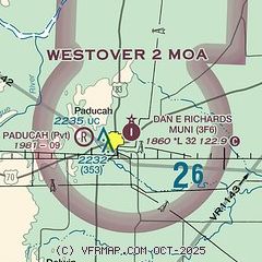
| Sectional chart |
|---|
|
| Airport distance calculator |
|---|
|
|
| Sunrise and sunset |
|---|
|
Times for 17-May-2026
| | Local
(UTC-5) | | Zulu
(UTC) |
|---|
| Morning civil twilight | | 06:11 | | 11:11 |
| Sunrise | | 06:39 | | 11:39 |
| Sunset | | 20:36 | | 01:36 |
| Evening civil twilight | | 21:04 | | 02:04 |
|
| Current date and time |
|---|
| Zulu (UTC) | 17-May-2026 10:42:02 |
|---|
| Local (UTC-5) | 17-May-2026 05:42:02 |
|---|
|
| METAR |
|---|
KCDS
24nm N | 170953Z AUTO 20011KT 10SM CLR 23/18 A2966 RMK AO2 SLP013 T02280178
|
|
| TAF |
|---|
KCDS
24nm N | 170520Z 1706/1806 19015G25KT P6SM FEW100 FM172000 17020G30KT P6SM FEW250
|
|
| NOTAMs |
|---|
NOTAMs are issued by the DoD/FAA and will open in a separate window not controlled by AirNav.
|
|

