FAA INFORMATION EFFECTIVE 09 JULY 2026
Location
| FAA Identifier: | 8F3 |
| Lat/Long: | 33-37-25.8000N 101-14-27.1000W
33-37.430000N 101-14.451667W
33.6238333,-101.2408611
(estimated) |
| Elevation: | 3018.1 ft. / 919.9 m (surveyed) |
| Variation: | 08E (1980) |
| From city: | 2 miles S of CROSBYTON, TX |
| Time zone: | UTC -5 (UTC -6 during Standard Time) |
| Zip code: | 79322 |
Airport Operations
| Airport use: | Open to the public |
| Activation date: | 05/1975 |
| Control tower: | no |
| ARTCC: | FORT WORTH CENTER |
| FSS: | FORT WORTH FLIGHT SERVICE STATION |
| NOTAMs facility: | FTW (NOTAM-D service available) |
| Attendance: | UNATNDD |
| Wind indicator: | lighted |
| Segmented circle: | yes |
| Lights: | ACTVT MIRL RWY 17/35 - CTAF; OPR ON STEP 1 ONLY. |
| Beacon: | white-green (lighted land airport)
Operates sunset to sunrise. |
Airport Communications
| CTAF/UNICOM: | 122.8 |
| LUBBOCK APPROACH: | 119.2 119.9 |
| LUBBOCK DEPARTURE: | 119.2 119.9 |
Nearby radio navigation aids
| VOR radial/distance | | VOR name | | Freq | | Var |
|---|
| LBBr087/34.0 | | LUBBOCK VORTAC | | 109.20 | | 11E |
| PVWr124/39.0 | | PLAINVIEW VOR/DME | | 112.90 | | 11E |
Airport Services
Runway Information
Runway 17/35
| Dimensions: | 3600 x 60 ft. / 1097 x 18 m |
| Surface: | asphalt, in fair condition |
| Weight bearing capacity: | |
| Runway edge lights: | medium intensity |
| Runway edge markings: | MARKINGS FADED, NRS MISSING. |
| RUNWAY 17 | | RUNWAY 35 |
| Latitude: | 33-37.726843N | | 33-37.133330N |
| Longitude: | 101-14.450913W | | 101-14.450948W |
| Elevation: | 3018.0 ft. | | 3012.5 ft. |
| Traffic pattern: | left | | left |
| Runway heading: | 172 magnetic, 180 true | | 352 magnetic, 360 true |
| Markings: | basic, in poor condition | | basic, in poor condition |
| Visual slope indicator: | 2-box VASI on left (4.00 degrees glide path)
VASI OTS INDEFLY. | | 2-box VASI on left (4.00 degrees glide path)
VASI OTS INDEFLY. |
| Touchdown point: | yes, no lights | | yes, no lights |
| Obstructions: | 38 ft. pline, lighted, 825 ft. from runway, 275 ft. right of centerline, 16:1 slope to clear | | 15 ft. trees, 420 ft. from runway, 210 ft. right of centerline, 14:1 slope to clear |
Airport Ownership and Management from official FAA records
| Ownership: | Publicly-owned |
| Owner: | CITY OF CROSBYTON
221 W MAIN
CROSBYTON, TX 79322
Phone 806-675-2301 |
| Manager: | AMY WALLACE
P.O. BOX 1187, 221 W MAIN
RALLS, TX 79357
Phone 806-790-8533
CITY/AIRPORT MGR. |
Additional Remarks
| - | WINDSOCK LGT OTS INDEFLY. |
| - | FOR CD CTC FORT WORTH ARTCC AT 817-858-7584. |
| - | SEASONAL AERIAL AG ACTVTY. |
Instrument Procedures
NOTE: All procedures below are presented as PDF files. If you need a reader for these files, you should download the free Adobe Reader.NOT FOR NAVIGATION. Please procure official charts for flight.
FAA instrument procedures published for use from 09 July 2026 at 0901Z to 06 August 2026 at 0900Z.
IAPs - Instrument Approach Procedures |
|---|
| RNAV (GPS) RWY 17 | |
download (184KB) |
| RNAV (GPS) RWY 35 | |
download (221KB) |
| NOTE: Special Take-Off Minimums/Departure Procedures apply | |
download (165KB) |
Other nearby airports with instrument procedures:
F49 - City of Slaton/Larry T Neal Memorial Airport (23 nm W)
41F - Floydada Municipal Airport (23 nm N)
KLBB - Lubbock Preston Smith International Airport (29 nm W)
F82 - Lubbock Executive Airpark (30 nm W)
KPVW - Hale County Airport (40 nm NW)
|
|

Road maps at:
MapQuest
Bing
Google
| Aerial photo |
|---|

|
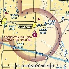
| Sectional chart |
|---|
|
| Airport distance calculator |
|---|
|
|
| Sunrise and sunset |
|---|
|
Times for 18-Jul-2026
| | Local
(UTC-5) | | Zulu
(UTC) |
|---|
| Morning civil twilight | | 06:20 | | 11:20 |
| Sunrise | | 06:49 | | 11:49 |
| Sunset | | 20:54 | | 01:54 |
| Evening civil twilight | | 21:22 | | 02:22 |
|
| Current date and time |
|---|
| Zulu (UTC) | 19-Jul-2026 03:08:32 |
|---|
| Local (UTC-5) | 18-Jul-2026 22:08:32 |
|---|
|
| METAR |
|---|
KLBB
29nm W | 190253Z 18010KT 10SM SCT075 SCT100 BKN130 BKN250 24/18 A3007 RMK AO2 SLP133 OCNL LTGIC DSNT SE FRQ LTGICCG DSNT SW CB DSNT SE AND SW MOV S 60000 T02390178 53018
|
KPVW
40nm NW | 190230Z AUTO 17005KT 10SM SCT070 SCT090 24/17 A3006 RMK AO2 T02360165
|
|
| TAF |
|---|
KLBB
29nm W | 190039Z 1901/1924 15008KT P6SM SCT060 FM190600 20008KT P6SM SCT100 FM191400 17008KT P6SM SCT250
|
|
| NOTAMs |
|---|
NOTAMs are issued by the DoD/FAA and will open in a separate window not controlled by AirNav.
|
|


