FAA INFORMATION EFFECTIVE 16 APRIL 2026
Location
| FAA Identifier: | 3J1 |
| Lat/Long: | 32-29-48.6620N 080-59-35.3360W
32-29.811033N 080-59.588933W
32.4968506,-80.9931489
(estimated) |
| Elevation: | 84.8 ft. / 25.8 m (surveyed) |
| Variation: | 04W (1985) |
| From city: | 1 mile NW of RIDGELAND, SC |
| Time zone: | UTC -4 (UTC -5 during Standard Time) |
| Zip code: | 29936 |
Airport Operations
| Airport use: | Open to the public |
| Activation date: | 12/1942 |
| Control tower: | no |
| ARTCC: | JACKSONVILLE CENTER |
| FSS: | ANDERSON FLIGHT SERVICE STATION |
| NOTAMs facility: | AND (NOTAM-D service available) |
| Attendance: | MON -SUN 0800-1800
SUN, MON - ON CALL. 843-929-4159 FOR AFTER HOURS FEE AND AVAIL.
SKYBLUE AVIATION FBO. |
| Wind indicator: | lighted |
| Segmented circle: | yes |
| Lights: | MIRL RWY 18/36 PRESET LOW INTST; TO INCR INTST CTAF. REIL RWY 18 & 36; PAPI RWY 18 & 36 OPR CONSLY DUSK-DAWN. |
| Beacon: | white-green (lighted land airport)
Operates sunset to sunrise. |
Airport Communications
| CTAF/UNICOM: | 123.075 |
| WX AWOS-3PT: | 118.450 (843-547-8419) |
| WX AWOS-3 at ARW (19 nm E): | 119.675 (843-524-1000) |
Nearby radio navigation aids
| VOR radial/distance | | VOR name | | Freq | | Var |
|---|
| SAVr032/23.5 | | SAVANNAH VORTAC | | 115.95 | | 06W |
| SVNr016/30.0 | | HUNTER VOR/DME | | 111.60 | | 02W |
| ALDr155/(34.4) | | ALLENDALE VOR | | 116.70 | | 01W |
| NDB name | | Hdg/Dist | | Freq | | Var | | ID |
|---|
| BULLO | | 087/34.3 | | 407 | | 05W | | BZQ | -... --.. --.- |
Airport Services
| Fuel available: | 100LL JET-A JET-A+
A+:JET A WITH PRIST. |
| Parking: | tiedowns |
| Airframe service: | MINOR |
| Powerplant service: | MINOR |
| Bottled oxygen: | NONE |
| Bulk oxygen: | NONE |
Runway Information
Runway 18/36
| Dimensions: | 4200 x 75 ft. / 1280 x 23 m |
| Surface: | asphalt, in excellent condition |
| Weight bearing capacity: | | Single wheel: | 30.0 | | Double wheel: | 45.0 |
|
| Runway edge lights: | medium intensity |
| RUNWAY 18 | | RUNWAY 36 |
| Latitude: | 32-30.156428N | | 32-29.465642N |
| Longitude: | 080-59.558953W | | 080-59.618908W |
| Elevation: | 84.8 ft. | | 74.9 ft. |
| Traffic pattern: | left | | left |
| Runway heading: | 188 magnetic, 184 true | | 008 magnetic, 004 true |
| Markings: | basic, in good condition | | basic, in good condition |
| Visual slope indicator: | 2-light PAPI on left (3.00 degrees glide path)
RWY 18 PAPI UNUSBL BYD 8 DEGS LEFT OF RCL. | | 2-light PAPI on left (3.00 degrees glide path) |
| Runway end identifier lights: | yes | | yes |
| Touchdown point: | yes, no lights | | yes, no lights |
Airport Ownership and Management from official FAA records
| Ownership: | Publicly-owned |
| Owner: | COUNTY OF JASPER
P.O. BOX 1149, 358 3RD AVENUE
RIDGELAND, SC 29936-8785
Phone (843) 717-3690 |
| Manager: | LEONARD SANSONE
1765 GRAYS HIGHWAY, PO BOX 653
RIDGELAND, SC 29936
Phone 843-226-0399 |
Additional Remarks
| A58-36 | TREE, 10 FT TALL, 166 FT FROM THRESHOLD, 125 FT LEFT OF CENTERLINE |
| A56-36 | 50 FT TREES 100-150 FT RIGHT OF CNTRLN 1000 FT FM THR. |
| - | GLIDER OPNS INVOF ARPT. |
| - | FOR CD CTC BEAUFORT APCH AT 843-228-6298, WHEN APCH CLSD CTC JACKSONVILLE ARTCC AT 904-845-1592. |
| - | FBO LCTD MID-FLD. |
| - | RWY 36 CALM WIND RWY. |
Instrument Procedures
There are no published instrument procedures at 3J1.
Some nearby airports with instrument procedures:
KNBC - Beaufort Marine Corps Air Station (Merritt Field) Airport (14 nm E)
KARW - Beaufort Executive Airport (19 nm E)
KHXD - Hilton Head Airport (22 nm SE)
KSAV - Savannah/Hilton Head International Airport (25 nm SW)
KSVN - Hunter Army Airfield (30 nm S)
|
|

Road maps at:
MapQuest
Bing
Google
| Aerial photo |
|---|
WARNING: Photo may not be current or correct
 Photo by H. Mikell Anderson
Photo taken 20-Nov-2020
looking south.
Photo by H. Mikell Anderson
Photo taken 20-Nov-2020
looking south.
Do you have a better or more recent aerial photo of Ridgeland-Claude Dean Airport that you would like to share? If so, please send us your photo.
|
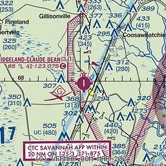
| Sectional chart |
|---|
|
| Airport distance calculator |
|---|
|
|
| Sunrise and sunset |
|---|
|
Times for 28-Apr-2026
| | Local
(UTC-4) | | Zulu
(UTC) |
|---|
| Morning civil twilight | | 06:15 | | 10:15 |
| Sunrise | | 06:41 | | 10:41 |
| Sunset | | 20:02 | | 00:02 |
| Evening civil twilight | | 20:28 | | 00:28 |
|
| Current date and time |
|---|
| Zulu (UTC) | 28-Apr-2026 07:32:51 |
|---|
| Local (UTC-4) | 28-Apr-2026 03:32:51 |
|---|
|
| METAR |
|---|
KNBC
14nm E | 280656Z AUTO 06004KT 10SM SCT033 15/12 A3015 RMK AO2 SLP211 T01500122
|
KHXD
22nm SE | 280715Z AUTO 04007KT 10SM OVC026 17/14 A3015 RMK AO2
|
KSAV
25nm SW | 280703Z AUTO 00000KT 10SM BKN024 BKN030 14/12 A3016 RMK AO2 T01440122
|
|
| TAF |
|---|
KNBC
14nm E | 280200Z 2803/2903 VRB05KT 9999 BKN022 QNH3012INS FM280800 VRB05KT 9999 SCT020 QNH3013INS BECMG 2815/2817 16006KT 9999 SCT035 BKN200 QNH3005INS FM282300 VRB03KT 9999 BKN060 BKN200 QNH3002INS TX28/2820Z TN14/2811Z
|
|
| NOTAMs |
|---|
NOTAMs are issued by the DoD/FAA and will open in a separate window not controlled by AirNav.
|
|


