FAA INFORMATION EFFECTIVE 22 JANUARY 2026
Location
| FAA Identifier: | 3TE |
| Lat/Long: | 42-01-30.3990N 083-56-21.4690W
42-01.506650N 083-56.357817W
42.0251108,-83.9392969
(estimated) |
| Elevation: | 812 ft. / 247 m (estimated) |
| Variation: | 07W (2015) |
| From city: | 2 miles N of TECUMSEH, MI |
| Time zone: | UTC -5 (UTC -4 during Daylight Saving Time) |
| Zip code: | 49286 |
Airport Operations
| Airport use: | Open to the public |
| Activation date: | 04/1940 |
| Control tower: | no |
| ARTCC: | CLEVELAND CENTER |
| FSS: | LANSING FLIGHT SERVICE STATION |
| NOTAMs facility: | LAN (NOTAM-D service available) |
| Attendance: | IREG |
| Wind indicator: | lighted |
| Segmented circle: | yes |
| Lights: | ACTVT NSTD LIRL RWY 18/36 - CTAF. |
Airport Communications
| CTAF: | 122.9 |
| DETROIT APPROACH: | 118.95 |
| DETROIT DEPARTURE: | 118.95 |
| WX ASOS at ADG (11 nm SW): | 118.825 (517-265-9089) |
| WX ASOS at ARB (15 nm NE): | PHONE 734-668-7173 |
Nearby radio navigation aids
| VOR radial/distance | | VOR name | | Freq | | Var |
|---|
| CRLr269/21.5 | | CARLETON VOR/DME | | 115.70 | | 03W |
| SVMr217/27.7 | | SALEM VORTAC | | 114.30 | | 03W |
| DXOr252/27.9 | | DETROIT VOR/DME | | 113.40 | | 06W |
| NDB name | | Hdg/Dist | | Freq | | Var | | ID |
|---|
| ADRIAN | | 040/11.2 | | 278 | | 06W | | ADG | .- -.. --. |
Airport Services
| Fuel available: | 100LL |
| Parking: | hangars and tiedowns |
| Airframe service: | MAJOR |
| Powerplant service: | MAJOR |
| Bottled oxygen: | NONE |
| Bulk oxygen: | NONE |
Runway Information
Runway 18/36
| Dimensions: | 2649 x 75 ft. / 807 x 23 m |
| Surface: | asphalt, in poor condition
EXTSV CRACKING & VEGETATION GROWTH. |
| Weight bearing capacity: | |
| Runway edge lights: | non-standard
NSTD LIRL DUE TO COLOR & NON-FRANGIBLE FIXTURE TYPE; NOT FOR PUB USE. |
| Runway edge markings: | FADED. |
| RUNWAY 18 | | RUNWAY 36 |
| Latitude: | 42-01.736667N | | 42-01.300667N |
| Longitude: | 083-56.346000W | | 083-56.335667W |
| Elevation: | 812.0 ft. | | 797.0 ft. |
| Traffic pattern: | left | | left |
| Runway heading: | 186 magnetic, 179 true | | 006 magnetic, 359 true |
| Displaced threshold: | 625 ft. | | 500 ft. |
| Markings: | basic, in poor condition | | basic, in poor condition |
| Runway end identifier lights: | no | | no |
| Touchdown point: | yes, no lights | | yes, no lights |
| Obstructions: | 51 ft. trees, 200 ft. from runway, 30 ft. left of centerline
20-46 FT SCT TREES, 0-199 FT DIST, 90-125 FT L. | | 93 ft. tree, 1762 ft. from runway, 38 ft. left of centerline, 16:1 slope to clear
17 FT ROAD, 30 FT DIST, 125 FT L/R. |
Runway 9/27
| Dimensions: | 1820 x 50 ft. / 555 x 15 m |
| Surface: | turf, in fair condition |
| Operational restrictions: | CLSD INDEFLY. |
| RUNWAY 9 | | RUNWAY 27 |
| Latitude: | 42-01.481667N | | 42-01.496667N |
| Longitude: | 083-56.583333W | | 083-56.181667W |
| Elevation: | 803.0 ft. | | 812.0 ft. |
| Traffic pattern: | left | | left |
| Runway heading: | 094 magnetic, 087 true | | 274 magnetic, 267 true |
| Runway end identifier lights: | no | | no |
| Touchdown point: | yes, no lights | | yes, no lights |
| Obstructions: | 53 ft. trees, 267 ft. from runway, 5:1 slope to clear | | 5 ft. pole, 100 ft. from runway, 55 ft. right of centerline, 20:1 slope to clear |
Airport Ownership and Management from official FAA records
| Ownership: | Privately-owned |
| Owner: | AL MEYERS AIRPARK, LLC
4330 MACON RD
TECUMSEH, MI 49286-9507
Phone 517-423-1122 |
| Manager: | ANDREW K AALTO
4330 MACON RD
TECUMSEH, MI 49286-9507
Phone 517-423-1122 |
Additional Remarks
| - | FOR CD CTC DETROIT APCH AT 734-955-1404. |
Instrument Procedures
There are no published instrument procedures at 3TE.
Some nearby airports with instrument procedures:
KADG - Lenawee County Airport (11 nm SW)
KARB - Ann Arbor Municipal Airport (15 nm NE)
KDUH - Toledo Suburban Airport (21 nm SE)
KYIP - Willow Run Airport (22 nm NE)
KTTF - Custer Airport (23 nm E)
|
|

Road maps at:
MapQuest
Bing
Google
| Aerial photo |
|---|
WARNING: Photo may not be current or correct
 Photo by Mark - LocalHangar.com
Do you have a better or more recent aerial photo of Al Meyers Airport that you would like to share? If so, please send us your photo.
|
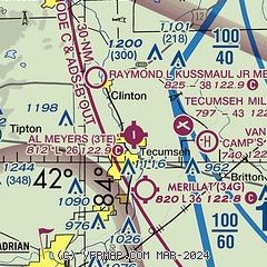
| Sectional chart |
|---|
|
| Airport distance calculator |
|---|
|
|
| Sunrise and sunset |
|---|
|
Times for 10-Feb-2026
| | Local
(UTC-5) | | Zulu
(UTC) |
|---|
| Morning civil twilight | | 07:10 | | 12:10 |
| Sunrise | | 07:39 | | 12:39 |
| Sunset | | 18:01 | | 23:01 |
| Evening civil twilight | | 18:30 | | 23:30 |
|
| Current date and time |
|---|
| Zulu (UTC) | 10-Feb-2026 16:41:33 |
|---|
| Local (UTC-5) | 10-Feb-2026 11:41:33 |
|---|
|
| METAR |
|---|
KADG
11nm SW | 101553Z AUTO 22004KT 8SM CLR 00/M04 A2980 RMK AO2 SLP100 T00001044
|
KARB
15nm NE | 734-668-7173
101553Z 20005KT 6SM HZ CLR 02/M05 A2977 RMK AO2 SLP089 T00171050
|
KDUH
22nm SE | 101615Z AUTO 27014G17KT 10SM CLR 07/M00 A2978 RMK AO2
|
KYIP
22nm NE | 101553Z 20009KT 10SM CLR 00/M05 A2977 RMK AO2 SLP088 T00001050
|
|
| TAF |
|---|
KYIP
22nm NE | 101120Z 1012/1112 20007KT P6SM SCT120 BKN200 WS020/23040KT FM101800 28010KT P6SM SCT035 BKN070 FM102200 30013G20KT P6SM OVC025 FM110300 30013KT P6SM BKN025 OVC040
|
KTOL
27nm S | 101140Z 1012/1112 18007KT P6SM BKN250 WS020/23045KT FM101700 25014G23KT P6SM SCT020 BKN100 FM102200 29012KT P6SM FEW020 FM110100 29014KT P6SM BKN025
|
|
| NOTAMs |
|---|
NOTAMs are issued by the DoD/FAA and will open in a separate window not controlled by AirNav.
|
|

