FAA INFORMATION EFFECTIVE 22 JANUARY 2026
Location
| FAA Identifier: | ADG |
| Lat/Long: | 41-52-03.4920N 084-04-38.3010W
41-52.058200N 084-04.638350W
41.8676367,-84.0773058
(estimated) |
| Elevation: | 802.2 ft. / 244.5 m (surveyed) |
| Variation: | 06W (2000) |
| From city: | 3 miles SW of ADRIAN, MI |
| Time zone: | UTC -5 (UTC -4 during Daylight Saving Time) |
| Zip code: | 49221 |
Airport Operations
| Airport use: | Open to the public |
| Activation date: | 12/1942 |
| Control tower: | no |
| ARTCC: | CLEVELAND CENTER |
| FSS: | LANSING FLIGHT SERVICE STATION |
| NOTAMs facility: | ADG (NOTAM-D service available) |
| Attendance: | MON-FRI 0800-1630, ALL SAT ON CALL
FOR SVC CALL AMGR AT 517-260-1745.
UNATNDD MAJOR HOLS. |
| Wind indicator: | lighted |
| Segmented circle: | yes |
| Lights: | ACTVT OR INCR INTST REIL RWY 05; PAPI RWY 05 & 23; HIRL RWY 05/23 - CTAF. HIRL RWY 05/23 PRESET LOW INTST. |
| Beacon: | white-green (lighted land airport)
Operates sunset to sunrise. |
| Landing fee: | no, LDG FEE FOR COML ACFT WAIVED WITH MNM FUEL PURCHASE. |
Airport Communications
| CTAF/UNICOM: | 122.8 |
| WX ASOS: | 118.825 (517-265-9089) |
| TOLEDO APPROACH: | 134.35 |
| TOLEDO DEPARTURE: | 134.35 |
| WX AWOS-3P at USE (16 nm S): | 127.375 (419-335-0775) |
Nearby radio navigation aids
| VOR radial/distance | | VOR name | | Freq | | Var |
|---|
| CRLr252/29.7 | | CARLETON VOR/DME | | 115.70 | | 03W |
| DXOr243/37.8 | | DETROIT VOR/DME | | 113.40 | | 06W |
| SVMr217/38.9 | | SALEM VORTAC | | 114.30 | | 03W |
| NDB name | | Hdg/Dist | | Freq | | Var | | ID |
|---|
| ADRIAN | | at field | | 278 | | 06W | | ADG | .- -.. --. |
Airport Services
| Fuel available: | 100LL JET-A+
100LL:100LL AVBL H24 SELF SVC VIA CREDIT CARD. |
| Parking: | hangars and tiedowns |
| Airframe service: | MAJOR |
| Powerplant service: | MAJOR |
Runway Information
Runway 5/23
| Dimensions: | 5001 x 100 ft. / 1524 x 30 m |
| Surface: | asphalt, in good condition |
| Weight bearing capacity: | |
| Runway edge lights: | high intensity |
| RUNWAY 5 | | RUNWAY 23 |
| Latitude: | 41-51.696633N | | 41-52.255547N |
| Longitude: | 084-05.083492W | | 084-04.274738W |
| Elevation: | 793.9 ft. | | 798.0 ft. |
| Traffic pattern: | left | | left |
| Runway heading: | 053 magnetic, 047 true | | 233 magnetic, 227 true |
| Markings: | nonprecision, in good condition | | nonprecision, in good condition |
| Visual slope indicator: | 4-light PAPI on left (3.00 degrees glide path) | | 4-light PAPI on left (3.00 degrees glide path) |
| Runway end identifier lights: | yes | | |
| Touchdown point: | yes, no lights | | yes, no lights |
| Obstructions: | 49 ft. tree, 1125 ft. from runway, 535 ft. right of centerline, 18:1 slope to clear | | 49 ft. tree, 923 ft. from runway, 593 ft. left of centerline, 14:1 slope to clear |
Runway 11/29
| Dimensions: | 1779 x 150 ft. / 542 x 46 m |
| Surface: | turf, in good condition |
| Runway edge markings: | YELLOW CONES. |
| Operational restrictions: | CLSD DEC-APR & WHEN SNOW COVD EXC FOR SKI EQUIPPED ACFT. NO SNOW REMOVAL. |
| RUNWAY 11 | | RUNWAY 29 |
| Latitude: | 41-52.332860N | | 41-52.245030N |
| Longitude: | 084-04.710655W | | 084-04.336722W |
| Elevation: | 802.2 ft. | | 797.0 ft. |
| Traffic pattern: | left | | left |
| Runway heading: | 113 magnetic, 107 true | | 293 magnetic, 287 true |
| Runway end identifier lights: | no | | no |
| Touchdown point: | yes, no lights | | yes, no lights |
| Obstructions: | 103 ft. tree, 2053 ft. from runway, 145 ft. left of centerline, 19:1 slope to clear | | none |
Airport Ownership and Management from official FAA records
| Ownership: | Publicly-owned |
| Owner: | LENAWEE COUNTY
301 N MAIN ST
ADRIAN, MI 49221-2714
Phone 517-265-2827 |
| Manager: | THOMAS KENDZIORA III
2651 W CADMUS RD
ADRIAN, MI 49221-8709
Phone 517-265-8993 |
Additional Remarks
| - | SNOW REMOVAL RWY 05/23 & TWYS ONLY. |
| - | TAXI ON HARD SFCS ONLY DURG SPRING THAW & WET CONDTIONS. |
| - | EXTSV GLDR OPS APR-OCT. |
| - | CTC CG OPS ON 156.8/381.8/2182.0/2687.0/5696.0. |
| - | FOR CD CTC TOLEDO APCH AT 419-865-1495. |
Instrument Procedures
NOTE: All procedures below are presented as PDF files. If you need a reader for these files, you should download the free Adobe Reader.NOT FOR NAVIGATION. Please procure official charts for flight.
FAA instrument procedures published for use from 22 January 2026 at 0901Z to 19 February 2026 at 0900z.
IAPs - Instrument Approach Procedures |
|---|
| RNAV (GPS) RWY 05 | |
download (220KB) |
| RNAV (GPS) RWY 23 | |
download (208KB) |
| NOTE: Special Alternate Minimums apply | |
download (20KB) |
| NOTE: Special Take-Off Minimums/Departure Procedures apply | |
download (122KB) |
Other nearby airports with instrument procedures:
KUSE - Fulton County Airport (16 nm S)
KDUH - Toledo Suburban Airport (20 nm SE)
KTOL - Eugene F Kranz Toledo Express Airport (21 nm SE)
KJYM - Hillsdale Municipal Airport (23 nm W)
KARB - Ann Arbor Municipal Airport (26 nm NE)
|
|

Road maps at:
MapQuest
Bing
Google
| Aerial photo |
|---|
WARNING: Photo may not be current or correct
 Photo courtesy of AirNav, LLC
Photo taken 21-Jul-2010
Photo courtesy of AirNav, LLC
Photo taken 21-Jul-2010
Do you have a better or more recent aerial photo of Lenawee County Airport that you would like to share? If so, please send us your photo.
|
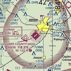
| Sectional chart |
|---|
|
| Airport distance calculator |
|---|
|
|
| Sunrise and sunset |
|---|
|
Times for 13-Feb-2026
| | Local
(UTC-5) | | Zulu
(UTC) |
|---|
| Morning civil twilight | | 07:07 | | 12:07 |
| Sunrise | | 07:36 | | 12:36 |
| Sunset | | 18:05 | | 23:05 |
| Evening civil twilight | | 18:34 | | 23:34 |
|
| Current date and time |
|---|
| Zulu (UTC) | 13-Feb-2026 20:19:52 |
|---|
| Local (UTC-5) | 13-Feb-2026 15:19:52 |
|---|
|
| METAR |
|---|
| KADG | 131953Z AUTO 22008KT 10SM CLR 02/M04 A3014 RMK AO2 SLP218 T00221044
|
KUSE
16nm S | 131955Z AUTO 19009KT 10SM CLR 04/M03 A3013 RMK AO2
|
|
| TAF |
|---|
KTOL
21nm SE | 131720Z 1318/1418 23005KT P6SM SCT250 FM140900 25004KT 4SM BR SKC FM141400 25003KT P6SM SKC
|
|
| NOTAMs |
|---|
NOTAMs are issued by the DoD/FAA and will open in a separate window not controlled by AirNav.
|
|

