FAA INFORMATION EFFECTIVE 09 JULY 2026
Location
| FAA Identifier: | 3U3 |
| Lat/Long: | 46-09-12.2922N 112-52-03.8444W
46-09.204870N 112-52.064073W
46.1534145,-112.8677346
(estimated) |
| Elevation: | 5034.2 ft. / 1534.4 m (surveyed) |
| Variation: | 14E (2010) |
| From city: | 3 miles NE of ANACONDA, MT |
| Time zone: | UTC -6 (UTC -7 during Standard Time) |
| Zip code: | 59711 |
Airport Operations
| Airport use: | Open to the public |
| Activation date: | 05/1963 |
| Control tower: | no |
| ARTCC: | SALT LAKE CITY CENTER |
| FSS: | GREAT FALLS FLIGHT SERVICE STATION |
| NOTAMs facility: | GTF (NOTAM-D service available) |
| Attendance: | UNATNDD
ARPT UNATNDD. CONDS UNMONITORED 1700 - 0800. |
| Wind indicator: | lighted |
| Segmented circle: | yes |
| Lights: | ACTVT PAPI RWY 04, 17, 22, & 35; MIRL RWY 04/22 & 17/35 - CTAF. |
| Beacon: | white-green (lighted land airport)
ROTG BCN LCTD MIDWAY OF RWY 04/22 & OFFSET 700 FT SE OF CNTRLN. Operates sunset to sunrise. |
Airport Communications
| CTAF/UNICOM: | 122.8 |
| WX AWOS-3PT: | 124.175 (406-563-8275) |
| WX AWOS-AV at 38S (15 nm N): | 120.025 (406-846-1177) |
| WX ASOS at BTM (19 nm SE): | 135.175 (406-494-1870) |
- APCH/DEP CTL SVC PRVDD BY SALT LAKE ARTCC (ZLC) ON FREQS 132.4/338.3 (BUTTE RCAG).
Nearby radio navigation aids
| VOR radial/distance | | VOR name | | Freq | | Var |
|---|
| CPNr310/8.8 | | COPPERTOWN VOR/DME | | 116.05 | | 16E |
| HIAr283/33.9 | | WHITEHALL VOR/DME | | 113.70 | | 18E |
Airport Services
| Fuel available: | 100LL |
| Parking: | hangars and tiedowns |
| Airframe service: | NONE |
| Powerplant service: | NONE |
| Bottled oxygen: | NONE |
| Bulk oxygen: | NONE |
Runway Information
Runway 17/35
| Dimensions: | 6010 x 75 ft. / 1832 x 23 m |
| Surface: | asphalt, in excellent condition |
| Weight bearing capacity: | | Single wheel: | 39.0 | | Double wheel: | 55.0 |
|
| Runway edge lights: | medium intensity |
| RUNWAY 17 | | RUNWAY 35 |
| Latitude: | 46-09.836047N | | 46-08.847167N |
| Longitude: | 112-52.268195W | | 112-52.267462W |
| Elevation: | 4998.2 ft. | | 5032.6 ft. |
| Traffic pattern: | left | | right |
| Runway heading: | 166 magnetic, 180 true | | 346 magnetic, 360 true |
| Markings: | nonprecision, in good condition | | nonprecision, in good condition |
| Visual slope indicator: | 2-light PAPI on left (3.00 degrees glide path) | | 2-light PAPI on left (3.00 degrees glide path) |
| Touchdown point: | yes, no lights | | yes, no lights |
Runway 4/22
| Dimensions: | 4074 x 60 ft. / 1242 x 18 m |
| Surface: | asphalt, in excellent condition |
| Weight bearing capacity: | | Single wheel: | 18.0 | | Double wheel: | 25.0 |
|
| Runway edge lights: | medium intensity |
| RUNWAY 4 | | RUNWAY 22 |
| Latitude: | 46-08.821640N | | 46-09.184022N |
| Longitude: | 112-52.168988W | | 112-51.358000W |
| Elevation: | 5029.8 ft. | | 4989.0 ft. |
| Traffic pattern: | left | | left |
| Runway heading: | 043 magnetic, 057 true | | 223 magnetic, 237 true |
| Markings: | basic, in good condition | | basic, in good condition |
| Visual slope indicator: | 2-light PAPI on left (3.25 degrees glide path) | | 2-light PAPI on left (3.00 degrees glide path) |
| Touchdown point: | yes, no lights | | yes, no lights |
Airport Ownership and Management from official FAA records
| Ownership: | Publicly-owned |
| Owner: | ANACONDA DEERLODGE COUNTY
800 S. MAIN ST
ANACONDA, MT 59711
Phone 406-563-4000 |
| Manager: | MONTE BELGARDE
800 S MAIN ST
ANACONDA, MT 59711
Phone 406-490-3627 |
Additional Remarks
| A39-17/35 | PCR VALUE: 150/F/D/X/T |
| - | UNLIGHTED HAZARDOUS STACK; 585 FT AGL LCTD 3.2 NM SW OF ARPT. |
| - | COLD TEMPERATURE AIRPORT. ALTITUDE CORRECTION REQUIRED AT OR BELOW -25C. |
| - | FOR CD CTC SALT LAKE ARTCC AT 801-320-2568. |
| - | AWOS AVBL 124.175 MHZ AND 406-563-8275 |
| - | SEE HTTPS://WEATHERCAMS.FAA.GOV OR CALL AMGR FOR CURRENT RWY CONDS. |
Instrument Procedures
NOTE: All procedures below are presented as PDF files. If you need a reader for these files, you should download the free Adobe Reader.NOT FOR NAVIGATION. Please procure official charts for flight.
FAA instrument procedures published for use from 09 July 2026 at 0901Z to 06 August 2026 at 0900Z.
IAPs - Instrument Approach Procedures |
|---|
| RNAV (GPS)-B | |
download (326KB) |
| VOR-A | |
download (359KB) |
| NOTE: Special Take-Off Minimums/Departure Procedures apply | |
download (530KB) |
Other nearby airports with instrument procedures:
38S - Deer Lodge-City-County Airport (15 nm N)
KBTM - Bert Mooney Airport (19 nm SE)
KRVF - Ruby Valley Field Airport (44 nm SE)
KHLN - Helena Regional Airport (46 nm NE)
S69 - Lincoln Airport (49 nm N)
|
|

Road maps at:
MapQuest
Bing
Google
| Aerial photo |
|---|
WARNING: Photo may not be current or correct

Do you have a better or more recent aerial photo of Bowman Field Airport that you would like to share? If so, please send us your photo.
|
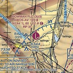
| Sectional chart |
|---|
|
| Airport distance calculator |
|---|
|
|
| Sunrise and sunset |
|---|
|
Times for 25-Jul-2026
| | Local
(UTC-6) | | Zulu
(UTC) |
|---|
| Morning civil twilight | | 05:31 | | 11:31 |
| Sunrise | | 06:06 | | 12:06 |
| Sunset | | 21:10 | | 03:10 |
| Evening civil twilight | | 21:45 | | 03:45 |
|
| Current date and time |
|---|
| Zulu (UTC) | 25-Jul-2026 09:59:40 |
|---|
| Local (UTC-6) | 25-Jul-2026 03:59:40 |
|---|
|
| METAR |
|---|
| K3U3 | 250955Z AUTO 22009KT 10SM CLR 16/09 A3004 RMK AO2 T01600089 $
|
KBTM
19nm SE | 250953Z AUTO 15003KT 10SM CLR 14/10 A3010 RMK AO2 SLP123 T01440100
|
|
| TAF |
|---|
KBTM
19nm SE | 250530Z 2506/2606 16008KT P6SM SKC FM252000 23012G20KT P6SM FEW090 PROB30 2521/2524 22015G30KT 6SM -TSRA BKN090CB FM260300 26008KT P6SM SCT120
|
|
| NOTAMs |
|---|
NOTAMs are issued by the DoD/FAA and will open in a separate window not controlled by AirNav.
|
|


