FAA INFORMATION EFFECTIVE 09 JULY 2026
Location
| FAA Identifier: | 3W7 |
| Lat/Long: | 47-55-19.4000N 119-04-58.8000W
47-55.323333N 119-04.980000W
47.9220556,-119.0830000
(estimated) |
| Elevation: | 1593.1 ft. / 485.6 m (surveyed) |
| Variation: | 15E (2020) |
| From city: | 2 miles SW of ELECTRIC CITY, WA |
| Time zone: | UTC -7 (UTC -8 during Standard Time) |
| Zip code: | 99123 |
Airport Operations
| Airport use: | Open to the public |
| Activation date: | 10/1972 |
| Control tower: | no |
| ARTCC: | SEATTLE CENTER |
| FSS: | SEATTLE FLIGHT SERVICE STATION |
| NOTAMs facility: | SEA (NOTAM-D service available) |
| Attendance: | UNATNDD |
| Wind indicator: | lighted |
| Segmented circle: | yes |
| Lights: | ACTVT REIL RWY 22; PAPI RWY 22; MIRL RWY 04/22 - CTAF. |
| Beacon: | white-green (lighted land airport)
Operates sunset to sunrise. |
Airport Communications
| CTAF: | 122.9 |
| WX AWOS-3PT: | 128.325 (509-631-8955) |
| WX AWOS-2 at 2S8 (17 nm SE): | 124.175 (509-647-0337) |
- APCH/DEP SVC PRVDD BY SEATTLE ARTCC (ZSE) ON FREQS 126.1/291.6 (MARLIN RCAG).
Nearby radio navigation aids
| VOR radial/distance | | VOR name | | Freq | | Var |
|---|
| EPHr002/35.4 | | EPHRATA VORTAC | | 112.60 | | 21E |
Airport Services
| Parking: | tiedowns |
| Airframe service: | NONE |
| Powerplant service: | NONE |
| Bottled oxygen: | NONE |
| Bulk oxygen: | NONE |
Runway Information
Runway 4/22
| Dimensions: | 4203 x 75 ft. / 1281 x 23 m |
| Surface: | asphalt, in good condition |
| Weight bearing capacity: | |
| Runway edge lights: | medium intensity |
| RUNWAY 4 | | RUNWAY 22 |
| Latitude: | 47-55.106768N | | 47-55.538815N |
| Longitude: | 119-05.381922W | | 119-04.579373W |
| Elevation: | 1588.7 ft. | | 1589.0 ft. |
| Traffic pattern: | left | | right |
| Runway heading: | 036 magnetic, 051 true | | 216 magnetic, 231 true |
| Markings: | basic, in good condition | | nonprecision, in good condition |
| Visual slope indicator: | | | 2-light PAPI on left (4.20 degrees glide path) |
| Runway end identifier lights: | | | yes |
| Touchdown point: | yes, no lights | | yes, no lights |
| Obstructions: | 490 ft. hill, 9000 ft. from runway, 17:1 slope to clear
15 FT TREE 61 FT FM THR, 73 FT LEFT & DITCH 27 FT FM THR, 91 FT RIGHT. | | 30 ft. gnd, 1195 ft. from runway, 33:1 slope to clear
BRUSH 79 FT RIGHT; SLP & BRUSH 100 FT FM THR, 99 FT LEFT. |
Airport Ownership and Management from official FAA records
| Ownership: | Publicly-owned |
| Owner: | GRANT CO PORT DIST NR 7
P.O. BOX 616
GRAND COULEE, WA 99133
Phone 509-631-4797 |
| Manager: | ROBERT BABLER
P.O. BOX 182
GRAND COULEE, WA 99133
Phone 509-631-4797 |
Additional Remarks
| - | GEESE & WILDLIFE INVOF RWY. |
| - | FOR CD CTC SEATTLE ARTCC AT 253-351-3694. |
Instrument Procedures
NOTE: All procedures below are presented as PDF files. If you need a reader for these files, you should download the free Adobe Reader.NOT FOR NAVIGATION. Please procure official charts for flight.
FAA instrument procedures published for use from 09 July 2026 at 0901Z to 06 August 2026 at 0900Z.
IAPs - Instrument Approach Procedures |
|---|
| RNAV (GPS) Y RWY 22 | |
download (221KB) |
| RNAV (GPS) Z RWY 22 | |
download (243KB) |
| NOTE: Special Alternate Minimums apply | |
download (213KB) |
|
|---|
| SINGG ONE (OBSTACLE) (RNAV) | |
download (200KB) |
| NOTE: Special Take-Off Minimums/Departure Procedures apply | |
download (558KB) |
Other nearby airports with instrument procedures:
2S8 - Wilbur Airport (17 nm SE)
KOMK - Omak Airport (37 nm NW)
KEPH - Ephrata Municipal Airport (41 nm SW)
KMWH - Grant County International Airport (44 nm S)
KEAT - Pangborn Memorial Airport (55 nm SW)
|
|

Road maps at:
MapQuest
Bing
Google
| Aerial photo |
|---|
WARNING: Photo may not be current or correct
 Photo taken 23-Jun-2020
looking east-northeast at 1800 MSL.
Photo taken 23-Jun-2020
looking east-northeast at 1800 MSL.
Do you have a better or more recent aerial photo of Grand Coulee Dam Airport that you would like to share? If so, please send us your photo.
|
| Sectional chart |
|---|
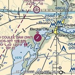
|
| Airport distance calculator |
|---|
|
|
| Sunrise and sunset |
|---|
|
Times for 18-Jul-2026
| | Local
(UTC-7) | | Zulu
(UTC) |
|---|
| Morning civil twilight | | 04:38 | | 11:38 |
| Sunrise | | 05:17 | | 12:17 |
| Sunset | | 20:48 | | 03:48 |
| Evening civil twilight | | 21:27 | | 04:27 |
|
| Current date and time |
|---|
| Zulu (UTC) | 18-Jul-2026 08:13:51 |
|---|
| Local (UTC-7) | 18-Jul-2026 01:13:51 |
|---|
|
| METAR |
|---|
KOMK
37nm NW | 180753Z AUTO 16004KT 10SM CLR 24/04 A2987 RMK AO2 SLP104 T02390044 403500194
|
KEPH
41nm SW | 180753Z AUTO 00000KT 10SM CLR 19/07 A2989 RMK AO2 SLP112 T01890067 403280150
|
KMWH
44nm S | 180752Z AUTO 22009KT 10SM CLR 20/11 A2990 RMK AO2 SLP116 T02000106 403280150
|
|
| TAF |
|---|
KMWH
44nm S | 180528Z 1806/1906 22006KT P6SM SKC FM182000 22011G20KT P6SM SKC FM190100 26012G21KT P6SM SKC FM190300 30012G20KT P6SM FEW140
|
|
| NOTAMs |
|---|
NOTAMs are issued by the DoD/FAA and will open in a separate window not controlled by AirNav.
|
|

