FAA INFORMATION EFFECTIVE 09 JULY 2026
Location
| FAA Identifier: | EAT |
| Lat/Long: | 47-23-55.7000N 120-12-24.6000W
47-23.928333N 120-12.410000W
47.3988056,-120.2068333
(estimated) |
| Elevation: | 1248.9 ft. / 380.7 m (surveyed) |
| Variation: | 15E (2020) |
| From city: | 4 miles E of WENATCHEE, WA |
| Time zone: | UTC -7 (UTC -8 during Standard Time) |
| Zip code: | 98802 |
Airport Operations
| Airport use: | Open to the public |
| Activation date: | 08/1942 |
| Control tower: | no |
| ARTCC: | SEATTLE CENTER |
| FSS: | SEATTLE FLIGHT SERVICE STATION |
| NOTAMs facility: | EAT (NOTAM-D service available) |
| Attendance: | 0800-1800 |
| Wind indicator: | lighted |
| Segmented circle: | yes |
| Lights: | ACTVT MALSR RWY 12; REIL 30; HIRL RWY 12/30 - CTAF. PAPI RWY 12 & 30 OPR CONSLY. |
| Beacon: | white-green (lighted land airport)
Operates sunset to sunrise. |
| Landing fee: | yes |
| Fire and rescue: | ARFF index A |
| Airline operations: | 24 HR PPR FOR UNSKED ACR OPNS WITH MORE THAN 30 PAX SEATS CALL AP OPS (509) 860-1852. |
Airport Communications
| CTAF/UNICOM: | 123.0 |
| WX ASOS: | 119.925 (509-886-4226) |
- APCH/DEP CTL SVC PRVDD BY SEATTLE ARTCC (ZSE) ON FREQS 126.1 (WENATCHEE RCAG).
Nearby radio navigation aids
| VOR radial/distance | | VOR name | | Freq | | Var |
|---|
| EAT at field | | WENATCHEE VOR/DME | | 114.35 | | 15E |
| ELNr004/24.7 | | ELLENSBURG VOR/DME | | 117.90 | | 21E |
| EPHr251/31.8 | | EPHRATA VORTAC | | 112.60 | | 21E |
| MWHr269/37.9 | | MOSES LAKE VOR/DME | | 115.00 | | 18E |
Airport Services
| Fuel available: | 100LL JET-A |
| Parking: | tiedowns |
| Airframe service: | MAJOR |
| Powerplant service: | MAJOR |
| Bottled oxygen: | NONE |
| Bulk oxygen: | HIGH/LOW |
Runway Information
Runway 12/30
| Dimensions: | 7000 x 150 ft. / 2134 x 46 m |
| Surface: | asphalt, in good condition |
| Weight bearing capacity: | | Single wheel: | 116.0 | | Double wheel: | 192.0 |
|
| Runway edge lights: | high intensity |
| RUNWAY 12 | | RUNWAY 30 |
| Latitude: | 47-24.344775N | | 47-23.530270N |
| Longitude: | 120-13.036298W | | 120-11.837740W |
| Elevation: | 1216.8 ft. | | 1231.0 ft. |
| Traffic pattern: | right | | left |
| Runway heading: | 120 magnetic, 135 true | | 300 magnetic, 315 true |
| Declared distances: | TORA:7000 TODA:7000 ASDA:7000 LDA:7000 | | TORA:7000 TODA:7000 ASDA:7000 LDA:7000 |
| Markings: | precision, in good condition | | nonprecision, in good condition |
| Visual slope indicator: | 4-light PAPI on left (3.60 degrees glide path) | | 4-light PAPI on left (3.60 degrees glide path)
UNUSBL BYD 2.6 NM DUE TO TRRN. |
| Approach lights: | MALSR: 1,400 foot medium intensity approach lighting system with runway alignment indicator lights | | |
| Runway end identifier lights: | no | | yes |
| Touchdown point: | yes, no lights | | yes, no lights |
| Instrument approach: | ILS/DME | | |
| Obstructions: | 18 ft. road, 500 ft. from runway, 280 ft. left of centerline, 16:1 slope to clear | | none |
Airport Ownership and Management from official FAA records
| Ownership: | Publicly-owned |
| Owner: | PORTS CHELAN&DOUGLAS CNTY
3764 AIRPORT WAY
EAST WENATCHEE, WA 98802
Phone 509-884-4700 |
| Manager: | TRENT MOYERS
ONE CAMPBELL PARKWAY
EAST WENATCHEE, WA 98802
Phone 509-884-4700 |
Additional Remarks
| A39-12/30 | PCR VALUE: 450/F/A/X/T |
| - | GLIDER ACTIVITY FROM MAR-NOV. |
| - | COLD TEMPERATURE AIRPORT. ALTITUDE CORRECTION REQUIRED AT OR BELOW -6C. |
| - | UAS ACTVTY 1.56 NM E OF THE EAT VOR, 400 FT & BLW DURG DALGT HRS. |
| - | FOR CD IF UNA TO CTC ON FSS FREQ, CTC SEATTLE ARTCC AT 253-351-3694. |
Instrument Procedures
NOTE: All procedures below are presented as PDF files. If you need a reader for these files, you should download the free Adobe Reader.NOT FOR NAVIGATION. Please procure official charts for flight.
FAA instrument procedures published for use from 09 July 2026 at 0901Z to 06 August 2026 at 0900Z.
IAPs - Instrument Approach Procedures |
|---|
| ILS Y RWY 12 | |
download (501KB) |
| ILS Z RWY 12 | |
download (521KB) |
| RNAV (RNP) RWY 12 | |
download (443KB) |
| RNAV (RNP) Z RWY 30 | |
download (412KB) |
| VOR-A | |
download (405KB) |
| VOR-B | |
download (590KB) |
| NOTE: Special Alternate Minimums apply | |
download (179KB) |
Departure Procedures |
|---|
| OFARO TWO (RNAV) | |
download (171KB) |
| ZARLO TWO (RNAV) | |
download (182KB) |
|
|---|
| WENATCHEE TWO (OBSTACLE) | |
2 pages:
[1] [2] (470KB) |
| NOTE: Special Take-Off Minimums/Departure Procedures apply | |
download (530KB) |
Other nearby airports with instrument procedures:
KELN - Bowers Field Airport (25 nm SW)
KEPH - Ephrata Municipal Airport (29 nm E)
KMWH - Grant County International Airport (38 nm E)
KYKM - Yakima Air Terminal/McAllister Field (52 nm S)
3W7 - Grand Coulee Dam Airport (55 nm NE)
|
|

Road maps at:
MapQuest
Bing
Google
| Aerial photo |
|---|
WARNING: Photo may not be current or correct

Do you have a better or more recent aerial photo of Pangborn Memorial Airport that you would like to share? If so, please send us your photo.
|
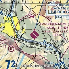
| Sectional chart |
|---|
|
| Airport distance calculator |
|---|
|
|
| Sunrise and sunset |
|---|
|
Times for 03-Aug-2026
| | Local
(UTC-7) | | Zulu
(UTC) |
|---|
| Morning civil twilight | | 05:07 | | 12:07 |
| Sunrise | | 05:43 | | 12:43 |
| Sunset | | 20:31 | | 03:31 |
| Evening civil twilight | | 21:07 | | 04:07 |
|
| Current date and time |
|---|
| Zulu (UTC) | 03-Aug-2026 12:22:55 |
|---|
| Local (UTC-7) | 03-Aug-2026 05:22:55 |
|---|
|
| METAR |
|---|
| KEAT | 031155Z AUTO 33009KT 10SM OVC034 14/06 A3019 RMK AO2 SLP218 T01440056 10178 20139 51009
|
|
| TAF |
|---|
| KEAT | 031149Z 0312/0412 34011KT P6SM OVC040 FM031800 29006KT 4SM FU BKN040 BKN250 FM032100 VRB06KT 4SM FU BKN040 BKN250 FM040500 32005KT P6SM SKC
|
|
| NOTAMs |
|---|
NOTAMs are issued by the DoD/FAA and will open in a separate window not controlled by AirNav.
|
|


