FAA INFORMATION EFFECTIVE 23 JANUARY 2025
Location
| FAA Identifier: | YKM |
| Lat/Long: | 46-34-05.4020N 120-32-38.6250W
46-34.090033N 120-32.643750W
46.5681672,-120.5440625
(estimated) |
| Elevation: | 1098.8 ft. / 334.9 m (surveyed) |
| Variation: | 16E (2010) |
| From city: | 3 miles S of YAKIMA, WA |
| Time zone: | UTC -8 (UTC -7 during Daylight Saving Time) |
| Zip code: | 98903 |
Airport Operations
| Airport use: | Open to the public |
| Activation date: | 11/1937 |
| Control tower: | yes |
| ARTCC: | SEATTLE CENTER |
| FSS: | SEATTLE FLIGHT SERVICE STATION |
| NOTAMs facility: | YKM (NOTAM-D service available) |
| Attendance: | 0600 - 2000 |
| Wind indicator: | lighted |
| Segmented circle: | yes |
| Lights: | WHEN ATCT CLSD ACTVT HIRL RY 09/27; MALSR RY 27 - CTAF. |
| Beacon: | white-green (lighted land airport)
Operates sunset to sunrise. |
| Fire and rescue: | ARFF index A |
| Airline operations: | PPR FOR UNSKED ACR OPNS WITH MORE THAN 30 PSGR SEATS CALL AMGR 509-575-6149/6150. |
Airport Communications
| CTAF: | 133.25 |
| UNICOM: | 122.95 |
| ATIS: | 125.25 |
| WX ASOS: | PHONE 509-248-1502 |
| YAKIMA GROUND: | 121.9 [0600-2200] |
| YAKIMA TOWER: | 133.25 257.8 [0600-2200] |
| SPOKANE APPROACH: | 123.8 |
| SPOKANE DEPARTURE: | 123.8 |
| CLEARANCE DELIVERY: | 121.9 |
| EMERG: | 121.5 243.0 |
| IC: | 123.8 |
| WX ASOS at FCT (7 nm NE): | 118.15 |
- DURING HRS ATCT CLSD; ALL OPNS IN VICINITY OF AIRPORT RESTRICTED TO ACFT WITH VHF RADIO CAPABILITY; UNLESS EMERGENCY EXISTS NECESSITATING UHF EQUIPPED ACFT TO LAND AT YAKIMA.
- APCH/DEP CTL SVC PROVDD BY SEATTLE ARTCC (ZSE) ON 132.6/269.35 (YAKIMA RCAG), WHEN GEG APCH CLSD.
Nearby radio navigation aids
| VOR radial/distance | | VOR name | | Freq | | Var |
|---|
| YKMr247/4.1 | | YAKIMA VORTAC | | 116.00 | | 21E |
| ELNr166/27.6 | | ELLENSBURG VOR/DME | | 117.90 | | 21E |
Airport Services
| Fuel available: | 100LL JET-A |
| Parking: | tiedowns |
| Airframe service: | MAJOR |
| Powerplant service: | MAJOR |
| Bottled oxygen: | HIGH |
| Bulk oxygen: | HIGH |
Runway Information
Runway 9/27
| Dimensions: | 7604 x 150 ft. / 2318 x 46 m |
| Surface: | asphalt/grooved, in excellent condition |
| Weight bearing capacity: | | Single wheel: | 95.0 | | Double wheel: | 160.0 | | Double tandem: | 220.0 | | Dual double tandem: | 550.0 |
|
| Runway edge lights: | high intensity |
| RUNWAY 9 | | RUNWAY 27 |
| Latitude: | 46-34.353108N | | 46-33.925495N |
| Longitude: | 120-33.572320W | | 120-31.867873W |
| Elevation: | 1098.8 ft. | | 1048.7 ft. |
| Traffic pattern: | left | | left |
| Runway heading: | 094 magnetic, 110 true | | 274 magnetic, 290 true |
| Declared distances: | TORA:7604 TODA:7604 ASDA:7604 LDA:7604 | | TORA:7604 TODA:7604 ASDA:7604 LDA:7604 |
| Markings: | nonprecision, in good condition | | precision, in good condition |
| Visual slope indicator: | 4-box VASI on left (3.00 degrees glide path) | | 4-light PAPI on left (3.00 degrees glide path) |
| RVR equipment: | rollout | | touchdown |
| Approach lights: | | | MALSR: 1,400 foot medium intensity approach lighting system with runway alignment indicator lights |
| Runway end identifier lights: | yes | | |
| Touchdown point: | yes, no lights | | yes, no lights |
| Instrument approach: | | | ILS/DME |
Runway 4/22
| Dimensions: | 3835 x 150 ft. / 1169 x 46 m |
| Surface: | asphalt/porous friction courses, in poor condition
RY 04/22 SOME SPALLING AND RAVELING. |
| Weight bearing capacity: | | Single wheel: | 70.0 | | Double wheel: | 80.0 | | Double tandem: | 120.0 |
|
| Runway edge lights: | medium intensity |
| RUNWAY 4 | | RUNWAY 22 |
| Latitude: | 46-33.834022N | | 46-34.150463N |
| Longitude: | 120-32.888050W | | 120-32.096822W |
| Elevation: | 1076.3 ft. | | 1055.4 ft. |
| Traffic pattern: | left | | left |
| Runway heading: | 044 magnetic, 060 true | | 224 magnetic, 240 true |
| Declared distances: | TORA:3835 TODA:3835 ASDA:3835 LDA:3835 | | TORA:3835 TODA:3835 ASDA:3835 LDA:3835 |
| Markings: | basic, in good condition | | basic, in good condition |
| Visual slope indicator: | 4-light PAPI on left (3.00 degrees glide path) | | 4-light PAPI on left (3.00 degrees glide path) |
| Runway end identifier lights: | yes | | yes |
| Touchdown point: | yes, no lights | | yes, no lights |
Airport Ownership and Management from official FAA records
| Ownership: | Publicly-owned |
| Owner: | CITY OF YAKIMA
2300 WEST WASHINGTON AVE
YAKIMA, WA 98903
Phone (509) 575-6149 |
| Manager: | ROBERT HODGMAN
2406 WEST WASHINGTON AVE, SUITE B
YAKIMA, WA 98903
Phone 509-575-6149 |
Additional Remarks
| A39-09/27 | PCR VALUE: 814/F/C/X/T |
| A39-04/22 | PCR VALUE: 282/F/D/X/T |
| - | RWY 4/22 MIRL, REILS AND PAPIS OTS WHEN TWR CLOSED. |
| - | TWY B1 AND TWY B2 TWY LIGHTS OTS WHEN TWR CLOSED. |
| - | TWY B LIGHTS SOUTH OF RWY 9/27 OTS WHEN TWR CLOSED. |
| - | REFLECTORS ON TWY C ONLY. |
| - | MAIN TERMINAL RAMP RESTRICTED TO AIR CARRIER AIRCRAFT ONLY. RESTRICTED AREA OUTLINED WITH RED MARKINGS. |
| - | FOR CD IF UNA TO CTC ON FSS FREQ, CTC SEATTLE ARTCC AT 253-351-3694. |
| - | BE ALERT: BIRDS IN VICINTY OF YAKIMA RIVER 5 NM E OF APCH TO 27. |
| - | TWY B FM APCH END OF RY 22 TO TWY A RESTRICTED TO ACFT WITH WINGSPANS OF 79 FT OR LESS. |
| - | SURF CONDS UNMON 2400-0500. |
Instrument Procedures
NOTE: All procedures below are presented as PDF files. If you need a reader for these files, you should download the free Adobe Reader.NOT FOR NAVIGATION. Please procure official charts for flight.
FAA instrument procedures published for use from 23 January 2025 at 0901Z to 20 February 2025 at 0900z.
IAPs - Instrument Approach Procedures |
|---|
| ILS OR LOC RWY 27 | |
download (421KB) |
| RNAV (RNP) RWY 09 | |
download (407KB) |
| RNAV (RNP) Y RWY 27 | |
download (400KB) |
| RNAV (RNP) Z RWY 27 | |
download (411KB) |
| RNAV (GPS) X RWY 27 | |
download (379KB) |
| LOC/DME BC-B | |
download (505KB) |
| VOR/DME OR TACAN RWY 27 | |
download (374KB) |
| VOR-A | |
download (312KB) |
| NOTE: Special Alternate Minimums apply | |
download (210KB) |
Departure Procedures |
|---|
| GROMO FOUR | |
2 pages:
[1] [2] (394KB) |
| NACHES FOUR | |
2 pages:
[1] [2] (312KB) |
| WENAS SEVEN | |
2 pages:
[1] [2] (352KB) |
| YAKIMA SEVEN | |
download (146KB) |
|
|---|
| ZILLA THREE (OBSTACLE) | |
download (254KB) |
| NOTE: Special Take-Off Minimums/Departure Procedures apply | |
download (530KB) |
Other nearby airports with instrument procedures:
KELN - Bowers Field Airport (28 nm N)
KEAT - Pangborn Memorial Airport (52 nm N)
KRLD - Richland Airport (54 nm E)
KEPH - Ephrata Municipal Airport (61 nm NE)
KPSC - Tri-Cities Airport (62 nm E)
|
|

Road maps at:
MapQuest
Bing
Google
| Aerial photo |
|---|
WARNING: Photo may not be current or correct
 Photo by Blaine E. Fisher
Photo taken 16-Sep-2007
Photo by Blaine E. Fisher
Photo taken 16-Sep-2007
Do you have a better or more recent aerial photo of Yakima Air Terminal/McAllister Field that you would like to share? If so, please send us your photo.
|
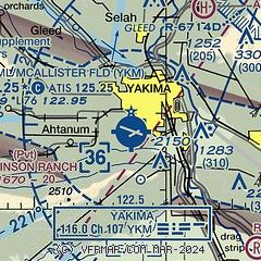
| Sectional chart |
|---|
|
CAUTION: Diagram may not be current
 Download PDF
of official airport diagram from the FAA
| Airport distance calculator |
|---|
|
|
| Sunrise and sunset |
|---|
|
Times for 08-Feb-2025
| | Local
(UTC-8) | | Zulu
(UTC) |
|---|
| Morning civil twilight | | 06:46 | | 14:46 |
| Sunrise | | 07:17 | | 15:17 |
| Sunset | | 17:15 | | 01:15 |
| Evening civil twilight | | 17:47 | | 01:47 |
|
| Current date and time |
|---|
| Zulu (UTC) | 09-Feb-2025 01:02:09 |
|---|
| Local (UTC-8) | 08-Feb-2025 17:02:09 |
|---|
|
| METAR |
|---|
| KYKM | 090053Z 00000KT 6SM -SN BKN025 BKN055 03/M03 A3029 RMK AO2 SLP270 P0000 T00281028
|
|
| TAF |
|---|
| KYKM | 081727Z 0818/0918 VRB03KT P6SM BKN040 OVC080 FM090100 VRB03KT P6SM OVC035 FM091200 28004KT P6SM OVC050 FM091500 28004KT P6SM OVC025
|
|
| NOTAMs |
|---|
NOTAMs are issued by the DoD/FAA and will open in a separate window not controlled by AirNav.
|
|


