FAA INFORMATION EFFECTIVE 11 JUNE 2026
Location
| FAA Identifier: | 5F4 |
| Lat/Long: | 32-47-18.6000N 093-00-13.1190W
32-47.310000N 093-00.218650W
32.7885000,-93.0036442
(estimated) |
| Elevation: | 244.1 ft. / 74.4 m (surveyed) |
| Variation: | 02E (2005) |
| From city: | 3 miles E of HOMER, LA |
| Time zone: | UTC -5 (UTC -6 during Standard Time) |
| Zip code: | 71040 |
Airport Operations
| Airport use: | Open to the public |
| Activation date: | 01/1970 |
| Control tower: | no |
| ARTCC: | FORT WORTH CENTER |
| FSS: | DE RIDDER FLIGHT SERVICE STATION |
| NOTAMs facility: | DRI (NOTAM-D service available) |
| Attendance: | UNATNDD |
| Wind indicator: | lighted |
| Segmented circle: | yes |
| Lights: | REIL RWY 12/30; MIRL RWY 12/30 PRESET LOW INTST DUSK-DAWN; TO INCR INTST ACTVT - CTAF. |
| Beacon: | white-green (lighted land airport)
Operates sunset to sunrise. |
Airport Communications
| CTAF: | 122.9 |
| WX AWOS-3PT at MNE (17 nm SW): | 119.325 (318-371-7874) |
Nearby radio navigation aids
| VOR radial/distance | | VOR name | | Freq | | Var |
|---|
| ELDr198/31.0 | | EL DORADO VOR/DME | | 115.50 | | 07E |
| EMGr045/37.9 | | ELM GROVE VORTAC | | 116.65 | | 07E |
Airport Services
Runway Information
Runway 12/30
| Dimensions: | 3200 x 60 ft. / 975 x 18 m |
| Surface: | asphalt, in good condition
EXCESSIVE RWY EDGE LIPS EXIST AFTER OVERLAY PROJECT. PILOTS ARE CAUTIONED TO STAY IN THE CTR OF THE RWY & TWY. |
| Weight bearing capacity: | |
| Runway edge lights: | medium intensity |
| RUNWAY 12 | | RUNWAY 30 |
| Latitude: | 32-47.451785N | | 32-47.168210N |
| Longitude: | 093-00.482088W | | 092-59.955230W |
| Elevation: | 244.0 ft. | | 228.2 ft. |
| Traffic pattern: | left | | left |
| Runway heading: | 120 magnetic, 122 true | | 300 magnetic, 302 true |
| Markings: | basic, in good condition | | basic, in good condition |
| Runway end identifier lights: | yes | | yes |
| Touchdown point: | yes, no lights | | yes, no lights |
| Obstructions: | 63 ft. trees, 356 ft. from runway, 183 ft. left of centerline, 2:1 slope to clear | | 66 ft. trees, 461 ft. from runway, 283 ft. right of centerline, 3:1 slope to clear |
Airport Ownership and Management from official FAA records
| Ownership: | Publicly-owned |
| Owner: | CITY OF HOMER
400 EAST MAIN
HOMER, LA 71040
Phone 318-927-3555 |
| Manager: | JERRY WHITTON
550 AIRPORT LOOP, FIRE STATION
HOMER, LA 71040
Phone 318-225-0911 |
Additional Remarks
| - | FOR CD CTC FORT WORTH ARTCC AT 817-858-7584. |
| - | CTC APRT MGR FOR DSGND RAMP SPACE FOR PUB USE. |
Instrument Procedures
There are no published instrument procedures at 5F4.
Some nearby airports with instrument procedures:
KMNE - Minden Airport (17 nm SW)
KSPH - Springhill Airport (24 nm NW)
KRSN - Ruston Regional Airport (27 nm SE)
KELD - South Arkansas Regional Airport at Goodwin Field (28 nm N)
KAGO - Ralph C Weiser Field Airport (28 nm N)
|
|

Road maps at:
MapQuest
Bing
Google
| Aerial photo |
|---|
WARNING: Photo may not be current or correct
 Photo by Mark Burns
Photo taken 01-May-2006
Photo by Mark Burns
Photo taken 01-May-2006
Do you have a better or more recent aerial photo of Homer Municipal Airport that you would like to share? If so, please send us your photo.
|
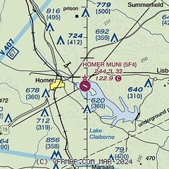
| Sectional chart |
|---|
|
| Airport distance calculator |
|---|
|
|
| Sunrise and sunset |
|---|
|
Times for 18-Jun-2026
| | Local
(UTC-5) | | Zulu
(UTC) |
|---|
| Morning civil twilight | | 05:36 | | 10:36 |
| Sunrise | | 06:05 | | 11:05 |
| Sunset | | 20:21 | | 01:21 |
| Evening civil twilight | | 20:50 | | 01:50 |
|
| Current date and time |
|---|
| Zulu (UTC) | 18-Jun-2026 06:59:23 |
|---|
| Local (UTC-5) | 18-Jun-2026 01:59:23 |
|---|
|
| METAR |
|---|
KMNE
17nm SW | 180635Z AUTO 11003KT 10SM SCT030 24/22 A2969 RMK AO2
|
KRSN
27nm SE | 180655Z AUTO 15004KT 10SM BKN020 24/24 A2969 RMK AO2 T02440243 $
|
KELD
27nm N | 180653Z AUTO 14004KT 10SM CLR 24/22 A2970 RMK AO2 SLP054 T02390222
|
KAGO
28nm N | 180655Z AUTO 00000KT 10SM CLR 24/22 A2967 RMK A01
|
|
| TAF |
|---|
KELD
27nm N | 180520Z 1806/1906 13004KT P6SM SKC FM181500 VRB04KT P6SM VCSH BKN025 FM181800 06006KT P6SM VCSH SCT035 FM190000 VRB03KT P6SM BKN250
|
|
| NOTAMs |
|---|
NOTAMs are issued by the DoD/FAA and will open in a separate window not controlled by AirNav.
|
|

