FAA INFORMATION EFFECTIVE 09 JULY 2026
Location
| FAA Identifier: | 6A4 |
| Lat/Long: | 36-25-04.2430N 081-49-30.4820W
36-25.070717N 081-49.508033W
36.4178453,-81.8251339
(estimated) |
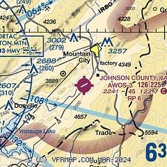
| Elevation: | 2241.1 ft. / 683 m (estimated) |
| Variation: | 07W (2010) |
| From city: | 4 miles S of MOUNTAIN CITY, TN |
| Time zone: | UTC -4 (UTC -5 during Standard Time) |
| Zip code: | 37683 |
Airport Operations
| Airport use: | Open to the public |
| Activation date: | 09/1971 |
| Control tower: | no |
| ARTCC: | ATLANTA CENTER |
| FSS: | NASHVILLE FLIGHT SERVICE STATION |
| NOTAMs facility: | BNA (NOTAM-D service available) |
| Attendance: | 0900-1800
AFT HR & SVC - AMGR. |
| Wind indicator: | lighted |
| Segmented circle: | yes |
| Lights: | ACTVT PAPI RWY 07 & 25; MIRL RWY 07/25 - CTAF. |
Airport Communications
| CTAF/UNICOM: | 122.7 |
| WX AWOS-3: | 126.225 (423-727-4365) |
| TRI CITY APPROACH: | 134.425 |
| TRI CITY DEPARTURE: | 134.425 |
| WX AWOS-3PT at 0A9 (17 nm W): | 135.675 (423-543-1801) |
| WX AWOS-3 at VJI (19 nm NW): | 128.125 (276-628-2940) |
| WX AWOS-3 at GEV (20 nm E): | 120.675 (336-982-5555) |
- APCH/DEP SVC PRVDD BY ATLANTA ARTCC ON FREQS 125.15/263.0 (HICKORY RCAG) WHEN TRI-CITIES RGNL APCH CLSD.
Nearby radio navigation aids
| VOR radial/distance | | VOR name | | Freq | | Var |
|---|
| HMVr098/14.7 | | HOLSTON MOUNTAIN VORTAC | | 114.60 | | 04W |
| GZGr155/27.3 | | GLADE SPRING VOR/DME | | 115.55 | | 02W |
| NDB name | | Hdg/Dist | | Freq | | Var | | ID |
|---|
| HEMLOCK | | 011/16.1 | | 320 | | 02W | | BAR | -... .- .-. |
Airport Services
| Fuel available: | 100LL JET-A+ |
| Parking: | hangars and tiedowns |
| Airframe service: | MAJOR |
| Powerplant service: | MAJOR |
Runway Information
Runway 7/25
| Dimensions: | 4498 x 75 ft. / 1371 x 23 m |
| Surface: | asphalt, in good condition |
| Weight bearing capacity: | | Double wheel: | 26.0 | | Double tandem: | 37.0 |
|
| Runway edge lights: | medium intensity |
| RUNWAY 7 | | RUNWAY 25 |
| Latitude: | 36-24.875322N | | 36-25.266085N |
| Longitude: | 081-49.897715W | | 081-49.118322W |
| Elevation: | 2240.3 ft. | | 2241.1 ft. |
| Traffic pattern: | right | | left |
| Runway heading: | 065 magnetic, 058 true | | 245 magnetic, 238 true |
| Markings: | nonprecision, in good condition | | nonprecision, in good condition |
| Visual slope indicator: | 2-light PAPI on left (4.00 degrees glide path)
RWY 07 PAPI DOES NOT PRVD OBSTN CLNC BYD 1.4 NM FM THR. PAPI RWY 07 UNUSBL BYD 5 DEGS LEFT OF CNTRLN. | | 2-light PAPI on left (4.00 degrees glide path)
PAPI RWY 25 DOES NOT PRVD OBSTN CLNC BYD 1.4 NM FM THR. RWY 25 PAPI UNUSBL BYD 8 DEGS LEFT OF CNTRLN. |
| Runway end identifier lights: | no | | no |
| Touchdown point: | yes, no lights | | yes, no lights |
| Obstructions: | 34 ft. tree, 784 ft. from runway, 193 ft. left of centerline, 17:1 slope to clear | | 97 ft. tree, 1797 ft. from runway, 423 ft. right of centerline, 16:1 slope to clear |
Airport Ownership and Management from official FAA records
| Ownership: | Publicly-owned |
| Owner: | JOHNSON COUNTY
CO COURTHSE; 222 W MAIN ST
MOUNTAIN CITY, TN 37683
Phone 423-727-9696 |
| Manager: | DAVE GARRIS
611 AIRPORT ROAD
MOUNTAIN CITY, TN 37683
Phone 423-727-1223 |
Additional Remarks
| - | MT TRRN & HIGH PEAKS ALL QUADS; TSNT NIGHT OPS NOT RCMDD. |
| - | DEER & BIRDS INVOF ARPT. |
| - | COLD TEMPERATURE AIRPORT. ALTITUDE CORRECTION REQUIRED AT OR BELOW -9C. |
| - | FOR CD CTC ATLANTA ARTCC AT 770-210-7692. |
Instrument Procedures
NOTE: All procedures below are presented as PDF files. If you need a reader for these files, you should download the free Adobe Reader.NOT FOR NAVIGATION. Please procure official charts for flight.
FAA instrument procedures published for use from 09 July 2026 at 0901Z to 06 August 2026 at 0900Z.
IAPs - Instrument Approach Procedures |
|---|
| RNAV (GPS) RWY 07 | |
download (436KB) |
| RNAV (GPS) RWY 25 | |
download (397KB) |
| NOTE: Special Take-Off Minimums/Departure Procedures apply | |
download (385KB) |
Other nearby airports with instrument procedures:
0A9 - William B Greene Jr Regional Airport (17 nm W)
KVJI - Virginia Highlands Airport (19 nm NW)
KGEV - Ashe County Airport (20 nm E)
KTRI - Tri-Cities Airport (28 nm W)
KMKJ - Mountain Empire Airport (37 nm NE)
|
|

Road maps at:
MapQuest
Bing
Google
| Aerial photo |
|---|
WARNING: Photo may not be current or correct

Do you have a better or more recent aerial photo of Johnson County Airport that you would like to share? If so, please send us your photo.
|
| Sectional chart |
|---|
|
| Airport distance calculator |
|---|
|
|
| Sunrise and sunset |
|---|
|
Times for 24-Jul-2026
| | Local
(UTC-4) | | Zulu
(UTC) |
|---|
| Morning civil twilight | | 05:59 | | 09:59 |
| Sunrise | | 06:28 | | 10:28 |
| Sunset | | 20:39 | | 00:39 |
| Evening civil twilight | | 21:08 | | 01:08 |
|
| Current date and time |
|---|
| Zulu (UTC) | 25-Jul-2026 03:59:38 |
|---|
| Local (UTC-4) | 24-Jul-2026 23:59:38 |
|---|
|
| METAR |
|---|
KTNB
16nm SE | 118.525 828-268-8921
250335Z 1SM -RA 17/17 A3023 RMK AO2 P0001 T01700170
|
K0A9
17nm W | 250335Z AUTO RMK AO2
|
KVJI
18nm NW | 250335Z AUTO 03005KT 10SM SCT085 SCT110 20/19 A3015 RMK AO2
|
KGEV
20nm E | 250335Z AUTO 00000KT 1/4SM FG OVC003 17/17 A3023 RMK AO2 T01670166
|
KTRI
28nm W | 250353Z 00000KT 10SM FEW010 BKN065 OVC110 22/20 A3012 RMK AO2 SLP174 T02170200
|
|
| TAF |
|---|
KTRI
28nm W | 241736Z 2418/2518 VRB03KT P6SM BKN025 FM242300 VRB03KT P6SM SCT035 FM250400 00000KT P6SM FEW009 OVC025 FM251500 29002KT P6SM SCT015 BKN040
|
|
| NOTAMs |
|---|
NOTAMs are issued by the DoD/FAA and will open in a separate window not controlled by AirNav.
|
|

