FAA INFORMATION EFFECTIVE 15 MAY 2025
Location
| FAA Identifier: | 78B |
| Lat/Long: | 45-39-15.1710N 068-56-58.1560W
45-39.252850N 068-56.969267W
45.6542142,-68.9494878
(estimated) |
| Elevation: | 500 ft. / 152 m (estimated) |
| Variation: | 19W (1985) |
| Time zone: | UTC -4 (UTC -5 during Standard Time) |
| Zip code: | 04462 |
Seaplane Base Operations
| Seaplane Base use: | Open to the public |
| Activation date: | 05/1949 |
| Control tower: | no |
| ARTCC: | BOSTON CENTER |
| FSS: | BANGOR FLIGHT SERVICE STATION |
| NOTAMs facility: | BGR (NOTAM-D service available) |
| Attendance: | CONTINUOUS |
| Wind indicator: | no |
| Segmented circle: | no |
Seaplane Base Communications
| CTAF: | 122.9 |
| WX ASOS at MLT (11 nm E): | 135.225 (207-723-8396) |
Nearby radio navigation aids
| VOR radial/distance | | VOR name | | Freq | | Var |
|---|
| MLTr303/18.7 | | MILLINOCKET VOR/DME | | 117.90 | | 20W |
| NDB name | | Hdg/Dist | | Freq | | Var | | ID |
|---|
| MILNOT | | 288/16.7 | | 344 | | 17W | | LNT | .-.. -. - |
Seaplane Base Services
| Parking: | buoy |
| Airframe service: | NONE |
| Powerplant service: | NONE |
Runway Information
Runway NW/SE
| Dimensions: | 4000 x 500 ft. / 1219 x 152 m |
| Surface: | water |
| RUNWAY NW | | RUNWAY SE |
| Traffic pattern: | left | | left |
| Obstructions: | 60 ft. trees, 1200 ft. from runway, 100 ft. left of centerline, 20:1 slope to clear | | 60 ft. trees, 1200 ft. from runway, 125 ft. right of centerline, 20:1 slope to clear |
Runway E/W
| Dimensions: | 3000 x 500 ft. / 914 x 152 m |
| Surface: | water |
| Operational restrictions: | SHALLOW AREAS W/ ROCKS NEAR ISLAND WEST OF THE NW/SE SEA LANE. |
| RUNWAY E | | RUNWAY W |
| Traffic pattern: | left | | left |
| Runway end identifier lights: | no | | no |
| Obstructions: | 60 ft. trees, 1200 ft. from runway, 100 ft. right of centerline, 20:1 slope to clear | | 60 ft. trees, 1200 ft. from runway, 100 ft. right of centerline, 20:1 slope to clear |
Seaplane Base Ownership and Management from official FAA records
| Ownership: | Privately-owned |
| Owner: | KATY WOOD & BUD UTECHT
BUCKHORN CAMPS-MIDDLE JO-MARY LAKE, T-4 INDIAN PURCHASE TWP P.O.BOX 240
MILLINOCKET, ME 04462
Phone 207-460-6134 |
| Manager: | KATY WOOD & BUD UTECHT
BUCKHORN CAMPS-MIDDLE JO-MARY LAKE, T-4 INDIAN PRCHASE TWP. BOX 240
MILLINOCKET, ME 04462
Phone 207-723-1548
INFO@BUCKHORNCAMPS.COM. |
Additional Remarks
| - | MANY SHALLOW ROCKY AREAS DURING LOW WATER CONDITIONS IN MIDDLE OF LAKE. |
| - | MANY SHALLOW ROCKY AREAS AROUND THE DOCKING AREA. |
| - | FOR CD CTC BOSTON ARTCC AT 603-879-6859. |
| - | UNUSUAL POSTAL ADS: BUCKHORN CAMPS MIDDLE JO-MARY LAKE, T-4 INDIAN PURCHASE TOWNSHIP, P.O. BOX 240 MILLINOCKET MAINE 04462. CELL SVC SPORADIC: 207-723-1548 (LODGE) 207-460-6134 (CELL). RCMD E-MAIL:INFO@BUCKHORNCAMPS.COM. |
Instrument Procedures
There are no published instrument procedures at 78B.
Some nearby airports with instrument procedures:
KMLT - Millinocket Municipal Airport (11 nm E)
KLRG - Lincoln Regional Airport (25 nm SE)
3B1 - Greenville Municipal Airport (28 nm SW)
52B - Moosehead Aero Marine Seaplane Base (30 nm W)
1B0 - Dexter Regional Airport (41 nm S)
|
|

Road maps at:
MapQuest
Bing
Google
| Aerial photo |
|---|
WARNING: Photo may not be current or correct

Do you have a better or more recent aerial photo of Buckhorn Camps Seaplane Base that you would like to share? If so, please send us your photo.
|
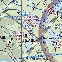
| Sectional chart |
|---|
|
| Airport distance calculator |
|---|
|
|
| Sunrise and sunset |
|---|
|
Times for 24-May-2025
| | Local
(UTC-4) | | Zulu
(UTC) |
|---|
| Morning civil twilight | | 04:21 | | 08:21 |
| Sunrise | | 04:57 | | 08:57 |
| Sunset | | 20:09 | | 00:09 |
| Evening civil twilight | | 20:45 | | 00:45 |
|
| Current date and time |
|---|
| Zulu (UTC) | 25-May-2025 01:11:12 |
|---|
| Local (UTC-4) | 24-May-2025 21:11:12 |
|---|
|
| METAR |
|---|
KMLT
10nm E | 250053Z AUTO 00000KT 10SM BKN055 OVC075 08/07 A2984 RMK AO2 SLP112 T00780072
|
|
| NOTAMs |
|---|
NOTAMs are issued by the DoD/FAA and will open in a separate window not controlled by AirNav.
|
|


