FAA INFORMATION EFFECTIVE 14 MAY 2026
Location
| FAA Identifier: | 1B0 |
| Lat/Long: | 45-00-16.2270N 069-14-14.7720W
45-00.270450N 069-14.246200W
45.0045075,-69.2374367
(estimated) |
| Elevation: | 533.3 ft. / 162.5 m (surveyed) |
| Variation: | 18W (1995) |
| From city: | 3 miles E of DEXTER, ME |
| Time zone: | UTC -4 (UTC -5 during Standard Time) |
| Zip code: | 04930 |
Airport Operations
| Airport use: | Open to the public |
| Activation date: | 03/1948 |
| Control tower: | no |
| ARTCC: | BOSTON CENTER |
| FSS: | BANGOR FLIGHT SERVICE STATION |
| NOTAMs facility: | BGR (NOTAM-D service available) |
| Attendance: | UNATNDD |
| Wind indicator: | lighted |
| Segmented circle: | yes |
| Lights: | ACTVT MIRL RWY 16/34 - CTAF. |
| Beacon: | white-green (lighted land airport)
Operates sunset to sunrise. |
Airport Communications
| CTAF/UNICOM: | 122.8 |
| BANGOR APPROACH: | 118.925 |
| BANGOR DEPARTURE: | 118.925 |
Nearby radio navigation aids
| VOR radial/distance | | VOR name | | Freq | | Var |
|---|
| BGRr321/18.3 | | BANGOR VORTAC | | 114.80 | | 19W |
| NDB name | | Hdg/Dist | | Freq | | Var | | ID |
|---|
| BURNHAM | | 034/19.1 | | 348 | | 18W | | BUP | -... ..- .--. |
Airport Services
| Fuel available: | 100LL MOGAS
100LL:24 HR FUEL WITH MAJOR CREDIT CARD, NO ETHANOL IN MOGAS. |
| Parking: | tiedowns |
| Airframe service: | NONE |
| Powerplant service: | NONE |
| Bottled oxygen: | NONE |
| Bulk oxygen: | NONE |
Runway Information
Runway 16/34
| Dimensions: | 3008 x 75 ft. / 917 x 23 m |
| Surface: | asphalt, in good condition |
| Weight bearing capacity: | |
| Runway edge lights: | medium intensity |
| RUNWAY 16 | | RUNWAY 34 |
| Latitude: | 45-00.489915N | | 45-00.114843N |
| Longitude: | 069-14.457312W | | 069-14.001920W |
| Elevation: | 520.8 ft. | | 523.7 ft. |
| Traffic pattern: | left | | left |
| Runway heading: | 157 magnetic, 139 true | | 337 magnetic, 319 true |
| Markings: | nonprecision, in good condition | | nonprecision, in good condition |
| Runway end identifier lights: | no | | no |
| Touchdown point: | yes, no lights | | yes, no lights |
Runway 7/25
| Dimensions: | 1249 x 120 ft. / 381 x 37 m |
| Surface: | turf |
| RUNWAY 7 | | RUNWAY 25 |
| Latitude: | 45-00.126662N | | 45-00.260487N |
| Longitude: | 069-14.396173W | | 069-14.176168W |
| Elevation: | 533.3 ft. | | 526.4 ft. |
| Traffic pattern: | left | | left |
| Runway heading: | 067 magnetic, 049 true | | 247 magnetic, 229 true |
| Markings: | , in fair condition | | , in fair condition |
| Touchdown point: | yes, no lights | | yes, no lights |
Airport Ownership and Management from official FAA records
| Ownership: | Publicly-owned |
| Owner: | TOWN OF DEXTER
TOWN OFFICE BLDG, 23 MAIN
DEXTER, ME 04930
Phone 207-924-7351 |
| Manager: | ROGER NELSON
129 OLD BANGOR RD
NEWPORT, ME 04953
Phone 207-270-0239 |
Additional Remarks
| - | WILDLIFE ON OR INVOF ARPT. |
| - | FOR CD CTC BANGOR APCH AT 207-561-2500 EXTN 1. |
| - | TXL A CLSD TO ACFT WITH WINGSPAN GTR THAN 36 FT. |
| - | TXL A RSTRD TO BASED ACFT ONLY. |
Instrument Procedures
NOTE: All procedures below are presented as PDF files. If you need a reader for these files, you should download the free Adobe Reader.NOT FOR NAVIGATION. Please procure official charts for flight.
FAA instrument procedures published for use from 14 May 2026 at 0901Z to 11 June 2026 at 0900Z.
IAPs - Instrument Approach Procedures |
|---|
| RNAV (GPS) RWY 16 | |
download (201KB) |
| RNAV (GPS) RWY 34 | |
download (206KB) |
| NOTE: Special Take-Off Minimums/Departure Procedures apply | |
download (178KB) |
Other nearby airports with instrument procedures:
2B7 - Pittsfield Municipal Airport (15 nm S)
KBGR - Bangor International Airport (21 nm SE)
KOLD - Dewitt Field/Old Town Municipal Airport (24 nm E)
3B1 - Greenville Municipal Airport (31 nm NW)
KOWK - Central Maine/Norridgewock Airport (32 nm SW)
|
|

Road maps at:
MapQuest
Bing
Google
| Aerial photo |
|---|
WARNING: Photo may not be current or correct
 Photo by Robert W. Finlay
Taken late May 2017
looking northeast.
Photo by Robert W. Finlay
Taken late May 2017
looking northeast.
Do you have a better or more recent aerial photo of Dexter Regional Airport that you would like to share? If so, please send us your photo.
|
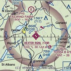
| Sectional chart |
|---|
|
| Airport distance calculator |
|---|
|
|
| Sunrise and sunset |
|---|
|
Times for 09-Jun-2026
| | Local
(UTC-4) | | Zulu
(UTC) |
|---|
| Morning civil twilight | | 04:14 | | 08:14 |
| Sunrise | | 04:51 | | 08:51 |
| Sunset | | 20:21 | | 00:21 |
| Evening civil twilight | | 20:58 | | 00:58 |
|
| Current date and time |
|---|
| Zulu (UTC) | 09-Jun-2026 10:19:27 |
|---|
| Local (UTC-4) | 09-Jun-2026 06:19:27 |
|---|
|
| METAR |
|---|
KBGR
22nm SE | 090953Z 00000KT 10SM FEW150 SCT250 11/10 A3010 RMK AO2 SLP191 T01110100
|
KGNR
31nm NW | 090956Z AUTO 00000KT 16/09 A3010 RMK AO1 SLP191 T01560089
|
KWVL
35nm SW | 090956Z AUTO 00000KT 10SM CLR 12/10 A3010 RMK AO2 SLP197 T01170100
|
|
| TAF |
|---|
KBGR
22nm SE | 090520Z 0906/1006 VRB03KT P6SM FEW250 FM091500 28007G15KT P6SM FEW170 FM100000 VRB03KT P6SM FEW250
|
|
| NOTAMs |
|---|
NOTAMs are issued by the DoD/FAA and will open in a separate window not controlled by AirNav.
|
|

