FAA INFORMATION EFFECTIVE 10 JULY 2025
Location
| FAA Identifier: | OLD |
| Lat/Long: | 44-57-08.4060N 068-40-28.1840W
44-57.140100N 068-40.469733W
44.9523350,-68.6744956
(estimated) |
| Elevation: | 126.5 ft. / 38.6 m (surveyed) |
| Variation: | 15W (2025) |
| From city: | 2 miles NW of OLD TOWN, ME |
| Time zone: | UTC -4 (UTC -5 during Standard Time) |
| Zip code: | 04468 |
Airport Operations
| Airport use: | Open to the public |
| Activation date: | 11/1942 |
| Control tower: | no |
| ARTCC: | BOSTON CENTER |
| FSS: | BANGOR FLIGHT SERVICE STATION |
| NOTAMs facility: | BGR (NOTAM-D service available) |
| Attendance: | 0800-1700 |
| Wind indicator: | lighted |
| Segmented circle: | yes |
| Lights: | ACTVT REIL RWY 04; PAPI RWY 22 & 30; MIRL RWY 04/22 & 12/30 - CTAF. |
| Beacon: | white-green (lighted land airport)
Operates sunset to sunrise. |
Airport Communications
| CTAF/UNICOM: | 122.8 |
| BANGOR APPROACH: | 118.925 |
| BANGOR DEPARTURE: | 118.925 |
| WX ASOS at BGR (11 nm SW): | 127.75 (207-561-2515) |
Nearby radio navigation aids
| VOR radial/distance | | VOR name | | Freq | | Var |
|---|
| BGRr071/10.8 | | BANGOR VORTAC | | 114.80 | | 19W |
| MLTr210/38.7 | | MILLINOCKET VOR/DME | | 117.90 | | 20W |
| NDB name | | Hdg/Dist | | Freq | | Var | | ID |
|---|
| BURNHAM | | 080/32.9 | | 348 | | 18W | | BUP | -... ..- .--. |
Airport Services
| Fuel available: | 100LL JET-A
A:24 HR FUEL SELF-SVC WITH MAJOR CREDIT CARD. CREDIT CARD ALSO AVBL AT DOCK. |
| Parking: | hangars and tiedowns |
| Airframe service: | MAJOR |
| Powerplant service: | MAJOR |
| Bulk oxygen: | NONE |
Runway Information
Runway 12/30
| Dimensions: | 4001 x 75 ft. / 1220 x 23 m |
| Surface: | asphalt, in good condition |
| Weight bearing capacity: | |
| Runway edge lights: | medium intensity |
| Runway edge markings: | FADED. |
| RUNWAY 12 | | RUNWAY 30 |
| Latitude: | 44-57.219370N | | 44-57.144492N |
| Longitude: | 068-40.966142W | | 068-40.044857W |
| Elevation: | 124.7 ft. | | 119.1 ft. |
| Traffic pattern: | left | | left |
| Runway heading: | 112 magnetic, 097 true | | 292 magnetic, 277 true |
| Displaced threshold: | no | | 689 ft. |
| Markings: | nonprecision, in poor condition | | nonprecision, in poor condition |
| Visual slope indicator: | | | 4-light PAPI on left (4.00 degrees glide path) |
| Runway end identifier lights: | no | | no |
| Touchdown point: | yes, no lights | | yes, no lights |
| Obstructions: | 22 ft. trees, 442 ft. from runway, 255 ft. right of centerline, 11:1 slope to clear
35:1 TO DTHR. | | 67 ft. trees, 1400 ft. from runway, 280 ft. right of centerline, 18:1 slope to clear |
Runway 4/22
| Dimensions: | 2802 x 75 ft. / 854 x 23 m |
| Surface: | asphalt, in good condition |
| Weight bearing capacity: | | Single wheel: | 37.0 | | Double wheel: | 45.0 |
|
| Runway edge lights: | medium intensity |
| Runway edge markings: | FADED. |
| RUNWAY 4 | | RUNWAY 22 |
| Latitude: | 44-56.866595N | | 44-57.294073N |
| Longitude: | 068-40.540318W | | 068-40.297022W |
| Elevation: | 125.9 ft. | | 122.2 ft. |
| Traffic pattern: | left | | left |
| Runway heading: | 037 magnetic, 022 true | | 217 magnetic, 202 true |
| Markings: | nonprecision, in poor condition | | nonprecision, in poor condition |
| Visual slope indicator: | | | 4-light PAPI on left (4.00 degrees glide path) |
| Runway end identifier lights: | yes | | no |
| Touchdown point: | yes, no lights | | yes, no lights |
| Obstructions: | 76 ft. trees, 1650 ft. from runway, 280 ft. right of centerline, 19:1 slope to clear | | none |
Runway 17W/35W
| Dimensions: | 8400 x 100 ft. / 2560 x 30 m |
| Surface: | water |
| RUNWAY 17W | | RUNWAY 35W |
| Elevation: | 102.0 ft. | | 102.0 ft. |
| Traffic pattern: | left | | left |
| Runway end identifier lights: | no | | no |
Airport Ownership and Management from official FAA records
| Ownership: | Publicly-owned |
| Owner: | CITY OF OLD TOWN
265 MAIN ST
OLD TOWN, ME 04468
Phone 207-827-3965
ALTN FONE NR: BILL MAYO, CITY MGR 207-827-3965-EXT 201. |
| Manager: | MILES FRANCES
100 AIRPORT RD, PO BOX 558
OLD TOWN, ME 04468
Phone 207-852-9239
LFARRAR@OLD-TOWN.ORG. |
Additional Remarks
| - | WATERFOWL, TURKEY & DEER ON & INVOF ARPT. |
| - | FBO CLSD SUN. |
| - | FOR CD CTC BANGOR APCH AT 207-561-2500 EXT 1. |
Instrument Procedures
NOTE: All procedures below are presented as PDF files. If you need a reader for these files, you should download the free Adobe Reader.NOT FOR NAVIGATION. Please procure official charts for flight.
FAA instrument procedures published for use from 10 July 2025 at 0901Z to 07 August 2025 at 0900z.
IAPs - Instrument Approach Procedures |
|---|
| RNAV (GPS) RWY 12 | |
download (265KB) |
| RNAV (GPS) RWY 22 | |
download (234KB) |
| RNAV (GPS) RWY 30 | |
download (255KB) |
| VOR RWY 22 | |
download (212KB) |
| NOTE: Special Take-Off Minimums/Departure Procedures apply | |
download (546KB) |
Other nearby airports with instrument procedures:
KBGR - Bangor International Airport (11 nm SW)
1B0 - Dexter Regional Airport (24 nm W)
KLRG - Lincoln Regional Airport (25 nm N)
2B7 - Pittsfield Municipal Airport (32 nm W)
43B - Deblois Flight Strip (32 nm SE)
|
|

Road maps at:
MapQuest
Bing
Google
| Aerial photo |
|---|
WARNING: Photo may not be current or correct
 Photo by Pete Chaisson- Portland Flight Services
Photo taken 24-Aug-2014
looking west.
Photo by Pete Chaisson- Portland Flight Services
Photo taken 24-Aug-2014
looking west.
Do you have a better or more recent aerial photo of Dewitt Field/Old Town Municipal Airport that you would like to share? If so, please send us your photo.
|
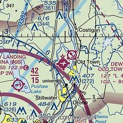
| Sectional chart |
|---|
|
| Airport distance calculator |
|---|
|
|
| Sunrise and sunset |
|---|
|
Times for 13-Jul-2025
| | Local
(UTC-4) | | Zulu
(UTC) |
|---|
| Morning civil twilight | | 04:26 | | 08:26 |
| Sunrise | | 05:02 | | 09:02 |
| Sunset | | 20:19 | | 00:19 |
| Evening civil twilight | | 20:55 | | 00:55 |
|
| Current date and time |
|---|
| Zulu (UTC) | 13-Jul-2025 06:54:57 |
|---|
| Local (UTC-4) | 13-Jul-2025 02:54:57 |
|---|
|
| METAR |
|---|
KBGR
11nm SW | 130553Z 18008KT 3SM BR OVC004 16/16 A3015 RMK AO2 SLP205 T01610156 10183 20161 56005
|
|
| TAF |
|---|
KBGR
11nm SW | 130520Z 1306/1406 18005KT 1SM BR OVC003 FM131300 18006KT P6SM BKN012 FM131500 18009KT P6SM BKN025 FM131600 18009KT P6SM SCT035 FM140200 18008KT P6SM BKN028 FM140500 19005KT 1SM BR OVC022
|
|
| NOTAMs |
|---|
NOTAMs are issued by the DoD/FAA and will open in a separate window not controlled by AirNav.
|
|


