FAA INFORMATION EFFECTIVE 14 MAY 2026
Location
| FAA Identifier: | 78R |
| Lat/Long: | 31-32-25.5500N 094-10-12.2400W
31-32.425833N 094-10.204000W
31.5404306,-94.1700667
(estimated) |
| Elevation: | 443 ft. / 135.0 m (surveyed) |
| Variation: | 05E (1985) |
| From city: | 3 miles W of SAN AUGUSTINE, TX |
| Time zone: | UTC -5 (UTC -6 during Standard Time) |
| Zip code: | 75972 |
Airport Operations
| Airport use: | Open to the public |
| Activation date: | 06/1970 |
| Control tower: | no |
| ARTCC: | HOUSTON CENTER |
| FSS: | MONTGOMERY COUNTY FLIGHT SERVICE STATION |
| NOTAMs facility: | CXO (NOTAM-D service available) |
| Attendance: | UNATNDD |
| Wind indicator: | lighted |
| Segmented circle: | yes |
| Lights: | MIRL RWY 17/35 PRESET LOW INTST, TO INCR INTST ACTVT - CTAF. |
| Beacon: | white-green (lighted land airport)
ACTVT ROTG BCN - CTAF. |
Airport Communications
| CTAF: | 122.9 |
| WX AWOS-3PT at F17 (17 nm N): | 128.775 (936-598-3355) |
Nearby radio navigation aids
| VOR radial/distance | | VOR name | | Freq | | Var |
|---|
| LFKr046/36.0 | | LUFKIN VORTAC | | 112.10 | | 05E |
Airport Services
| Airframe service: | NONE |
| Powerplant service: | NONE |
| Bottled oxygen: | NONE |
| Bulk oxygen: | NONE |
Runway Information
Runway 17/35
| Dimensions: | 3800 x 50 ft. / 1158 x 15 m |
| Surface: | asphalt, in poor condition
CRACKING, POTHOLES LOOSE STONES. |
| Weight bearing capacity: | |
| Runway edge lights: | medium intensity |
| RUNWAY 17 | | RUNWAY 35 |
| Latitude: | 31-32.739167N | | 31-32.112500N |
| Longitude: | 094-10.206667W | | 094-10.201333W |
| Elevation: | 443.0 ft. | | 393.0 ft. |
| Traffic pattern: | left | | left |
| Runway heading: | 175 magnetic, 180 true | | 355 magnetic, 360 true |
| Displaced threshold: | 124 ft. | | no |
| Markings: | basic, in fair condition | | basic, in fair condition |
| Obstructions: | 65 ft. trees, 388 ft. from runway, 145 ft. left and right of centerline, 2:1 slope to clear
10 FT BRUSH, 130 FT DSTC, 125 FT L/R. | | 10 ft. fence, 210 ft. from runway, 55 ft. left of centerline, 1:1 slope to clear |
Airport Ownership and Management from official FAA records
| Ownership: | Publicly-owned |
| Owner: | SAN AUGUSTINE COUNTY
100 W. COLUMBIA ST, ROOM 105
SAN AUGUSTINE, TX 75972
Phone 936-275-2762 |
| Manager: | JEFF BOYD
100 W. COLUMBIA
SAN AUGUSTINE, TX 75972
Phone 936-275-2762
EMERG PHONE: 936-275-2424, SHERIFF OFC. |
Additional Remarks
| - | FOR CD CTC HOUSTON ARTCC AT 281-230-5622. |
| - | NO LINE OF SIGHT BETWEEN RWY ENDS. |
Instrument Procedures
There are no published instrument procedures at 78R.
Some nearby airports with instrument procedures:
F17 - Center Municipal Airport (17 nm N)
KOCH - Nacogdoches A L Mangham Jr. Regional Airport (28 nm W)
KLFK - Angelina County Airport (35 nm SW)
3R4 - Hart Airport (35 nm E)
3F3 - C E 'Rusty' Williams Airport (38 nm NE)
|
|

Road maps at:
MapQuest
Bing
Google
| Aerial photo |
|---|
WARNING: Photo may not be current or correct

Do you have a better or more recent aerial photo of San Augustine County Airport that you would like to share? If so, please send us your photo.
|
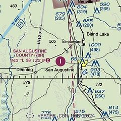
| Sectional chart |
|---|
|
| Airport distance calculator |
|---|
|
|
| Sunrise and sunset |
|---|
|
Times for 07-Jun-2026
| | Local
(UTC-5) | | Zulu
(UTC) |
|---|
| Morning civil twilight | | 05:45 | | 10:45 |
| Sunrise | | 06:12 | | 11:12 |
| Sunset | | 20:19 | | 01:19 |
| Evening civil twilight | | 20:47 | | 01:47 |
|
| Current date and time |
|---|
| Zulu (UTC) | 07-Jun-2026 15:16:28 |
|---|
| Local (UTC-5) | 07-Jun-2026 10:16:28 |
|---|
|
| METAR |
|---|
KF17
17nm N | 071455Z AUTO 17006KT 10SM OVC014 25/23 A2990 RMK AO2
|
KOCH
28nm W | 071456Z AUTO 17010G16KT OVC014 27/25 A2988 RMK AO2 SLP118 6//// T02720250 53002 PWINO RVRNO $
|
KLFK
35nm SW | 071500Z AUTO 16012G19KT 10SM BKN015 BKN027 OVC033 28/25 A2988 RMK AO2 T02830250 $
|
|
| TAF |
|---|
KLFK
35nm SW | 071140Z 0712/0812 14003KT P6SM VCSH BKN012 BKN029 FM071600 18009KT P6SM VCTS BKN015CB OVC150 FM071900 19010KT P6SM VCTS BKN030CB OVC150 FM080200 17006KT P6SM SCT015 BKN150 BKN250 FM080800 15006KT P6SM OVC015 FM081000 14005KT 6SM BR OVC007
|
|
| NOTAMs |
|---|
NOTAMs are issued by the DoD/FAA and will open in a separate window not controlled by AirNav.
|
|

