FAA INFORMATION EFFECTIVE 27 NOVEMBER 2025
Location
| FAA Identifier: | 3R4 |
| Lat/Long: | 31-32-39.2900N 093-29-01.7000W
31-32.654833N 093-29.028333W
31.5442472,-93.4838056
(estimated) |
| Elevation: | 318.5 ft. / 97.1 m (surveyed) |
| Variation: | 04E (1990) |
| From city: | 2 miles SW of MANY, LA |
| Time zone: | UTC -6 (UTC -5 during Daylight Saving Time) |
| Zip code: | 71449 |
Airport Operations
| Airport use: | Open to the public |
| Activation date: | 04/1940 |
| Control tower: | no |
| ARTCC: | HOUSTON CENTER |
| FSS: | DE RIDDER FLIGHT SERVICE STATION |
| NOTAMs facility: | DRI (NOTAM-D service available) |
| Attendance: | UNATNDD |
| Wind indicator: | lighted |
| Segmented circle: | no |
| Lights: | DUSK-DAWN. MIRL RY 12/30, REIL RYS 12 & 30 PRESET LOW INTST DUSK-DAWN; TO INCR INTST ACTVT - CTAF. |
| Beacon: | white-green (lighted land airport)
BCN LCTD .44 MI FM APCH END RWY 12. Operates sunset to sunrise. |
Airport Communications
| CTAF/UNICOM: | 122.8 |
| POLK APPROACH: | 123.7 |
| POLK DEPARTURE: | 123.7 |
Nearby radio navigation aids
| VOR radial/distance | | VOR name | | Freq | | Var |
|---|
| FXUr330/(29.3) | | POLK VOR | | 108.40 | | 02E |
| NDB name | | Hdg/Dist | | Freq | | Var | | ID |
|---|
| NATCHITOCHES | | 248/21.8 | | 407 | | 04E | | OOC | --- --- -.-. |
| AMASON | | 113/38.3 | | 341 | | 04E | | CZJ | -.-. --.. .--- |
Airport Services
| Fuel available: | 100LL
100LL:SELF SERVICE FUEL AVBL AFT HRS WITH CREDIT CARD. |
| Parking: | tiedowns |
| Airframe service: | NONE |
| Powerplant service: | NONE |
| Bottled oxygen: | NONE |
| Bulk oxygen: | NONE |
Runway Information
Runway 12/30
| Dimensions: | 4402 x 75 ft. / 1342 x 23 m |
| Surface: | asphalt, in fair condition |
| Weight bearing capacity: | |
| Runway edge lights: | medium intensity |
| RUNWAY 12 | | RUNWAY 30 |
| Latitude: | 31-32.841817N | | 31-32.467967N |
| Longitude: | 093-29.391738W | | 093-28.665080W |
| Elevation: | 318.3 ft. | | 307.2 ft. |
| Traffic pattern: | left | | left |
| Runway heading: | 117 magnetic, 121 true | | 297 magnetic, 301 true |
| Markings: | nonprecision, in fair condition | | nonprecision, in fair condition |
| Visual slope indicator: | 2-light PAPI on left (3.00 degrees glide path) | | 2-light PAPI on left (3.50 degrees glide path) |
| Runway end identifier lights: | yes | | yes |
| Touchdown point: | yes, no lights | | yes, no lights |
| Obstructions: | 38 ft. trees, 1681 ft. from runway, 227 ft. right of centerline, 38:1 slope to clear | | 78 ft. trees, 1830 ft. from runway, 20:1 slope to clear |
Airport Ownership and Management from official FAA records
| Ownership: | Publicly-owned |
| Owner: | CITY OF MANY
PO BOX 1330
MANY, LA 71449
Phone 318-256-3651 |
| Manager: | MILES GREER
950 AIRPORT RD
MANY, LA 71449
Phone 318-256-5857 |
Additional Remarks
| - | GCO AVBL ON FREQ 135.075 THRU POLK APCH AND DE RIDDER FSS. |
| - | FOR CD CTC IF UNA VIA GCO CTC POLK APCH AT 337-531-2352. |
Instrument Procedures
NOTE: All procedures below are presented as PDF files. If you need a reader for these files, you should download the free Adobe Reader.NOT FOR NAVIGATION. Please procure official charts for flight.
FAA instrument procedures published for use from 27 November 2025 at 0901Z to 25 December 2025 at 0900Z.
IAPs - Instrument Approach Procedures |
|---|
| RNAV (GPS) RWY 12 | |
download (210KB) |
| RNAV (GPS) RWY 30 | |
download (196KB) |
| NOTE: Special Take-Off Minimums/Departure Procedures apply | |
download (116KB) |
Other nearby airports with instrument procedures:
KIER - Natchitoches Regional Airport (23 nm NE)
L39 - Leesville Airport (24 nm S)
0R7 - The Red River Airport (28 nm N)
KPOE - Maks Army Air Field (34 nm SE)
3F3 - C E 'Rusty' Williams Airport (35 nm NW)
|
|

Road maps at:
MapQuest
Bing
Google
| Aerial photo |
|---|
WARNING: Photo may not be current or correct
 Photo by Carl Hennigan
Taken in May 2007
Photo by Carl Hennigan
Taken in May 2007
Do you have a better or more recent aerial photo of Hart Airport that you would like to share? If so, please send us your photo.
|
| Sectional chart |
|---|
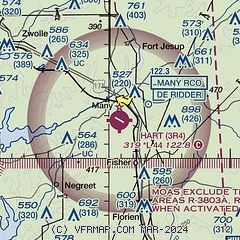
|
| Airport distance calculator |
|---|
|
|
| Sunrise and sunset |
|---|
|
Times for 23-Dec-2025
| | Local
(UTC-6) | | Zulu
(UTC) |
|---|
| Morning civil twilight | | 06:44 | | 12:44 |
| Sunrise | | 07:11 | | 13:11 |
| Sunset | | 17:15 | | 23:15 |
| Evening civil twilight | | 17:42 | | 23:42 |
|
| Current date and time |
|---|
| Zulu (UTC) | 24-Dec-2025 01:49:01 |
|---|
| Local (UTC-6) | 23-Dec-2025 19:49:01 |
|---|
|
| METAR |
|---|
KAQV
8nm N | 240139Z AUTO 00000KT 3SM BR SCT030 16/16 A3027 RMK AO2 T01610156
|
|
| NOTAMs |
|---|
NOTAMs are issued by the DoD/FAA and will open in a separate window not controlled by AirNav.
|
|

