FAA INFORMATION EFFECTIVE 19 MARCH 2026
Location
| FAA Identifier: | 98G |
| Lat/Long: | 43-43-46.2271N 083-27-48.9681W
43-43.770452N 083-27.816135W
43.7295075,-83.4636022
(estimated) |
| Elevation: | 584 ft. / 178 m (estimated) |
| Variation: | 06W (1985) |
| Time zone: | UTC -4 (UTC -5 during Standard Time) |
| Zip code: | 48759 |
Airport Operations
| Airport use: | Open to the public |
| Activation date: | 09/1948 |
| Control tower: | no |
| ARTCC: | CLEVELAND CENTER |
| FSS: | LANSING FLIGHT SERVICE STATION |
| NOTAMs facility: | LAN (NOTAM-D service available) |
| Attendance: | IREG |
| Wind indicator: | lighted |
| Segmented circle: | yes |
| Lights: | ACTVT LIRL RWY 18/36 DUSK-DAWN - CTAF. |
Airport Communications
| CTAF/UNICOM: | 122.8 |
| WX AWOS-3P at CFS (16 nm S): | 119.275 (989-672-4182) |
Nearby radio navigation aids
| VOR radial/distance | | VOR name | | Freq | | Var |
|---|
| MBSr069/29.2 | | SAGINAW VOR/DME | | 114.35 | | 03W |
Airport Services
| Fuel available: | 100LL
100LL:FOR FUEL SVC CTC AMGR. |
| Parking: | tiedowns |
| Airframe service: | MAJOR
AVBL BY PRIOR ARNGMT CALL AMGR. |
| Powerplant service: | MAJOR
AVBL BY PRIOR ARNGMT CALL AMGR. |
| Bottled oxygen: | NONE |
| Bulk oxygen: | NONE |
Runway Information
Runway 18/36
| Dimensions: | 2178 x 50 ft. / 664 x 15 m |
| Surface: | asphalt, in good condition |
| Weight bearing capacity: | |
| Runway edge lights: | low intensity |
| RUNWAY 18 | | RUNWAY 36 |
| Latitude: | 43-43.950000N | | 43-43.593333N |
| Longitude: | 083-27.853333W | | 083-27.800000W |
| Elevation: | 584.0 ft. | | 584.0 ft. |
| Traffic pattern: | left | | left |
| Runway heading: | 180 magnetic, 174 true | | 000 magnetic, 354 true |
| Displaced threshold: | no | | 326 ft. |
| Markings: | basic, in good condition | | basic, in good condition |
| Obstructions: | 5 ft. brush, 200 ft. from runway, 125 ft. right of centerline, 1:1 slope to clear | | 26 ft. rr, 269 ft. from runway, 133 ft. right of centerline, 2:1 slope to clear
APCH RATIO 20:1 TO DTHR. |
Runway 6/24
| Dimensions: | 2060 x 130 ft. / 628 x 40 m |
| Surface: | turf, in good condition |
| Runway edge markings: | 3 FT CONES. |
| RUNWAY 6 | | RUNWAY 24 |
| Latitude: | 43-43.683333N | | 43-43.855000N |
| Longitude: | 083-28.006667W | | 083-27.603333W |
| Elevation: | 583.0 ft. | | 584.0 ft. |
| Traffic pattern: | left | | left |
| Runway heading: | 066 magnetic, 060 true | | 246 magnetic, 240 true |
| Displaced threshold: | 200 ft. | | 485 ft. |
| Obstructions: | 6 ft. brush, 115 ft. left of centerline, 1:1 slope to clear | | 23 ft. rr, 76 ft. from runway, 134 ft. left of centerline, 1:1 slope to clear
APCH RATIO 20:1 TO DTHR. |
Airport Ownership and Management from official FAA records
| Ownership: | Publicly-owned |
| Owner: | SEBEWAING TOWNSHIP
14 E SHARPSTEEN ST
SEBEWAING, MI 48759-1021
Phone 989-883-2120 |
| Manager: | BRENT BOWMAN
14 E SHARPSTEEN ST
SEBEWAING, MI 48759-1021
Phone 989-553-1519 |
Additional Remarks
| - | DEER & LRG BIRDS ON & INVOF ARPT. |
| - | FOR CD CTC GREAT LAKES APCH AT 269-459-3345, WHEN APCH CLSD CTC CLEVELAND ARTCC AT 440-774-0224/0490. |
Instrument Procedures
There are no published instrument procedures at 98G.
Some nearby airports with instrument procedures:
KCFS - Tuscola Area Airport (16 nm S)
KBAX - Huron County Memorial Airport (21 nm E)
3CM - James Clements Municipal Airport (22 nm SW)
KHYX - Saginaw County/H W Browne Airport (25 nm SW)
KMBS - MBS International Airport (29 nm SW)
|
|

Road maps at:
MapQuest
Bing
Google
| Aerial photo |
|---|
WARNING: Photo may not be current or correct
 Photo by Marge Beaver
Photography Plus
1571 Goody Rd.
Muskegon, MI 49441
Photo taken 16-Oct-2010
looking north.
Do you have a better or more recent aerial photo of Sebewaing Township Airport that you would like to share? If so, please send us your photo.
|
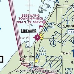
| Sectional chart |
|---|
|
| Airport distance calculator |
|---|
|
|
| Sunrise and sunset |
|---|
|
Times for 12-Apr-2026
| | Local
(UTC-4) | | Zulu
(UTC) |
|---|
| Morning civil twilight | | 06:27 | | 10:27 |
| Sunrise | | 06:57 | | 10:57 |
| Sunset | | 20:12 | | 00:12 |
| Evening civil twilight | | 20:42 | | 00:42 |
|
| Current date and time |
|---|
| Zulu (UTC) | 12-Apr-2026 06:06:58 |
|---|
| Local (UTC-4) | 12-Apr-2026 02:06:58 |
|---|
|
| METAR |
|---|
KCFS
16nm S | 120555Z AUTO 15006KT 10SM OVC090 05/M05 A3032 RMK AO2 10100 20054
|
KBAX
21nm E | 120555Z AUTO 16006KT 10SM OVC110 04/M03 A3033 RMK AO2 T00401030 10064 20040 401071032
|
KHYX
25nm SW | 120555Z AUTO 14010KT 10SM 07/M04 A3029 RMK AO2 PWINO
|
KMBS
29nm SW | 120553Z AUTO 14008KT 10SM BKN085 OVC100 07/M03 A3030 RMK AO2 SLP264 60000 T00721028 10094 20067 58012
|
|
| TAF |
|---|
KMBS
29nm SW | 120538Z 1206/1306 14012KT P6SM OVC100 FM120900 14012KT 3SM -RA BR OVC020 FM121500 18010G22KT 6SM -SHRA BKN025 BKN040 FM122000 21015G30KT P6SM OVC050
|
|
| NOTAMs |
|---|
NOTAMs are issued by the DoD/FAA and will open in a separate window not controlled by AirNav.
|
|

