FAA INFORMATION EFFECTIVE 30 OCTOBER 2025
Location
| FAA Identifier: | BAX |
| Lat/Long: | 43-46-48.8200N 082-59-07.5010W
43-46.813667N 082-59.125017W
43.7802278,-82.9854169
(estimated) |
| Elevation: | 763.8 ft. / 232.8 m (surveyed) |
| Variation: | 05W (1980) |
| From city: | 1 mile S of BAD AXE, MI |
| Time zone: | UTC -5 (UTC -4 during Daylight Saving Time) |
| Zip code: | 48413 |
Airport Operations
| Airport use: | Open to the public |
| Activation date: | 10/1949 |
| Control tower: | no |
| ARTCC: | CLEVELAND CENTER |
| FSS: | LANSING FLIGHT SERVICE STATION |
| NOTAMs facility: | BAX (NOTAM-D service available) |
| Attendance: | MON-FRI 0830-1630
ARPT UNATNDD WEEKENDS & MAJOR HOLS. |
| Wind indicator: | lighted |
| Segmented circle: | yes |
| Lights: | MIRL RYS 04/22 & 17/35 OPER DUSK-2130; TO INCR INTST & AFT 2130 ACTVT - CTAF. ACTVT PAPI RYS 4, 17, 22, & 35 AND REIL RYS 17 & 35 - CTAF. |
| Beacon: | white-green (lighted land airport)
Operates sunset to sunrise. |
Airport Communications
| CTAF/UNICOM: | 123.075 |
| WX AWOS-3: | 118.6 (989-269-4137) |
- APCH/DEP SVC PRVDD BY CLEVELAND ARTCC (ZOB) ON FREQS 127.7/290.425 (FREELAND RCAG).
Airport Services
| Fuel available: | 100LL JET-A+ |
| Parking: | tiedowns |
Runway Information
Runway 17/35
| Dimensions: | 5000 x 75 ft. / 1524 x 23 m |
| Surface: | asphalt/grooved, in excellent condition |
| Weight bearing capacity: | |
| Runway edge lights: | medium intensity |
| RUNWAY 17 | | RUNWAY 35 |
| Latitude: | 43-47.100765N | | 43-46.306667N |
| Longitude: | 082-59.252770W | | 082-58.954543W |
| Elevation: | 763.3 ft. | | 753.6 ft. |
| Traffic pattern: | left | | left |
| Runway heading: | 170 magnetic, 165 true | | 350 magnetic, 345 true |
| Markings: | nonprecision, in good condition | | nonprecision, in good condition |
| Visual slope indicator: | 4-light PAPI on left (3.00 degrees glide path) | | 4-light PAPI on left (3.00 degrees glide path) |
| Runway end identifier lights: | yes | | yes |
| Touchdown point: | yes, no lights | | yes, no lights |
| Obstructions: | 56 ft. trees, 1349 ft. from runway, 250 ft. left of centerline, 20:1 slope to clear | | none |
Runway 4/22
| Dimensions: | 3495 x 75 ft. / 1065 x 23 m |
| Surface: | asphalt, in good condition |
| Weight bearing capacity: | |
| Runway edge lights: | medium intensity |
| RUNWAY 4 | | RUNWAY 22 |
| Latitude: | 43-46.717888N | | 43-47.224072N |
| Longitude: | 082-59.344108W | | 082-58.967063W |
| Elevation: | 755.1 ft. | | 762.6 ft. |
| Traffic pattern: | left | | left |
| Runway heading: | 033 magnetic, 028 true | | 213 magnetic, 208 true |
| Displaced threshold: | 300 ft. | | no |
| Markings: | nonprecision, in good condition | | nonprecision, in good condition |
| Visual slope indicator: | 4-light PAPI on left (3.00 degrees glide path) | | 4-light PAPI on left (3.50 degrees glide path) |
| Touchdown point: | yes, no lights | | yes, no lights |
| Obstructions: | 21 ft. rr, 266 ft. from runway, 260 ft. left of centerline, 3:1 slope to clear
APCH SLP 20:1 TO DTHR. | | 51 ft. trees, 716 ft. from runway, 348 ft. left of centerline, 10:1 slope to clear |
Airport Ownership and Management from official FAA records
| Ownership: | Publicly-owned |
| Owner: | COUNTY OF HURON
417 S HANSELMAN ST
BAD AXE, MI 48413-1446
Phone 989-269-6404 |
| Manager: | CHRIS JACKSON
352 THOMPSON RD
BAD AXE, MI 48413-9491
Phone 989-269-6511 |
Additional Remarks
| - | DEER & LRG BIRDS ON & INVOF ARPT. |
| - | ADMIN BLDG ACES: PRESS V, THEN III & II SIMUL, THEN I. |
| - | TURBO PROP & JET LANDING FEE WAIVED WITH FUEL PURCHASE. |
| - | FOR CD CTC CLEVELAND ARTCC AT 440-774-0224/0490. |
Instrument Procedures
NOTE: All procedures below are presented as PDF files. If you need a reader for these files, you should download the free Adobe Reader.NOT FOR NAVIGATION. Please procure official charts for flight.
FAA instrument procedures published for use from 30 October 2025 at 0901Z to 27 November 2025 at 0900Z.
IAPs - Instrument Approach Procedures |
|---|
| RNAV (GPS) RWY 04 | |
download (200KB) |
| RNAV (GPS) RWY 17 | |
download (214KB) |
| RNAV (GPS) RWY 22 | |
download (208KB) |
| RNAV (GPS) RWY 35 | |
download (239KB) |
| NOTE: Special Alternate Minimums apply | |
download (135KB) |
| NOTE: Special Take-Off Minimums/Departure Procedures apply | |
download (376KB) |
Other nearby airports with instrument procedures:
Y83 - Sandusky City Airport (20 nm S)
KCFS - Tuscola Area Airport (28 nm SW)
77G - Marlette Township Airport (28 nm S)
6D9 - Iosco County Airport (37 nm NW)
3CM - James Clements Municipal Airport (42 nm W)
|
|

Road maps at:
MapQuest
Bing
Google
| Aerial photo |
|---|
WARNING: Photo may not be current or correct

Do you have a better or more recent aerial photo of Huron County Memorial Airport that you would like to share? If so, please send us your photo.
|
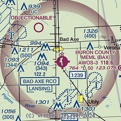
| Sectional chart |
|---|
|
| Airport distance calculator |
|---|
|
|
| Sunrise and sunset |
|---|
|
Times for 23-Nov-2025
| | Local
(UTC-5) | | Zulu
(UTC) |
|---|
| Morning civil twilight | | 07:06 | | 12:06 |
| Sunrise | | 07:38 | | 12:38 |
| Sunset | | 16:59 | | 21:59 |
| Evening civil twilight | | 17:31 | | 22:31 |
|
| Current date and time |
|---|
| Zulu (UTC) | 23-Nov-2025 13:56:43 |
|---|
| Local (UTC-5) | 23-Nov-2025 08:56:43 |
|---|
|
| METAR |
|---|
| KBAX | 231335Z AUTO 28008KT 10SM CLR 04/02 A2991 RMK AO2 T00400015
|
KP58
16nm NE | 231255Z AUTO 25009G16KT 04/02 A2985 RMK AO1 SLP117 T00440017 $
|
|
| TAF |
|---|
KMBS
50nm W | 231120Z 2312/2412 26009KT P6SM SCT040 FM231500 28015G25KT P6SM SKC FM232200 28008KT P6SM BKN150 FM240500 23004KT P6SM SCT250
|
|
| NOTAMs |
|---|
NOTAMs are issued by the DoD/FAA and will open in a separate window not controlled by AirNav.
|
|


