FAA INFORMATION EFFECTIVE 27 NOVEMBER 2025
Location
| FAA Identifier: | 6D9 |
| Lat/Long: | 44-18-46.2000N 083-25-20.3000W
44-18.770000N 083-25.338333W
44.3128333,-83.4223056
(estimated) |
| Elevation: | 605.3 ft. / 184.5 m (surveyed) |
| Variation: | 08W (2015) |
| From city: | 3 miles NE of EAST TAWAS, MI |
| Time zone: | UTC -5 (UTC -4 during Daylight Saving Time) |
| Zip code: | 48730 |
Airport Operations
| Airport use: | Open to the public |
| Activation date: | 08/1962 |
| Control tower: | no |
| ARTCC: | MINNEAPOLIS CENTER |
| FSS: | LANSING FLIGHT SERVICE STATION |
| NOTAMs facility: | LAN (NOTAM-D service available) |
| Attendance: | SUN ON CALL, ALL MON-FRI IREG
FOR SVC CALL AMGR. |
| Wind indicator: | lighted |
| Segmented circle: | yes |
| Lights: | ACTVT REIL RWY 08 & 26; PAPI RWY 08 & 26; MIRL RWY 08/26 - 122.85. |
| Beacon: | white-green (lighted land airport)
Operates sunset to sunrise. |
Airport Communications
| CTAF/UNICOM: | 122.8 |
| WX AWOS-3P at OSC (8 nm N): | 118.7 (989-739-1310) |
- APCH/DEP SVC PRVDD BY MINNEAPOLIS ARTCC ON FREQS 125.475/269.45 (OSCODA RCAG).
Airport Services
| Fuel available: | 100LL |
| Parking: | tiedowns |
| Airframe service: | NONE |
| Powerplant service: | NONE |
| Bottled oxygen: | NONE |
| Bulk oxygen: | NONE |
Runway Information
Runway 8/26
| Dimensions: | 4802 x 75 ft. / 1464 x 23 m |
| Surface: | asphalt, in good condition |
| Weight bearing capacity: | |
| Runway edge lights: | medium intensity |
| RUNWAY 8 | | RUNWAY 26 |
| Latitude: | 44-18.688593N | | 44-18.851967N |
| Longitude: | 083-25.876248W | | 083-24.799382W |
| Elevation: | 605.3 ft. | | 604.2 ft. |
| Traffic pattern: | left | | left |
| Runway heading: | 086 magnetic, 078 true | | 266 magnetic, 258 true |
| Markings: | nonprecision, in good condition | | nonprecision, in good condition |
| Visual slope indicator: | 2-light PAPI on left (3.00 degrees glide path) | | 2-light PAPI on left (3.00 degrees glide path) |
| Runway end identifier lights: | yes | | yes |
| Touchdown point: | yes, no lights | | yes, no lights |
| Obstructions: | 12 ft. tree, 421 ft. from runway, 270 ft. right of centerline, 18:1 slope to clear | | 34 ft. tree, 363 ft. from runway, 278 ft. right of centerline, 4:1 slope to clear |
Airport Ownership and Management from official FAA records
| Ownership: | Publicly-owned |
| Owner: | IOSCO COUNTY
422 LAKE ST
TAWAS CITY, MI 48763
Phone 989-362-5832 |
| Manager: | JAY SAMUELS
1131 AULERICH RD
EAST TAWAS, MI 48730-9565
Phone 989-305-0126 |
Additional Remarks
| - | DEER & LRG BIRDS ON & INVOF ARPT. |
| - | FOR CD CTC MINNEAPOLIS ARTCC AT 651-463-5588. |
Instrument Procedures
NOTE: All procedures below are presented as PDF files. If you need a reader for these files, you should download the free Adobe Reader.NOT FOR NAVIGATION. Please procure official charts for flight.
FAA instrument procedures published for use from 27 November 2025 at 0901Z to 25 December 2025 at 0900Z.
IAPs - Instrument Approach Procedures |
|---|
| RNAV (GPS) RWY 08 | |
download (208KB) |
| NOTE: Special Take-Off Minimums/Departure Procedures apply | |
download (122KB) |
Other nearby airports with instrument procedures:
KOSC - Oscoda/Wurtsmith Airport (8 nm N)
Y31 - West Branch Community Airport (33 nm W)
KBAX - Huron County Memorial Airport (37 nm SE)
KAPN - Alpena County Regional Airport (46 nm N)
KGDW - Gladwin Zettel Memorial Airport (50 nm SW)
|
|

Road maps at:
MapQuest
Bing
Google
| Aerial photo |
|---|
WARNING: Photo may not be current or correct
 Photographer = Nick Ortenburger
Pilot = Travis Worthington
Do you have a better or more recent aerial photo of Iosco County Airport that you would like to share? If so, please send us your photo.
|
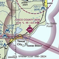
| Sectional chart |
|---|
|
| Airport distance calculator |
|---|
|
|
| Sunrise and sunset |
|---|
|
Times for 15-Dec-2025
| | Local
(UTC-5) | | Zulu
(UTC) |
|---|
| Morning civil twilight | | 07:30 | | 12:30 |
| Sunrise | | 08:04 | | 13:04 |
| Sunset | | 16:54 | | 21:54 |
| Evening civil twilight | | 17:27 | | 22:27 |
|
| Current date and time |
|---|
| Zulu (UTC) | 15-Dec-2025 07:01:21 |
|---|
| Local (UTC-5) | 15-Dec-2025 02:01:21 |
|---|
|
| TAF |
|---|
KAPN
46nm N | 150520Z 1506/1606 24005KT P6SM VCSH OVC035 FM151200 21008G19KT 4SM -SHSN OVC028 TEMPO 1512/1516 1 1/2SM -SN BKN015 FM151700 25011G20KT P6SM VCSH OVC030 FM152200 26007KT P6SM BKN026 FM160300 26004KT P6SM BKN035
|
|
| NOTAMs |
|---|
NOTAMs are issued by the DoD/FAA and will open in a separate window not controlled by AirNav.
|
|

