FAA INFORMATION EFFECTIVE 09 JULY 2026
Location
| FAA Identifier: | APN |
| Lat/Long: | 45-04-41.1000N 083-33-37.1000W
45-04.685000N 083-33.618333W
45.0780833,-83.5603056
(estimated) |
| Elevation: | 689.5 ft. / 210.2 m (surveyed) |
| Variation: | 07W (1985) |
| From city: | 6 miles W of ALPENA, MI |
| Time zone: | UTC -4 (UTC -5 during Standard Time) |
| Zip code: | 49707 |
Airport Operations
| Airport use: | Open to the public |
| Activation date: | 04/1940 |
| Control tower: | yes |
| ARTCC: | MINNEAPOLIS CENTER |
| FSS: | LANSING FLIGHT SERVICE STATION |
| NOTAMs facility: | APN (NOTAM-D service available) |
| Attendance: | 0500-2300
FOR SER AFT HRS CALL 989-464-1419/989-255-4871. |
| Wind indicator: | lighted |
| Segmented circle: | yes |
| Lights: | ACTVT MALSR RWY 01; REIL RWY 19, 07, & 25; HIRL RWY 01/19; MIRL RWY 07/25 - CTAF. |
| Beacon: | white-green (lighted land airport)
Operates sunset to sunrise. |
| Landing fee: | yes |
| Fire and rescue: | ARFF index A |
Airport Communications
| CTAF: | 121.35 |
| UNICOM: | 122.95 |
| ATIS: | 120.675 327.05 |
| WX ASOS: | 120.675 (989-200-3256) |
| ALPENA GROUND: | 121.9 275.8 [0800-1600 WKDAYS; EXCP HOLS (ANG).] |
| ALPENA TOWER: | 121.35 318.1 [0800-1600 WKDAYS; EXCP HOLS (ANG).] |
| ALPENA APPROACH: | 128.425 379.3 [0800-1600 WKDAYS (ANG).] |
| ALPENA DEPARTURE: | 128.425 379.3 [0800-1600 WKDAYS (ANG).] |
| EMERG: | 121.5 243.0 |
| PTD: | 348.4 |
- APCH/DEP SVC PRVDD BY MINNEAPOLIS ARTCC ON FREQS 125.475/269.45 (ALPENA RCAG) WHEN ALPENA APCH CTL CLSD.
- OPR 1300-2100Z++. 348.4
Nearby radio navigation aids
| VOR radial/distance | | VOR name | | Freq | | Var |
|---|
| APN at field | | ALPENA VORTAC | | 116.50 | | 07W |
| NDB name | | Hdg/Dist | | Freq | | Var | | ID |
|---|
| FELPS | | 007/7.0 | | 206 | | 07W | | AP | .- .--. |
Airport Services
| Fuel available: | 100LL JET-A |
| Parking: | hangars and tiedowns |
| Airframe service: | MINOR |
| Powerplant service: | MINOR |
| Bottled oxygen: | NONE |
| Bulk oxygen: | NONE |
Runway Information
Runway 1/19
| Dimensions: | 9001 x 150 ft. / 2744 x 46 m |
| Surface: | concrete/grooved, in good condition |
| Weight bearing capacity: | | Single wheel: | 95.0 | | Double wheel: | 115.0 | | Double tandem: | 170.0 | | Dual double tandem: | 468.0, TRT 560. |
|
| Runway edge lights: | high intensity |
| RUNWAY 1 | | RUNWAY 19 |
| Latitude: | 45-03.896465N | | 45-05.377600N |
| Longitude: | 083-33.682090W | | 083-33.689405W |
| Elevation: | 682.9 ft. | | 683.0 ft. |
| Traffic pattern: | left | | left |
| Runway heading: | 007 magnetic, 360 true | | 187 magnetic, 180 true |
| Declared distances: | TORA:9001 TODA:9001 ASDA:9001 LDA:9001 | | TORA:9001 TODA:9001 ASDA:9001 LDA:9001 |
| Markings: | precision, in good condition | | precision, in good condition |
| Visual slope indicator: | 4-light PAPI on left (3.00 degrees glide path) | | 4-light PAPI on left (3.00 degrees glide path) |
| Approach lights: | MALSR: 1,400 foot medium intensity approach lighting system with runway alignment indicator lights | | |
| Runway end identifier lights: | no | | yes |
| Touchdown point: | yes, no lights | | yes, no lights |
| Instrument approach: | ILS | | |
| Obstructions: | 68 ft. tree, 3190 ft. from runway, 329 ft. right of centerline, 43:1 slope to clear | | 56 ft. tree, 2174 ft. from runway, 440 ft. right of centerline, 35:1 slope to clear |
Runway 7/25
| Dimensions: | 5028 x 100 ft. / 1533 x 30 m |
| Surface: | concrete/grooved, in fair condition |
| Weight bearing capacity: | | PCN 4 /R/B/Z/U | | Single wheel: | 93.0 | | Double wheel: | 111.0 | | Double tandem: | 170.0 | | Dual double tandem: | 438.0, TRT 560. |
|
| Runway edge lights: | medium intensity |
| Operational restrictions: | RWY 07/25 NOT AVBL FOR PART 121/PART 380 OPS WITH SKED PAX CARRYING OPS MORE THAN 9 PAX SEATS AND NON-SKED PAX CARRYING OPS MORE THAN 30 PAX SEATS. |
| RUNWAY 7 | | RUNWAY 25 |
| Latitude: | 45-04.562293N | | 45-04.978400N |
| Longitude: | 083-34.001918W | | 083-32.992560W |
| Elevation: | 689.5 ft. | | 679.6 ft. |
| Traffic pattern: | left | | left |
| Runway heading: | 067 magnetic, 060 true | | 247 magnetic, 240 true |
| Declared distances: | TORA:5028 TODA:5028 ASDA:5028 LDA:5028 | | TORA:5028 TODA:5028 ASDA:5028 LDA:5028 |
| Markings: | nonprecision, in good condition | | nonprecision, in good condition |
| Visual slope indicator: | 4-light PAPI on left (3.00 degrees glide path) | | 4-light PAPI on left (3.00 degrees glide path) |
| Runway end identifier lights: | yes | | yes |
| Touchdown point: | yes, no lights | | yes, no lights |
| Obstructions: | 46 ft. trees, 1200 ft. from runway, 21:1 slope to clear | | 80 ft. trees, 2866 ft. from runway, 427 ft. left of centerline, 33:1 slope to clear |
Airport Ownership and Management from official FAA records
| Ownership: | Publicly-owned |
| Owner: | COUNTY OF ALPENA
1617 AIRPORT RD
ALPENA, MI 49707-8213
Phone 989-354-2907 |
| Manager: | MR. EDWARD HIGGINS
1617 AIRPORT RD
ALPENA, MI 49707-8213
Phone 989-354-2907 |
Additional Remarks
| A39-01/19 | PCR VALUE: 480/F/C/X/T |
| E60-01 | BAK-14 BAK-12A(B) (1500 FT). |
| E60-19 | BAK-14 BAK-12A(B) (1515 FT). |
| - | RWY 01 & 19 EACH HAVE 1000 FT OVRN. |
| - | TWY A WEST OF TWY C & TWY B RSTRD TO MIL ONLY. BE ALERT FOR UNCONTROLLED VEHICLES ON THE TWY. |
| - | TWY H EAST OF RWY 01/19 UNLGTD. |
| - | MILITARY: ANG: JOAP SER UNAVBL. |
| - | FOR CD IF UNA TO CTC ON FSS FREQ, CTC MINNEAPOLIS ARTCC AT 651-463-5588. |
| - | BIRDS & OTR WILDLIFE ON & INVOF ARPT. |
| - | MILITARY: SER: FUEL A++. |
| - | MILITARY: ANG: DUTY HRS 0800-1600 MON-FRI EXC HOLS. |
Instrument Procedures
NOTE: All procedures below are presented as PDF files. If you need a reader for these files, you should download the free Adobe Reader.NOT FOR NAVIGATION. Please procure official charts for flight.
FAA instrument procedures published for use from 09 July 2026 at 0901Z to 06 August 2026 at 0900Z.
IAPs - Instrument Approach Procedures |
|---|
| HI-ILS OR LOC RWY 01 | |
download (170KB) |
| ILS OR LOC RWY 01 | |
download (238KB) |
| RNAV (GPS) RWY 01 | |
download (301KB) |
| RNAV (GPS) RWY 07 | |
download (250KB) |
| RNAV (GPS) RWY 07 | |
download (250KB) |
| RNAV (GPS) RWY 19 | |
download (229KB) |
| RNAV (GPS) RWY 25 | |
download (250KB) |
| RNAV (GPS) RWY 25 | |
download (250KB) |
| HI-VOR OR TACAN RWY 01 | |
download (207KB) |
| VOR RWY 19 | |
download (203KB) |
| HI-TACAN RWY 19 | |
download (155KB) |
| NOTE: Special Alternate Minimums apply | |
download (139KB) |
| NOTE: Special Take-Off Minimums/Departure Procedures apply | |
download (371KB) |
Other nearby airports with instrument procedures:
KPZQ - Presque Isle County Airport (22 nm NW)
KOSC - Oscoda/Wurtsmith Airport (38 nm S)
6D9 - Iosco County Airport (46 nm S)
KGLR - Gaylord Regional Airport (49 nm W)
KSLH - Cheboygan County Airport (53 nm NW)
|
|

Road maps at:
MapQuest
Bing
Google
| Aerial photo |
|---|
WARNING: Photo may not be current or correct

Do you have a better or more recent aerial photo of Alpena County Regional Airport that you would like to share? If so, please send us your photo.
|
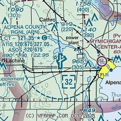
| Sectional chart |
|---|
|
| Airport distance calculator |
|---|
|
|
| Sunrise and sunset |
|---|
|
Times for 18-Jul-2026
| | Local
(UTC-4) | | Zulu
(UTC) |
|---|
| Morning civil twilight | | 05:30 | | 09:30 |
| Sunrise | | 06:05 | | 10:05 |
| Sunset | | 21:15 | | 01:15 |
| Evening civil twilight | | 21:51 | | 01:51 |
|
| Current date and time |
|---|
| Zulu (UTC) | 18-Jul-2026 20:04:59 |
|---|
| Local (UTC-4) | 18-Jul-2026 16:04:59 |
|---|
|
| METAR |
|---|
| KAPN | 181954Z AUTO 32015G23KT 4SM HZ FU OVC020 21/16 A2981 RMK AO2 PK WND 33027/1944 SLP092 T02060161
|
|
| TAF |
|---|
| KAPN | 181720Z 1818/1918 30010G24KT 2SM FU SCT015 BKN020 TEMPO 1818/1822 BKN015 FM190100 34005KT 4SM FU SKC FM191300 VRB03KT 4SM FU SCT030
|
|
| NOTAMs |
|---|
NOTAMs are issued by the DoD/FAA and will open in a separate window not controlled by AirNav.
|
|

