FAA INFORMATION EFFECTIVE 30 OCTOBER 2025
Location
| FAA Identifier: | SLH |
| Lat/Long: | 45-39-13.4560N 084-31-09.4720W
45-39.224267N 084-31.157867W
45.6537378,-84.5192978
(estimated) |
| Elevation: | 639.7 ft. / 195.0 m (surveyed) |
| Variation: | 07W (2005) |
| From city: | 2 miles W of CHEBOYGAN, MI |
| Time zone: | UTC -5 (UTC -4 during Daylight Saving Time) |
| Zip code: | 49721 |
Airport Operations
| Airport use: | Open to the public |
| Activation date: | 07/1971 |
| Control tower: | no |
| ARTCC: | MINNEAPOLIS CENTER |
| FSS: | LANSING FLIGHT SERVICE STATION |
| NOTAMs facility: | SLH (NOTAM-D service available) |
| Attendance: | 0800-1600
UNATNDD CHRISTMAS, EASTER, & THANKSGIVING. |
| Wind indicator: | lighted |
| Segmented circle: | yes |
| Lights: | ACTVT REIL RWY 10 & 28; PAPI RWY 10 & 28; MIRL RWY 10/28 & 17/35 - 122.5. |
| Beacon: | white-green (lighted land airport)
Operates sunset to sunrise. |
Airport Communications
| CTAF/UNICOM: | 122.8 |
| WX AWOS-3: | 118.175 (231-627-4671) |
| WX ASOS at PLN (13 nm SW): | 119.025 (231-539-7700) |
| WX AWOS-3 at MCD (14 nm N): | 118.275 (906-847-3778) |
- APCH/DEP SVC PRVDD BY MINNEAPOLIS ARTCC ON FREQS 134.6/354.05 (PELLSTON RCAG).
Nearby radio navigation aids
| VOR radial/distance | | VOR name | | Freq | | Var |
|---|
| PLNr083/6.2 | | PELLSTON VORTAC | | 111.80 | | 06W |
Airport Services
| Fuel available: | 100LL JET-A+
100LL:100LL AVBL H24 SELF SVC; FOR JET A+ AFT HRS CALL 989-464-6887 OR 616-443-1010 SUBJ CALL-IN FEE. |
| Airframe service: | MAJOR |
| Powerplant service: | MAJOR |
Runway Information
Runway 10/28
| Dimensions: | 4004 x 75 ft. / 1220 x 23 m |
| Surface: | asphalt, in good condition |
| Weight bearing capacity: | | Single wheel: | 23.0 | | Double wheel: | 34.0 | | Double tandem: | 60.0 |
|
| Runway edge lights: | medium intensity |
| RUNWAY 10 | | RUNWAY 28 |
| Latitude: | 45-39.251433N | | 45-39.252565N |
| Longitude: | 084-31.634998W | | 084-30.695462W |
| Elevation: | 639.5 ft. | | 626.9 ft. |
| Traffic pattern: | left | | left |
| Runway heading: | 097 magnetic, 090 true | | 277 magnetic, 270 true |
| Markings: | nonprecision, in good condition | | nonprecision, in good condition |
| Visual slope indicator: | 2-light PAPI on left (4.00 degrees glide path) | | 2-light PAPI on left (4.00 degrees glide path) |
| Runway end identifier lights: | yes | | yes |
| Touchdown point: | yes, no lights | | yes, no lights |
| Obstructions: | 19 ft. road, 380 ft. from runway, 276 ft. left and right of centerline, 9:1 slope to clear | | 33 ft. trees, 376 ft. from runway, 250 ft. left of centerline, 5:1 slope to clear |
Runway 17/35
| Dimensions: | 1874 x 60 ft. / 571 x 18 m |
| Surface: | asphalt, in good condition |
| Runway edge lights: | medium intensity |
| RUNWAY 17 | | RUNWAY 35 |
| Latitude: | 45-39.313920N | | 45-39.015997N |
| Longitude: | 084-31.198910W | | 084-31.085332W |
| Elevation: | 633.0 ft. | | 635.5 ft. |
| Traffic pattern: | left | | left |
| Runway heading: | 172 magnetic, 165 true | | 352 magnetic, 345 true |
| Markings: | basic, in good condition | | basic, in good condition |
| Touchdown point: | yes, no lights | | yes, no lights |
| Obstructions: | none | | 83 ft. trees, 1427 ft. from runway, 248 ft. left of centerline, 14:1 slope to clear |
Airport Ownership and Management from official FAA records
| Ownership: | Publicly-owned |
| Owner: | CHEBOYGAN AIRPORT AUTHORITY
1520 LEVERING RD
CHEBOYGAN, MI 49721-9381
Phone 231-627-5571 |
| Manager: | MICHAEL JERMEAY
1520 LEVERING RD
CHEBOYGAN, MI 49721-9381
Phone 231-627-5571 |
Additional Remarks
| - | DEER & BIRDS ON & INVOF ARPT. |
| - | AFT HRS TRML BLDG ACES: PRESS 5, THEN 3 & 2 SIMUL, THEN 1. |
| - | FOR CD CTC MINNEAPOLIS ARTCC AT 651-463-5588. |
Instrument Procedures
NOTE: All procedures below are presented as PDF files. If you need a reader for these files, you should download the free Adobe Reader.NOT FOR NAVIGATION. Please procure official charts for flight.
FAA instrument procedures published for use from 30 October 2025 at 0901Z to 27 November 2025 at 0900Z.
IAPs - Instrument Approach Procedures |
|---|
| RNAV (GPS) RWY 10 | |
download (220KB) |
| RNAV (GPS) RWY 28 | |
download (262KB) |
| VOR RWY 10 | |
download (276KB) |
| NOTE: Special Alternate Minimums apply | |
download (26KB) |
| NOTE: Special Take-Off Minimums/Departure Procedures apply | |
download (255KB) |
Other nearby airports with instrument procedures:
6Y1 - Bois Blanc Island Airport (7 nm N)
KPLN - Pellston Regional/Emmet County Airport (13 nm SW)
KMCD - Mackinac Island Airport (14 nm N)
83D - Mackinac County Airport (17 nm NW)
KMGN - Harbor Springs Airport (21 nm SW)
|
|

Road maps at:
MapQuest
Bing
Google
| Aerial photo |
|---|
WARNING: Photo may not be current or correct
 Photo taken 02-Jul-2007
Do you have a better or more recent aerial photo of Cheboygan County Airport that you would like to share? If so, please send us your photo.
|
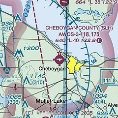
| Sectional chart |
|---|
|
| Airport distance calculator |
|---|
|
|
| Sunrise and sunset |
|---|
|
Times for 11-Nov-2025
| | Local
(UTC-5) | | Zulu
(UTC) |
|---|
| Morning civil twilight | | 07:01 | | 12:01 |
| Sunrise | | 07:33 | | 12:33 |
| Sunset | | 17:11 | | 22:11 |
| Evening civil twilight | | 17:43 | | 22:43 |
|
| Current date and time |
|---|
| Zulu (UTC) | 11-Nov-2025 13:54:13 |
|---|
| Local (UTC-5) | 11-Nov-2025 08:54:13 |
|---|
|
| METAR |
|---|
| KSLH | 111335Z AUTO 21004KT 10SM OVC030 00/M04 A2983 RMK AO2
|
KMCD
13nm N | 111335Z AUTO 29004KT 10SM OVC027 00/M04 A2981 RMK AO2
|
KPLN
13nm SW | 111254Z AUTO 24003KT 10SM OVC032 00/M04 A2985 RMK AO2 SLP118 T00001044
|
|
| TAF |
|---|
KPLN
13nm SW | 111122Z 1112/1212 27005KT P6SM BKN029 FM111500 21010G19KT P6SM OVC045 FM111800 21011G21KT P6SM VCSH OVC029 FM120000 22010G21KT 3SM -SHSN BR OVC013 FM120500 27007KT 6SM -SHRA BR OVC023 FM121000 28010G22KT 6SM -SHRA BR OVC013
|
|
| NOTAMs |
|---|
NOTAMs are issued by the DoD/FAA and will open in a separate window not controlled by AirNav.
|
|

