FAA INFORMATION EFFECTIVE 19 MARCH 2026
Location
| FAA Identifier: | C04 |
| Lat/Long: | 43-38-29.8800N 086-19-44.6380W
43-38.498000N 086-19.743967W
43.6416333,-86.3290661
(estimated) |
| Elevation: | 915.8 ft. / 279.1 m (surveyed) |
| Variation: | 05W (2015) |
| From city: | 4 miles SE of central business district of the associated city |
| Time zone: | UTC -4 (UTC -5 during Standard Time) |
| Zip code: | 49455 |
Airport Operations
| Airport use: | Open to the public |
| Activation date: | 11/1950 |
| Control tower: | no |
| ARTCC: | CHICAGO CENTER |
| FSS: | LANSING FLIGHT SERVICE STATION |
| NOTAMs facility: | LAN (NOTAM-D service available) |
| Attendance: | IREG |
| Wind indicator: | lighted |
| Segmented circle: | yes |
| Lights: | ACTVT PAPI RWY 09 & 27; MIRL RWY 09/27 - CTAF. |
Airport Communications
| CTAF/UNICOM: | 122.7 |
| WX AWOS-AV: | 122.7 (231-861-7415) |
| GREAT LAKES APPROACH: | 119.8 |
| GREAT LAKES DEPARTURE: | 119.8 |
| WX AWOS-3P at FFX (19 nm SE): | 118.775 (231-928-0715) |
| WX AWOS-3P at LDM (20 nm N): | 119.925 (231-843-0459) |
- APCH/DEP SVC PRVDD BY CHICAGO ARTCC ON FREQS 125.1/290.475 (MILWAUKEE RCAG) WHEN GREAT LAKES APCH CTL CLSD.
Airport Services
| Fuel available: | 100LL
100LL:AVBL H24 SELF SVC. |
| Parking: | tiedowns |
| Airframe service: | NONE
RPRS ON CALL 231-861-2210 OR 231-730-6644. |
| Powerplant service: | NONE |
| Bottled oxygen: | NONE |
| Bulk oxygen: | NONE |
Runway Information
Runway 9/27
| Dimensions: | 3500 x 75 ft. / 1067 x 23 m |
| Surface: | asphalt, in good condition |
| Weight bearing capacity: | |
| Runway edge lights: | medium intensity |
| RUNWAY 9 | | RUNWAY 27 |
| Latitude: | 43-38.457545N | | 43-38.531418N |
| Longitude: | 086-20.163285W | | 086-19.376657W |
| Elevation: | 915.8 ft. | | 901.9 ft. |
| Traffic pattern: | left | | left |
| Runway heading: | 088 magnetic, 083 true | | 268 magnetic, 263 true |
| Markings: | nonprecision, in good condition | | nonprecision, in good condition |
| Visual slope indicator: | 2-light PAPI on left (4.00 degrees glide path) | | 2-light PAPI on left (4.00 degrees glide path) |
| Runway end identifier lights: | no | | no |
| Touchdown point: | yes, no lights | | yes, no lights |
| Obstructions: | 156 ft. trees, 2952 ft. from runway, 605 ft. right of centerline, 17:1 slope to clear | | 88 ft. trees, marked and lighted, 1865 ft. from runway, 496 ft. left of centerline, 18:1 slope to clear |
Runway 15/33
| Dimensions: | 2251 x 100 ft. / 686 x 30 m |
| Surface: | turf, in good condition
ROUGH & SOFT WHEN WET. |
| Runway edge markings: | RWY & DTHR MKD WITH 3 FT YELLOW CONES. |
| RUNWAY 15 | | RUNWAY 33 |
| Latitude: | 43-38.651447N | | 43-38.355492N |
| Longitude: | 086-19.856808W | | 086-19.550200W |
| Elevation: | 897.3 ft. | | 888.2 ft. |
| Traffic pattern: | left | | left |
| Runway heading: | 148 magnetic, 143 true | | 328 magnetic, 323 true |
| Displaced threshold: | 369 ft. | | 557 ft. |
| Runway end identifier lights: | no | | no |
| Touchdown point: | yes, no lights | | yes, no lights |
| Obstructions: | 2 ft. road, 100 ft. left of centerline
CTLG OBSTN EXCEEDS A 45 DEG SLP. APCH RATIO 20:1 TO DTHR. | | 5 ft. trees, 5 ft. from runway, 100 ft. left of centerline, 1:1 slope to clear
APCH RATIO 11:1 TO DTHR OVR +99 FT TREE, 1145 FT DIST, 200 FT R. |
Airport Ownership and Management from official FAA records
| Ownership: | Publicly-owned |
| Owner: | OCEANA COUNTY COURT HOUSE
100 S STATE ST, PO BOX 14
HART, MI 49420-1188
Phone 231-873-4835 |
| Manager: | CURT LOHMAN
1805 BASELINE RD
SHELBY, MI 49455-9630
Phone 231-861-9910
CELL 231-742-0142. |
Additional Remarks
| - | RDO CTL ACFT OPS AT RWY 15 END. |
| - | FOR FICONS CALL 231-861-4272 (AMGR RES) OR 231-742-0142 (CELL). |
| - | ADMIN BLDG ACES: PRESS V, THEN III & II SIMUL, THEN I. |
| - | FOR CD CTC GREAT LAKES APCH AT 269-459-3344, WHEN APCH CLSD CTC CHICAGO ARTCC AT 630-906-8921. |
Instrument Procedures
NOTE: All procedures below are presented as PDF files. If you need a reader for these files, you should download the free Adobe Reader.NOT FOR NAVIGATION. Please procure official charts for flight.
FAA instrument procedures published for use from 19 March 2026 at 0901Z to 16 April 2026 at 0900Z.
IAPs - Instrument Approach Procedures |
|---|
| RNAV (GPS) RWY 09 | |
download (200KB) |
| RNAV (GPS) RWY 27 | |
download (232KB) |
| NOTE: Special Take-Off Minimums/Departure Procedures apply | |
download (381KB) |
Other nearby airports with instrument procedures:
KFFX - Fremont Municipal Airport (19 nm SE)
KLDM - Mason County Airport (20 nm N)
7D3 - Baldwin Municipal Airport (25 nm NE)
KMKG - Muskegon County Airport (29 nm S)
KRQB - Roben-Hood Airport (36 nm E)
|
|

Road maps at:
MapQuest
Bing
Google
| Aerial photo |
|---|
WARNING: Photo may not be current or correct

Do you have a better or more recent aerial photo of Oceana County Airport that you would like to share? If so, please send us your photo.
|
| Sectional chart |
|---|
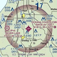
|
| Airport distance calculator |
|---|
|
|
| Sunrise and sunset |
|---|
|
Times for 03-Apr-2026
| | Local
(UTC-4) | | Zulu
(UTC) |
|---|
| Morning civil twilight | | 06:55 | | 10:55 |
| Sunrise | | 07:24 | | 11:24 |
| Sunset | | 20:13 | | 00:13 |
| Evening civil twilight | | 20:42 | | 00:42 |
|
| Current date and time |
|---|
| Zulu (UTC) | 03-Apr-2026 16:32:02 |
|---|
| Local (UTC-4) | 03-Apr-2026 12:32:02 |
|---|
|
| METAR |
|---|
KFFX
19nm SE | 031615Z AUTO 28009KT 10SM OVC014 06/02 A3007 RMK AO2
|
KLDM
20nm N | 031615Z AUTO 29010G16KT 10SM OVC017 04/01 A3008 RMK AO2
|
KMKG
29nm S | 031555Z 31010KT 10SM OVC019 07/02 A3007 RMK AO2 SLP186 T00670022
|
KRQB
36nm E | 031615Z AUTO 30011KT 7SM BR OVC007 03/02 A3004 RMK AO2
|
KMBL
38nm N | 031556Z AUTO 28013KT 10SM OVC018 04/01 A3006 RMK AO2 SLP181 T00440011 $
|
|
| TAF |
|---|
KMKG
29nm S | 031120Z 0312/0412 27014G24KT P6SM OVC015 FM031600 28010KT P6SM BKN025 FM032200 34006KT P6SM BKN250 FM040400 08012G22KT P6SM VCSH OVC045 FM040600 09013G24KT P6SM -SHRA OVC025 FM041000 11015G25KT 4SM -SHRA BR OVC008
|
|
| NOTAMs |
|---|
NOTAMs are issued by the DoD/FAA and will open in a separate window not controlled by AirNav.
|
|

