FAA INFORMATION EFFECTIVE 15 MAY 2025
Location
| FAA Identifier: | C73 |
| Lat/Long: | 41-50-01.3160N 089-26-46.3680W
41-50.021933N 089-26.772800W
41.8336989,-89.4462133
(estimated) |
| Elevation: | 785 ft. / 239.3 m (surveyed) |
| Variation: | 02W (2010) |
| From city: | 1 mile E of DIXON, IL |
| Time zone: | UTC -5 (UTC -6 during Standard Time) |
| Zip code: | 61021 |
Airport Operations
| Airport use: | Open to the public |
| Activation date: | 04/1940 |
| Control tower: | no |
| ARTCC: | CHICAGO CENTER |
| FSS: | KANKAKEE FLIGHT SERVICE STATION |
| NOTAMs facility: | IKK (NOTAM-D service available) |
| Attendance: | MON-FRI 0800-1700, ALL SAT 0800-1200, ALL SUN ON CALL
FOR ATTENDANT CALL 815-667-0161 OR 815-440-6557. ADM BLDG ACCESS IS 24 HRS FOR RESTROOM. |
| Wind indicator: | lighted |
| Segmented circle: | yes |
| Lights: | MIRL RY 12/30 PRESET ON LOW INTST SS-SR; TO INCR INTST & ACTVT MIRL RY 08/26, REIL RY 08, PAPI RY 26 - CTAF. |
| Beacon: | white-green (lighted land airport)
Operates sunset to sunrise. |
Airport Communications
| CTAF/UNICOM: | 123.05 |
| WX AWOS-AV: | 118.575 (815-288-2039) |
| ROCKFORD APPROACH: | 126.0 |
| ROCKFORD DEPARTURE: | 126.0 |
| WX AWOS-3PT at SQI (12 nm SW): | 119.175 (815-626-2704) |
| WX AWOS-3 at RPJ (17 nm E): | 125.2 (815-562-2955) |
Airport Services
| Fuel available: | 100LL
100LL:SELF FUELING AVBL 24 HRS. |
| Parking: | hangars and tiedowns |
| Airframe service: | MAJOR |
| Powerplant service: | MAJOR |
| Bottled oxygen: | NONE |
| Bulk oxygen: | NONE |
Runway Information
Runway 8/26
| Dimensions: | 3897 x 75 ft. / 1188 x 23 m |
| Surface: | asphalt, in good condition |
| Weight bearing capacity: | |
| Runway edge lights: | medium intensity |
| RUNWAY 8 | | RUNWAY 26 |
| Latitude: | 41-49.947333N | | 41-50.060167N |
| Longitude: | 089-27.268667W | | 089-26.424017W |
| Elevation: | 781.5 ft. | | 784.3 ft. |
| Traffic pattern: | left | | left |
| Runway heading: | 082 magnetic, 080 true | | 262 magnetic, 260 true |
| Markings: | nonprecision, in good condition | | nonprecision, in good condition |
| Visual slope indicator: | | | 4-light PAPI on left (3.00 degrees glide path) |
| Runway end identifier lights: | yes | | |
| Touchdown point: | yes, no lights | | yes, no lights |
Runway 12/30
| Dimensions: | 2803 x 75 ft. / 854 x 23 m |
| Surface: | asphalt, in excellent condition |
| Weight bearing capacity: | |
| Runway edge lights: | medium intensity |
| RUNWAY 12 | | RUNWAY 30 |
| Latitude: | 41-50.167317N | | 41-49.927150N |
| Longitude: | 089-26.935550W | | 089-26.408683W |
| Elevation: | 777.0 ft. | | 785.0 ft. |
| Traffic pattern: | left | | left |
| Runway heading: | 123 magnetic, 121 true | | 303 magnetic, 301 true |
| Markings: | basic, in good condition | | basic, in good condition |
| Runway end identifier lights: | no | | no |
| Touchdown point: | yes, no lights | | yes, no lights |
Airport Ownership and Management from official FAA records
| Ownership: | Publicly-owned |
| Owner: | CITY OF DIXON
1650 FRANKLIN GROVE ROAD
DIXON, IL 61021
Phone 815-288-1485 |
| Manager: | TYLER VENIER
1650 FRANKLIN GROVE RD
DIXON, IL 61021
Phone 815-973-4200
815-440-6186 MANAGER CELL NUMBER |
Additional Remarks
| - | HELIPAD PARKING DESIGNATION LOCATED AT NE CORNER OF RAMP/APRON AREA. |
| - | FOR CD CTC CHICAGO ARTCC AT 630-906-8921. |
Instrument Procedures
NOTE: All procedures below are presented as PDF files. If you need a reader for these files, you should download the free Adobe Reader.NOT FOR NAVIGATION. Please procure official charts for flight.
FAA instrument procedures published for use from 15 May 2025 at 0901Z to 13 June 2025 at 0900z.
IAPs - Instrument Approach Procedures |
|---|
| RNAV (GPS) RWY 08 | |
download (232KB) |
| RNAV (GPS) RWY 26 | |
download (248KB) |
| NOTE: Special Take-Off Minimums/Departure Procedures apply | |
download (478KB) |
Other nearby airports with instrument procedures:
KSQI - Whiteside County Airport/Jos H Bittorf Field (12 nm SW)
KRPJ - Rochelle Municipal Airport/Koritz Field (17 nm E)
KFEP - Albertus Airport (25 nm N)
KRFD - Chicago/Rockford International Airport (27 nm NE)
KVYS - Illinois Valley Regional Airport-Walter A Duncan Field (32 nm SE)
|
|

Road maps at:
MapQuest
Bing
Google
| Aerial photo |
|---|
WARNING: Photo may not be current or correct
 Photo courtesy of AirNav, LLC
Photo taken 09-Nov-2013
looking northwest.
Photo courtesy of AirNav, LLC
Photo taken 09-Nov-2013
looking northwest.
Do you have a better or more recent aerial photo of Dixon Municipal Airport-Charles R. Walgreen Field that you would like to share? If so, please send us your photo.
|
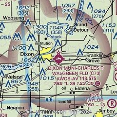
| Sectional chart |
|---|
|
| Airport distance calculator |
|---|
|
|
| Sunrise and sunset |
|---|
|
Times for 25-May-2025
| | Local
(UTC-5) | | Zulu
(UTC) |
|---|
| Morning civil twilight | | 04:57 | | 09:57 |
| Sunrise | | 05:30 | | 10:30 |
| Sunset | | 20:19 | | 01:19 |
| Evening civil twilight | | 20:52 | | 01:52 |
|
| Current date and time |
|---|
| Zulu (UTC) | 25-May-2025 23:58:37 |
|---|
| Local (UTC-5) | 25-May-2025 18:58:37 |
|---|
|
| METAR |
|---|
KSQI
11nm SW | 252256Z AUTO 15006KT 10SM FEW070 19/08 A3024 RMK AO2 SLP238 T01940083 PWINO $
|
KRPJ
17nm E | 252335Z AUTO 11006KT 10SM CLR 20/03 A3024 RMK AO2 T01950031
|
|
| TAF |
|---|
KRFD
27nm NE | 251720Z 2518/2618 06011KT P6SM SCT250
|
|
| NOTAMs |
|---|
NOTAMs are issued by the DoD/FAA and will open in a separate window not controlled by AirNav.
|
|


