FAA INFORMATION EFFECTIVE 16 APRIL 2026
Location
| FAA Identifier: | E45 |
| Lat/Long: | 37-51-42.0000N 120-10-42.8000W
37-51.700000N 120-10.713333W
37.8616667,-120.1785556
(estimated) |
| Elevation: | 2932.6 ft. / 893.9 m (surveyed) |
| Variation: | 15E (1995) |
| From city: | 3 miles NE of GROVELAND, CA |
| Time zone: | UTC -7 (UTC -8 during Standard Time) |
| Zip code: | 95321 |
Airport Operations
| Airport use: | Open to the public |
| Activation date: | 02/1970 |
| Control tower: | no |
| ARTCC: | OAKLAND CENTER |
| FSS: | RANCHO MURIETA FLIGHT SERVICE STATION |
| NOTAMs facility: | RIU (NOTAM-D service available) |
| Attendance: | UNATNDD |
| Wind indicator: | lighted |
| Segmented circle: | yes |
| Lights: | ACTVT MIRL RY 09/27 - CTAF. |
| Beacon: | white-green (lighted land airport)
Operates sunset to sunrise. |
| Taxiway lights: | RWY EXIT LGTS. |
Airport Communications
| CTAF: | 122.9 |
| WX AWOS-3 at O22 (15 nm NW): | 124.65 (209-536-9384) |
- APCH/DEP CTL SVC PRVDD BY OAKLAND ARTCC (ZOA) ON FREQS 121.25/327.0 (ANGELS CAMP RCAG).
Nearby radio navigation aids
| VOR radial/distance | | VOR name | | Freq | | Var |
|---|
| MODr052/39.6 | | MODESTO VOR/DME | | 114.60 | | 17E |
| HYPr000/40.0 | | EL NIDO VOR/DME | | 113.85 | | 15E |
Airport Services
| Fuel available: | 100LL
100LL:FUEL 24 HR SELF-SERVICE. |
| Parking: | tiedowns |
| Airframe service: | NONE |
| Powerplant service: | NONE |
| Bottled oxygen: | NONE |
| Bulk oxygen: | NONE |
Runway Information
Runway 9/27
| Dimensions: | 3624 x 50 ft. / 1105 x 15 m
200 FT GRVL RY SAFETY AREA WEST END; 100 FT GRVL RY SAFETY AREA EAST END. |
| Surface: | asphalt, in good condition |
| Weight bearing capacity: | |
| Runway edge lights: | medium intensity |
| RUNWAY 9 | | RUNWAY 27 |
| Latitude: | 37-51.804412N | | 37-51.595452N |
| Longitude: | 120-11.066088W | | 120-10.360605W |
| Elevation: | 2895.1 ft. | | 2932.6 ft. |
| Traffic pattern: | left | | right |
| Runway heading: | 095 magnetic, 110 true | | 275 magnetic, 290 true |
| Markings: | nonprecision, in good condition | | nonprecision, in good condition |
| Visual slope indicator: | 2-box VASI on left (4.50 degrees glide path) | | 2-light PAPI on left (4.00 degrees glide path)
PAPI RY 27 UNUSABLE BYD 7 DEG LEFT AND RIGHT OF CENTERLINE. |
| Touchdown point: | yes, no lights | | yes, no lights |
| Obstructions: | 10 ft. trees, 420 ft. from runway, 25 ft. left of centerline, 22:1 slope to clear | | 35 ft. trees, 980 ft. from runway, 22:1 slope to clear |
Airport Ownership and Management from official FAA records
| Ownership: | Publicly-owned |
| Owner: | TULOUMNE COUNTY
2 SOUTH GREEN ST.
SONORA, CA 95370
Phone 209-533-5685 |
| Manager: | TONYA SCHEFTNER
10723 AIRPORT RD
COLUMBIA, CA 95310
Phone 209-533-5685
OFFICE AT COLUMBIA, CA ARPT. |
Additional Remarks
| - | TRANSIENT PARKING AVBL. |
| - | FEE FOR OVERNIGHT PARKING. |
| - | DEER ON & INVOF ARPT AT ALL TIMES. |
| - | FOR CD CTC OAKLAND ARTCC AT 510-745-3380. |
| - | SAYWEATHER ADZY WX SYS AVBL. NOT AN FAA AWOS. CTAF ACTIVATION: 5 CLICKS FOR RWY LGTS, 4 CLICKS FOR FULL WX, 3 CLICKS FOR WINDS. |
Instrument Procedures
NOTE: All procedures below are presented as PDF files. If you need a reader for these files, you should download the free Adobe Reader.NOT FOR NAVIGATION. Please procure official charts for flight.
FAA instrument procedures published for use from 16 April 2026 at 0901Z to 14 May 2026 at 0900Z.
IAPs - Instrument Approach Procedures |
|---|
| RNAV (GPS) RWY 09 | |
download (222KB) |
| GPS RWY 27 | |
download (291KB) |
| NOTE: Special Take-Off Minimums/Departure Procedures apply | |
download (189KB) |
Other nearby airports with instrument procedures:
O22 - Columbia Airport (15 nm NW)
KMPI - Mariposa-Yosemite Airport (22 nm S)
KCPU - Calaveras County Airport/Maury Rasmussen Field (28 nm NW)
O27 - Oakdale Airport (30 nm W)
O15 - Turlock Municipal Airport (33 nm SW)
|
|

Road maps at:
MapQuest
Bing
Google
| Aerial photo |
|---|
WARNING: Photo may not be current or correct
 Photo taken 17-Apr-2011
looking southeast.
Photo taken 17-Apr-2011
looking southeast.
Do you have a better or more recent aerial photo of Groveland/Yosemite Airport that you would like to share? If so, please send us your photo.
|
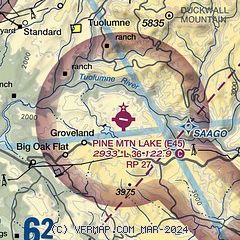
| Sectional chart |
|---|
|
| Airport distance calculator |
|---|
|
|
| Sunrise and sunset |
|---|
|
Times for 11-May-2026
| | Local
(UTC-7) | | Zulu
(UTC) |
|---|
| Morning civil twilight | | 05:26 | | 12:26 |
| Sunrise | | 05:55 | | 12:55 |
| Sunset | | 19:59 | | 02:59 |
| Evening civil twilight | | 20:28 | | 03:28 |
|
| Current date and time |
|---|
| Zulu (UTC) | 12-May-2026 00:32:07 |
|---|
| Local (UTC-7) | 11-May-2026 17:32:07 |
|---|
|
| METAR |
|---|
KO22
15nm NW | 112355Z AUTO VRB04KT 10SM CLR 31/12 A2996 RMK A01
|
KCPU
28nm NW | 120015Z AUTO 31007KT 10SM CLR 32/11 A2992 RMK AO2 T03170106
|
|
| TAF |
|---|
KMER
34nm SW | 111720Z 1118/1218 VRB05KT P6SM SKC FM120300 26009KT P6SM SKC FM120800 VRB04KT P6SM SKC AMD NOT SKED
|
KMCE
38nm SW | 111720Z 1118/1218 VRB05KT P6SM SKC FM120300 26009KT P6SM SKC FM120800 VRB04KT P6SM SKC
|
KMOD
39nm W | 111724Z 1118/1218 33008KT P6SM BKN250
|
|
| NOTAMs |
|---|
NOTAMs are issued by the DoD/FAA and will open in a separate window not controlled by AirNav.
|
|

