FAA INFORMATION EFFECTIVE 17 APRIL 2025
Location
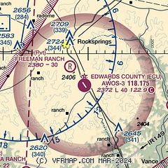
| FAA Identifier: | ECU |
| Lat/Long: | 29-56-48.9105N 100-10-25.8768W
29-56.815175N 100-10.431280W
29.9469196,-100.1738547
(estimated) |
| Elevation: | 2372.2 ft. / 723.0 m (surveyed) |
| Variation: | 07E (2000) |
| From city: | 4 miles SE of ROCKSPRINGS, TX |
| Time zone: | UTC -5 (UTC -6 during Standard Time) |
| Zip code: | 78880 |
Airport Operations
| Airport use: | Open to the public |
| Activation date: | 02/1977 |
| Control tower: | no |
| ARTCC: | HOUSTON CENTER |
| FSS: | SAN ANGELO FLIGHT SERVICE STATION |
| NOTAMs facility: | ECU (NOTAM-D service available) |
| Attendance: | UNATNDD |
| Wind indicator: | yes |
| Segmented circle: | yes |
| Lights: | SS-SR |
| Beacon: | white-green (lighted land airport)
Operates sunset to sunrise. |
Airport Communications
| CTAF: | 122.9 |
| WX AWOS-3: | 118.175 (830-683-2425) |
| DEL RIO APPROACH: | 119.6 |
| DEL RIO DEPARTURE: | 119.6 |
- APCH/DEP CTL SVC PRVDD BY HOUSTON ARTCC (ZHU) ON FREQS 125.75/346.4 (ROCK SPRINGS RCAG) WHEN DEL RIO APCH CTL (DLF) CLSD.
Nearby radio navigation aids
| VOR radial/distance | | VOR name | | Freq | | Var |
|---|
| RSGr112/7.7 | | ROCKSPRINGS VORTAC | | 114.55 | | 10E |
Airport Services
| Parking: | tiedowns |
| Airframe service: | NONE |
| Powerplant service: | NONE |
Runway Information
Runway 14/32
| Dimensions: | 4050 x 50 ft. / 1234 x 15 m |
| Surface: | asphalt, in fair condition |
| Weight bearing capacity: | |
| Runway edge lights: | medium intensity |
| Runway edge markings: | MRKGS FADED. |
| RUNWAY 14 | | RUNWAY 32 |
| Latitude: | 29-57.089513N | | 29-56.540830N |
| Longitude: | 100-10.650122W | | 100-10.212458W |
| Elevation: | 2367.1 ft. | | 2368.7 ft. |
| Traffic pattern: | left | | left |
| Runway heading: | 138 magnetic, 145 true | | 318 magnetic, 325 true |
| Displaced threshold: | 278 ft.
NGT OPN DSPLCD THR LGTS ARE 288 FT FM RWY END. | | no |
| Markings: | nonprecision, in poor condition | | basic, in poor condition |
| Touchdown point: | yes, no lights | | yes, no lights |
| Obstructions: | 25 ft. trees, 201 ft. from runway
8 FT MKD FENCE, 30 FT DSTC. | | 23 ft. trees, 780 ft. from runway, 200 ft. right of centerline, 25:1 slope to clear |
Airport Ownership and Management from official FAA records
| Ownership: | Publicly-owned |
| Owner: | COUNTY OF EDWARDS
EDWARDS CTY COURTHOUSE, 100 WEST MAIN
ROCKSPRINGS, TX 78880
Phone 830-683-6122 |
| Manager: | JASON ARP
, BOX 348
ROCKSPRINGS, TX 78880
Phone 830-683-7193
ROAD AND BRIDGE SUPT. |
Additional Remarks
| - | GATE ACES USE FLD ELEV. |
| - | FOR CD CTC LAUGHLIN APCH AT 830-298-5192, WHEN APCH CLSD CTC HOUSTON ARTCC AT 281-230-5622. |
| - | GRAVEL PIT ADJ TO RWY W SIDE, 12 FT DIRT PILES 156 FT FM RWY CL. |
Instrument Procedures
NOTE: All procedures below are presented as PDF files. If you need a reader for these files, you should download the free Adobe Reader.NOT FOR NAVIGATION. Please procure official charts for flight.
FAA instrument procedures published for use from 17 April 2025 at 0901Z to 15 May 2025 at 0900z.
IAPs - Instrument Approach Procedures |
|---|
| RNAV (GPS) RWY 14 | |
download (200KB) |
| VOR RWY 14 | |
download (241KB) |
| NOTE: Special Alternate Minimums apply | |
download (13KB) |
| NOTE: Special Take-Off Minimums/Departure Procedures apply | |
download (105KB) |
Other nearby airports with instrument procedures:
KJCT - Kimble County Airport (40 nm NE)
KSOA - Sonora Municipal Airport (46 nm NW)
KDLF - Laughlin AFB Airport (47 nm SW)
KUVA - Garner Field Airport (50 nm SE)
KDRT - Del Rio International Airport (52 nm SW)
|
|

Road maps at:
MapQuest
Bing
Google
| Aerial photo |
|---|
WARNING: Photo may not be current or correct
 Photo by Bruce D. Sidlinger
Photo taken 16-Jul-2006
Photo by Bruce D. Sidlinger
Photo taken 16-Jul-2006
Do you have a better or more recent aerial photo of Edwards County Airport that you would like to share? If so, please send us your photo.
|
| Sectional chart |
|---|
|
| Airport distance calculator |
|---|
|
|
| Sunrise and sunset |
|---|
|
Times for 20-Apr-2025
| | Local
(UTC-5) | | Zulu
(UTC) |
|---|
| Morning civil twilight | | 06:45 | | 11:45 |
| Sunrise | | 07:10 | | 12:10 |
| Sunset | | 20:10 | | 01:10 |
| Evening civil twilight | | 20:35 | | 01:35 |
|
| Current date and time |
|---|
| Zulu (UTC) | 21-Apr-2025 04:57:58 |
|---|
| Local (UTC-5) | 20-Apr-2025 23:57:58 |
|---|
|
| METAR |
|---|
| KECU | 210435Z AUTO 07005KT 10SM BKN060 18/03 A3012 RMK AO2
|
|
| TAF |
|---|
KJCT
39nm NE | 201738Z 2018/2118 28013G23KT P6SM SKC FM202300 VRB05KT P6SM SKC
|
KSOA
46nm NW | 201738Z 2018/2118 28013G20KT P6SM SKC FM210000 VRB04KT P6SM SKC FM211600 15007KT P6SM SKC
|
KDLF
47nm SW | 202200Z 2022/2124 35009KT 9999 SKC QNH2994INS BECMG 2102/2103 VRB06KT 9999 SKC QNH2988INS WND 13009KT AFT 2113 TX30/2023Z TN14/2112Z LAST NO AMDS AFT 2022 NEXT 2110
|
|
| NOTAMs |
|---|
NOTAMs are issued by the DoD/FAA and will open in a separate window not controlled by AirNav.
|
|


