FAA INFORMATION EFFECTIVE 11 JUNE 2026
Location
| FAA Identifier: | SOA |
| Lat/Long: | 30-35-08.5000N 100-38-54.8000W
30-35.141667N 100-38.913333W
30.5856944,-100.6485556
(estimated) |
| Elevation: | 2139.9 ft. / 652.2 m (surveyed) |
| Variation: | 08E (1995) |
| From city: | 1 mile N of SONORA, TX |
| Time zone: | UTC -5 (UTC -6 during Standard Time) |
| Zip code: | 76950 |
Airport Operations
| Airport use: | Open to the public |
| Activation date: | 08/1958 |
| Control tower: | no |
| ARTCC: | HOUSTON CENTER |
| FSS: | SAN ANGELO FLIGHT SERVICE STATION |
| NOTAMs facility: | SOA (NOTAM-D service available) |
| Attendance: | UNATNDD |
| Wind indicator: | lighted |
| Segmented circle: | no |
| Lights: | NSTD SOLAR LIGHTS RWY 18/36 DUSK- DAWN. ACTVT REIL RWY 18 & 36; PVASI RWY 18 & 36 - CTAF. |
| Beacon: | white-green (lighted land airport)
Operates sunset to sunrise. |
Airport Communications
| CTAF/UNICOM: | 122.8 |
| WX AWOS-3: | 118.075 (325-387-3801) |
| WX AWOS-3 at 9TE2 (11 nm E): | 120.425 (325-276-2771) |
- APCH/DEP CTL SVC PRVDD BY HOUSTON ARTCC ON FREQS 125.75/346.4 (ROCK SPRINGS RCAG).
Nearby radio navigation aids
| VOR radial/distance | | VOR name | | Freq | | Var |
|---|
| RSGr322/38.7 | | ROCKSPRINGS VORTAC | | 114.55 | | 10E |
| NDB name | | Hdg/Dist | | Freq | | Var | | ID |
|---|
| SONORA | | at field | | 371 | | 08E | | SOA | ... --- .- |
Airport Services
| Parking: | tiedowns |
| Airframe service: | NONE |
| Powerplant service: | NONE |
| Bottled oxygen: | NONE |
| Bulk oxygen: | NONE |
Runway Information
Runway 18/36
| Dimensions: | 4037 x 60 ft. / 1230 x 18 m |
| Surface: | asphalt, in fair condition |
| Weight bearing capacity: | |
| Runway edge lights: | medium intensity
SOLAR LIGHTS |
| Runway edge markings: | MRKGS FADED. |
| RUNWAY 18 | | RUNWAY 36 |
| Latitude: | 30-35.469805N | | 30-34.814092N |
| Longitude: | 100-38.846922W | | 100-38.981115W |
| Elevation: | 2139.2 ft. | | 2135.3 ft. |
| Traffic pattern: | left | | left |
| Runway heading: | 182 magnetic, 190 true | | 002 magnetic, 010 true |
| Displaced threshold: | 93 ft. | | 601 ft. |
| Markings: | nonprecision, in poor condition | | basic, in poor condition |
| Visual slope indicator: | pulsating/steady burning VASI on left (3.00 degrees glide path) | | pulsating/steady burning VASI on left (3.00 degrees glide path) |
| Runway end identifier lights: | yes | | yes |
| Touchdown point: | yes, no lights | | yes, no lights |
| Obstructions: | 40 ft. trees, 564 ft. from runway, 105 ft. left of centerline, 9:1 slope to clear
6-15 FT FENCE 0 FT DSTC ACRS APCH, 15 FT BRUSH, 0-25 FT DSTC. | | 50 ft. pline, 200 ft. from runway, 239 ft. left of centerline
8 FT FENCE 90 DSTC 0 FT B; 25 FT RD 122 FT DSTC 0B; 50 FT POLE 32 FT DSTC 233 FT L, 28 FT TREE, 0 FT DSTC, 153 FT R. |
Airport Ownership and Management from official FAA records
| Ownership: | Publicly-owned |
| Owner: | CITY OF SONORA
201 E MAIN ST
SONORA, TX 76950
Phone 325-387-2558 |
| Manager: | PETER R DURAN
201 E MAIN ST
SONORA, TX 76950
Phone 325-387-2558
AMGR CELL: 325-206-4712 |
Additional Remarks
| - | FOR CD CTC HOUSTON ARTCC AT 281-230-5622. |
Instrument Procedures
NOTE: All procedures below are presented as PDF files. If you need a reader for these files, you should download the free Adobe Reader.NOT FOR NAVIGATION. Please procure official charts for flight.
FAA instrument procedures published for use from 11 June 2026 at 0901Z to 09 July 2026 at 0900z.
IAPs - Instrument Approach Procedures |
|---|
| RNAV (GPS) RWY 18 | |
download (205KB) |
| NOTE: Special Alternate Minimums apply | |
download (138KB) |
| NOTE: Special Take-Off Minimums/Departure Procedures apply | |
download (311KB) |
Other nearby airports with instrument procedures:
KOZA - Ozona Municipal Airport (30 nm W)
KECU - Edwards County Airport (46 nm SE)
KJCT - Kimble County Airport (46 nm E)
KSJT - San Angelo Regional Airport/Mathis Field (47 nm N)
E41 - Reagan County Airport (56 nm NW)
|
|

Road maps at:
MapQuest
Bing
Google
| Aerial photo |
|---|
WARNING: Photo may not be current or correct

Do you have a better or more recent aerial photo of Sonora Municipal Airport that you would like to share? If so, please send us your photo.
|
| Sectional chart |
|---|
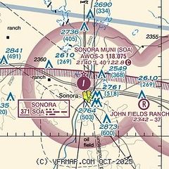
|
| Airport distance calculator |
|---|
|
|
| Sunrise and sunset |
|---|
|
Times for 17-Jun-2026
| | Local
(UTC-5) | | Zulu
(UTC) |
|---|
| Morning civil twilight | | 06:13 | | 11:13 |
| Sunrise | | 06:41 | | 11:41 |
| Sunset | | 20:46 | | 01:46 |
| Evening civil twilight | | 21:14 | | 02:14 |
|
| Current date and time |
|---|
| Zulu (UTC) | 18-Jun-2026 02:42:22 |
|---|
| Local (UTC-5) | 17-Jun-2026 21:42:22 |
|---|
|
| METAR |
|---|
| KSOA | 180215Z AUTO 16007KT 10SM CLR 31/20 A2969 RMK AO2
|
|
| TAF |
|---|
| KSOA | 171720Z 1718/1818 18010KT P6SM FEW250
|
|
| NOTAMs |
|---|
NOTAMs are issued by the DoD/FAA and will open in a separate window not controlled by AirNav.
|
|


