FAA INFORMATION EFFECTIVE 19 FEBRUARY 2026
Location
| FAA Identifier: | SJT |
| Lat/Long: | 31-21-27.8940N 100-29-46.6950W
31-21.464900N 100-29.778250W
31.3577483,-100.4963042
(estimated) |
| Elevation: | 1918.6 ft. / 584.8 m (surveyed) |
| Variation: | 05E (2020) |
| From city: | 7 miles SW of SAN ANGELO, TX |
| Time zone: | UTC -6 (UTC -5 during Daylight Saving Time) |
| Zip code: | 76904 |
Airport Operations
| Airport use: | Open to the public |
| Activation date: | 09/1943 |
| Control tower: | yes |
| ARTCC: | FORT WORTH CENTER |
| FSS: | SAN ANGELO FLIGHT SERVICE STATION |
| NOTAMs facility: | SJT (NOTAM-D service available) |
| Attendance: | 0600-2200 |
| Wind indicator: | lighted |
| Segmented circle: | yes |
| Lights: | DUSK-DAWN. WHEN ATCT CLSD MIRL RWY 18/36 PRESET LOW INTST. TO INCR INTST & ACTVT MALSR RWY 03; REIL RWY 18; PAPI RWYS 18 & 36; HIRL RWY 03/21; MIRL RWY 09/27 - CTAF. |
| Beacon: | white-green (lighted land airport)
Operates sunset to sunrise. |
| Landing fee: | yes |
| Fire and rescue: | ARFF index B |
| Airline operations: | PPR 12 HRS FOR UNSKED ACR OPNS WITH OVER 30 PSGR SEATS CALL AMGR 325-659-6409. |
Airport Communications
| CTAF: | 118.3 |
| UNICOM: | 122.95 |
| ATIS: | 128.45 319.0 |
| WX ASOS: | 128.45 (325-255-3637) |
| MATHIS GROUND: | 121.9 348.6 [0700-2100] |
| MATHIS TOWER: | 118.3 284.7 [0700-2100] |
| SAN ANGELO APPROACH: | 125.35 |
| SAN ANGELO DEPARTURE: | 125.35 |
| EMERG: | 121.5 243.0 |
- APCH/DEP CTL SVC PRVDD BY FORT WORTH ARTCC (ZFW) ON FREQS 126.15/322.55 (SAN ANGELO RCAG) WHEN MIDLAND APCH CTL (MAF) CLSD.
Nearby radio navigation aids
| VOR radial/distance | | VOR name | | Freq | | Var |
|---|
| SJTr234/2.4 | | SAN ANGELO VORTAC | | 115.10 | | 10E |
| NDB name | | Hdg/Dist | | Freq | | Var | | ID |
|---|
| WOOLE | | 036/6.2 | | 356 | | 05E | | SJ | ... .--- |
Airport Services
| Fuel available: | 100LL JET-A
100LL:FEE FOR FUEL AFT HRS CALL 325-656-1836/1837. |
| Parking: | hangars and tiedowns |
| Airframe service: | MAJOR |
| Powerplant service: | MAJOR |
| Bottled oxygen: | LOW |
| Bulk oxygen: | HIGH/LOW |
Runway Information
Runway 18/36
| Dimensions: | 8054 x 150 ft. / 2455 x 46 m |
| Surface: | asphalt/grooved, in good condition |
| Weight bearing capacity: | | Single wheel: | 70.0 | | Double wheel: | 100.0 |
|
| Runway edge lights: | medium intensity |
| RUNWAY 18 | | RUNWAY 36 |
| Latitude: | 31-22.127290N | | 31-20.809765N |
| Longitude: | 100-29.850692W | | 100-30.047687W |
| Elevation: | 1896.9 ft. | | 1918.6 ft. |
| Traffic pattern: | left | | left |
| Runway heading: | 182 magnetic, 187 true | | 002 magnetic, 007 true |
| Displaced threshold: | 902 ft. | | no |
| Declared distances: | TORA:8054 TODA:8054 ASDA:8054 LDA:7152 | | TORA:7152 TODA:7152 ASDA:7152 LDA:7152 |
| Markings: | nonprecision, in good condition | | nonprecision, in good condition |
| Visual slope indicator: | 4-light PAPI on left (3.00 degrees glide path) | | 4-light PAPI on left (3.00 degrees glide path) |
| Runway end identifier lights: | yes | | |
| Touchdown point: | yes, no lights | | yes, no lights |
| Obstructions: | 6 ft. road, 380 ft. from runway, 270 ft. right of centerline, 30:1 slope to clear
APCH RATIO 50+:1 TO DSPLCD THR. | | none |
Runway 3/21
| Dimensions: | 5940 x 150 ft. / 1811 x 46 m |
| Surface: | asphalt/grooved, in fair condition |
| Weight bearing capacity: | | Single wheel: | 70.0 | | Double wheel: | 100.0 |
|
| Runway edge lights: | high intensity |
| RUNWAY 3 | | RUNWAY 21 |
| Latitude: | 31-20.982188N | | 31-21.696845N |
| Longitude: | 100-29.992063W | | 100-29.211267W |
| Elevation: | 1916.4 ft. | | 1893.0 ft. |
| Traffic pattern: | left | | left |
| Runway heading: | 038 magnetic, 043 true | | 218 magnetic, 223 true |
| Declared distances: | TORA:5940 TODA:5940 ASDA:5940 LDA:5940 | | TORA:5940 TODA:5940 ASDA:5940 LDA:5940 |
| Markings: | precision, in good condition | | precision, in good condition |
| Visual slope indicator: | | | 4-box VASI on left (3.00 degrees glide path) |
| RVR equipment: | touchdown | | rollout |
| Approach lights: | MALSR: 1,400 foot medium intensity approach lighting system with runway alignment indicator lights | | |
| Runway end identifier lights: | | | no |
| Touchdown point: | yes, no lights | | yes, no lights |
| Instrument approach: | ILS/DME | | |
Runway 9/27
| Dimensions: | 4406 x 75 ft. / 1343 x 23 m |
| Surface: | asphalt, in poor condition
RWY SLATED FOR CLOSURE |
| Weight bearing capacity: | | Single wheel: | 70.0 | | Double wheel: | 100.0 |
|
| Runway edge lights: | medium intensity |
| RUNWAY 9 | | RUNWAY 27 |
| Latitude: | 31-21.674548N | | 31-21.579895N |
| Longitude: | 100-30.123630W | | 100-29.283960W |
| Elevation: | 1902.3 ft. | | 1898.4 ft. |
| Traffic pattern: | left | | left |
| Runway heading: | 092 magnetic, 097 true | | 272 magnetic, 277 true |
| Declared distances: | TORA:4406 TODA:4406 ASDA:4406 LDA:4406 | | TORA:4406 TODA:4406 ASDA:4406 LDA:4406 |
| Markings: | basic, in good condition | | basic, in good condition |
| Touchdown point: | yes, no lights | | yes, no lights |
| Obstructions: | 13 ft. road, 529 ft. from runway, 25:1 slope to clear | | 12 ft. road, 633 ft. from runway, 36:1 slope to clear |
Airport Ownership and Management from official FAA records
| Ownership: | Publicly-owned |
| Owner: | CITY OF SAN ANGELO
72 W COLLEGE ST
SAN ANGELO, TX 76903
Phone 325-659-6409 |
| Manager: | JUSTIN FLETCHER
8618 TERMINAL DRIVE, SUITE 101
SAN ANGELO, TX 76904
Phone 325-659-6409 |
Additional Remarks
| A39-18/36 | PCR VALUE: 490/F/C/X/T |
| A39-09/27 | PCR VALUE: 170/F/C/X/T |
| A39-03/21 | PCR VALUE: 450/F/B/X/T |
| - | FOR CD IF UNA TO CTC ON FSS FREQ, CTC FORT WORTH ARTCC AT 817-858-7584. |
Instrument Procedures
NOTE: All procedures below are presented as PDF files. If you need a reader for these files, you should download the free Adobe Reader.NOT FOR NAVIGATION. Please procure official charts for flight.
FAA instrument procedures published for use from 19 February 2026 at 0901Z to 19 March 2026 at 0900Z.
IAPs - Instrument Approach Procedures |
|---|
| ILS Y OR LOC Y RWY 03 | |
download (334KB) |
| RNAV (GPS) RWY 03 | |
download (261KB) |
| RNAV (GPS) RWY 18 | |
download (268KB) |
| RNAV (GPS) RWY 21 | |
download (247KB) |
| RNAV (GPS) RWY 36 | |
download (233KB) |
| VOR Y OR TACAN Y RWY 03 | |
download (233KB) |
| VOR Y OR TACAN Y RWY 03 | |
download (233KB) |
| VOR Y RWY 21 | |
download (218KB) |
| HI-VOR Z OR TACAN RWY 21 | |
download (127KB) |
| NDB RWY 03 | |
download (211KB) |
| NOTE: Special Alternate Minimums apply | |
download (139KB) |
| NOTE: Special Take-Off Minimums/Departure Procedures apply | |
download (303KB) |
Other nearby airports with instrument procedures:
E30 - Bruce Field Airport (33 nm NE)
77F - Winters Municipal Airport (44 nm NE)
KSOA - Sonora Municipal Airport (47 nm S)
E41 - Reagan County Airport (51 nm W)
KOZA - Ozona Municipal Airport (52 nm SW)
|
|

Road maps at:
MapQuest
Bing
Google
| Aerial photo |
|---|
WARNING: Photo may not be current or correct
 Photo by Tammy Smith
Photo taken 17-Feb-2014
looking southeast.
Photo by Tammy Smith
Photo taken 17-Feb-2014
looking southeast.
Do you have a better or more recent aerial photo of San Angelo Regional Airport/Mathis Field that you would like to share? If so, please send us your photo.
|
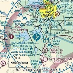
| Sectional chart |
|---|
|
CAUTION: Diagram may not be current
 Download PDF
of official airport diagram from the FAA
| Airport distance calculator |
|---|
|
|
| Sunrise and sunset |
|---|
|
Times for 02-Mar-2026
| | Local
(UTC-6) | | Zulu
(UTC) |
|---|
| Morning civil twilight | | 06:44 | | 12:44 |
| Sunrise | | 07:09 | | 13:09 |
| Sunset | | 18:40 | | 00:40 |
| Evening civil twilight | | 19:04 | | 01:04 |
|
| Current date and time |
|---|
| Zulu (UTC) | 03-Mar-2026 00:21:39 |
|---|
| Local (UTC-6) | 02-Mar-2026 18:21:39 |
|---|
|
| METAR |
|---|
| KSJT | 022351Z 19011G18KT 10SM CLR 27/14 A2992 RMK AO2 SLP115 T02720139 10283 20194 56017
|
|
| TAF |
|---|
| KSJT | 021938Z 0220/0318 17009KT P6SM SKC FM030900 17010KT P6SM BKN015 FM031500 17015G25KT P6SM SCT015
|
|
| NOTAMs |
|---|
NOTAMs are issued by the DoD/FAA and will open in a separate window not controlled by AirNav.
|
|


