FAA INFORMATION EFFECTIVE 14 MAY 2026
Location
| FAA Identifier: | OZA |
| Lat/Long: | 30-44-06.7000N 101-12-07.9000W
30-44.111667N 101-12.131667W
30.7351944,-101.2021944
(estimated) |
| Elevation: | 2376.9 ft. / 724.5 m (surveyed) |
| Variation: | 08E (1985) |
| From city: | 1 mile N of OZONA, TX |
| Time zone: | UTC -5 (UTC -6 during Standard Time) |
| Zip code: | 76943 |
Airport Operations
| Airport use: | Open to the public |
| Activation date: | 12/1950 |
| Control tower: | no |
| ARTCC: | HOUSTON CENTER |
| FSS: | SAN ANGELO FLIGHT SERVICE STATION |
| NOTAMs facility: | SJT (NOTAM-D service available) |
| Attendance: | MON-FRI 0800-1700 |
| Wind indicator: | lighted |
| Segmented circle: | yes |
| Lights: | RWY 16/34 MIRL PRESET MED INTST; TO INCR INTST ACTVT - CTAF. |
| Beacon: | white-green (lighted land airport)
Operates sunset to sunrise. |
Airport Communications
| CTAF/UNICOM: | 122.8 |
| WX AWOS-3PT: | 118.425 (325-392-2051) |
- APCH/DEP CTL SVC PRVDD BY HOUSTON ARTCC ON FREQS 125.75/346.4 (ROCK SPRINGS RCAG).
Nearby radio navigation aids
| NDB name | | Hdg/Dist | | Freq | | Var | | ID |
|---|
| SONORA | | 280/30.1 | | 371 | | 08E | | SOA | ... --- .- |
Airport Services
| Fuel available: | 100LL JET-A
100LL:FOR AFT HRS FUEL CALL 325-226-2628. |
| Parking: | tiedowns |
Runway Information
Runway 16/34
| Dimensions: | 6003 x 75 ft. / 1830 x 23 m |
| Surface: | asphalt, in good condition |
| Weight bearing capacity: | |
| Runway edge lights: | medium intensity |
| RUNWAY 16 | | RUNWAY 34 |
| Latitude: | 30-44.595668N | | 30-43.628147N |
| Longitude: | 101-12.252547W | | 101-12.009455W |
| Elevation: | 2376.8 ft. | | 2355.3 ft. |
| Traffic pattern: | left | | left |
| Runway heading: | 160 magnetic, 168 true | | 340 magnetic, 348 true |
| Markings: | nonprecision, in good condition | | nonprecision, in good condition |
| Visual slope indicator: | 4-light PAPI on left (3.00 degrees glide path) | | 4-light PAPI on left (3.00 degrees glide path) |
| Touchdown point: | yes, no lights | | yes, no lights |
| Obstructions: | 40 ft. trees, 830 ft. from runway, 350 ft. right of centerline, 15:1 slope to clear | | 50 ft. pole, 1200 ft. from runway, 45 ft. right of centerline, 20:1 slope to clear |
Airport Ownership and Management from official FAA records
| Ownership: | Publicly-owned |
| Owner: | CROCKETT COUNTY
PO BOX 1857 COUNTY COURTHOUSE
OZONA, TX 76943
Phone 325-392-2965 |
| Manager: | CHARLES MCCLEARY
BOX 426
OZONA, TX 76943
Phone 325-392-2030
ARPT PHYS ADDRESS 319 CR 308. |
Additional Remarks
| - | FOR CD CTC HOUSTON ARTCC AT 281-230-5622. |
Instrument Procedures
NOTE: All procedures below are presented as PDF files. If you need a reader for these files, you should download the free Adobe Reader.NOT FOR NAVIGATION. Please procure official charts for flight.
FAA instrument procedures published for use from 14 May 2026 at 0901Z to 11 June 2026 at 0900Z.
IAPs - Instrument Approach Procedures |
|---|
| RNAV (GPS) RWY 16 | |
download (226KB) |
| NOTE: Special Take-Off Minimums/Departure Procedures apply | |
download (105KB) |
Other nearby airports with instrument procedures:
KSOA - Sonora Municipal Airport (30 nm E)
E41 - Reagan County Airport (31 nm NW)
KSJT - San Angelo Regional Airport/Mathis Field (52 nm NE)
KECU - Edwards County Airport (71 nm SE)
KJCT - Kimble County Airport (76 nm E)
|
|

Road maps at:
MapQuest
Bing
Google
| Aerial photo |
|---|
WARNING: Photo may not be current or correct
 Photo taken 29-Jul-2011
looking southwest.
Photo taken 29-Jul-2011
looking southwest.
Do you have a better or more recent aerial photo of Ozona Municipal Airport that you would like to share? If so, please send us your photo.
|
| Sectional chart |
|---|
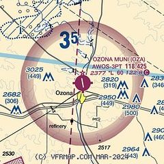
|
| Airport distance calculator |
|---|
|
|
| Sunrise and sunset |
|---|
|
Times for 22-May-2026
| | Local
(UTC-5) | | Zulu
(UTC) |
|---|
| Morning civil twilight | | 06:20 | | 11:20 |
| Sunrise | | 06:47 | | 11:47 |
| Sunset | | 20:36 | | 01:36 |
| Evening civil twilight | | 21:03 | | 02:03 |
|
| Current date and time |
|---|
| Zulu (UTC) | 22-May-2026 11:08:21 |
|---|
| Local (UTC-5) | 22-May-2026 06:08:21 |
|---|
|
| METAR |
|---|
| KOZA | 221055Z AUTO 00000KT 10SM BKN015 14/13 A2991 RMK AO2
|
|
| TAF |
|---|
KSOA
30nm E | 220520Z 2206/2306 VRB03KT P6SM SCT007 BKN250 TEMPO 2206/2210 3SM BR BKN007 FM221000 18003KT 3SM BR BKN007 TEMPO 2210/2214 P6SM NSW SCT007 FM221400 19007KT P6SM SCT250 FM221800 20010KT P6SM FEW060 AMD NOT SKED
|
|
| NOTAMs |
|---|
NOTAMs are issued by the DoD/FAA and will open in a separate window not controlled by AirNav.
|
|


