FAA INFORMATION EFFECTIVE 19 FEBRUARY 2026
Location
| FAA Identifier: | I16 |
| Lat/Long: | 37-36-01.6000N 081-33-33.4000W
37-36.026667N 081-33.556667W
37.6004444,-81.5592778
(estimated) |
| Elevation: | 1783 ft. / 543.5 m (surveyed) |
| Variation: | 05W (1985) |
| From city: | 2 miles NW of PINEVILLE, WV |
| Time zone: | UTC -5 (UTC -4 during Daylight Saving Time) |
| Zip code: | 24874 |
Airport Operations
| Airport use: | Open to the public |
| Activation date: | 10/1969 |
| Control tower: | no |
| ARTCC: | INDIANAPOLIS CENTER |
| FSS: | ELKINS FLIGHT SERVICE STATION [703-724-4288] |
| NOTAMs facility: | EKN (NOTAM-D service available) |
| Attendance: | MON-FRI 0900-1600
UNATND MAJ. HOL. FOR ARPT ATTENDANT AFTER HRS CALL 304-732-7372 (MGR RES). |
| Wind indicator: | lighted |
| Segmented circle: | yes |
| Lights: | ACTVT MIRL RY 08/26, REIL RYS 08/26 - CTAF. |
| Beacon: | white-green (lighted land airport)
ARPT BCN LCTD 3000' NE ARPT. Operates sunset to sunrise. |
Airport Communications
| CTAF/UNICOM: | 122.8 |
| WX AWOS-3: | 120.625 (304-732-7311) |
| CHARLESTON APPROACH: | 125.4 |
| CHARLESTON DEPARTURE: | 125.4 |
Nearby radio navigation aids
| VOR radial/distance | | VOR name | | Freq | | Var |
|---|
| BLFr318/24.8 | | BLUEFIELD VOR/DME | | 115.05 | | 03W |
Airport Services
| Fuel available: | 100LL |
| Parking: | hangars and tiedowns |
Runway Information
Runway 8/26
| Dimensions: | 3701 x 60 ft. / 1128 x 18 m |
| Surface: | asphalt, in good condition |
| Weight bearing capacity: | |
| Runway edge lights: | medium intensity |
| RUNWAY 8 | | RUNWAY 26 |
| Latitude: | 37-35.920750N | | 37-36.133983N |
| Longitude: | 081-33.915000W | | 081-33.197033W |
| Elevation: | 1724.5 ft. | | 1783.0 ft. |
| Traffic pattern: | left | | left |
| Runway heading: | 074 magnetic, 069 true | | 254 magnetic, 249 true |
| Displaced threshold: | no | | 590 ft. |
| Markings: | nonprecision, in good condition | | nonprecision, in good condition |
| Runway end identifier lights: | yes | | yes |
| Touchdown point: | yes, no lights | | yes, no lights |
| Obstructions: | 80 ft. trees, 201 ft. from runway, 120 ft. right of centerline
25 FT GND UP TO 200 FT OUT, 120 FT LEFT; 40 FT TREES 0 FT DSTC, 120 FT RIGHT. | | 50 ft. trees, 201 ft. from runway, 220 ft. right of centerline
RISING GND 4 FT, 75 TO 200 FT DSTC, ACROSS THLD. 30 FT TREES, 0 FT DSTC, 7 FT LEFT & RIGHT. |
Airport Ownership and Management from official FAA records
| Ownership: | Publicly-owned |
| Owner: | WYOMING CO COMM.
COURTHOUSE
PINEVILLE, WV 24874
Phone 304-732-8000 |
| Manager: | BILLY JOE COOPER
PO BOX 309
PINEVILLE, WV 24874
Phone 304-732-9160 |
Additional Remarks
| - | WILDLIFE ON AND INVOF ARPT. |
| - | LANDFILL MIDPT OF RWY, SOUTH SIDE. BIRDS ON AND INVOF ARPT. |
| - | RISING TERRAIN SURROUNDS ARPT. |
| - | RY SLOPES DOWN 2% FROM E TO W. |
| - | FOR CD CTC INDIANAPOLIS ARTCC AT 317-247-2411. |
Instrument Procedures
NOTE: All procedures below are presented as PDF files. If you need a reader for these files, you should download the free Adobe Reader.NOT FOR NAVIGATION. Please procure official charts for flight.
FAA instrument procedures published for use from 19 February 2026 at 0901Z to 19 March 2026 at 0900Z.
IAPs - Instrument Approach Procedures |
|---|
| RNAV (GPS) RWY 08 | |
download (178KB) |
| RNAV (GPS) RWY 26 | |
download (194KB) |
| NOTE: Special Alternate Minimums apply | |
download (147KB) |
| NOTE: Special Alternate Minimums apply | |
download (147KB) |
| NOTE: Special Take-Off Minimums/Departure Procedures apply | |
download (428KB) |
Other nearby airports with instrument procedures:
6L4 - Logan County Airport (23 nm NW)
KBKW - Raleigh County Memorial Airport (24 nm NE)
KBLF - Mercer County Airport (25 nm SE)
KEBD - Southern West Virginia Regional Airport (27 nm W)
KJFZ - Tazewell County Airport (34 nm S)
|
|

Road maps at:
MapQuest
Bing
Google
| Aerial photo |
|---|
WARNING: Photo may not be current or correct

Do you have a better or more recent aerial photo of Kee Field Airport that you would like to share? If so, please send us your photo.
|
| Sectional chart |
|---|
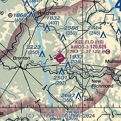
|
| Airport distance calculator |
|---|
|
|
| Sunrise and sunset |
|---|
|
Times for 05-Mar-2026
| | Local
(UTC-5) | | Zulu
(UTC) |
|---|
| Morning civil twilight | | 06:27 | | 11:27 |
| Sunrise | | 06:53 | | 11:53 |
| Sunset | | 18:23 | | 23:23 |
| Evening civil twilight | | 18:49 | | 23:49 |
|
| Current date and time |
|---|
| Zulu (UTC) | 05-Mar-2026 11:02:46 |
|---|
| Local (UTC-5) | 05-Mar-2026 06:02:46 |
|---|
|
| METAR |
|---|
| KI16 | 051055Z AUTO 7SM BKN070 08/08 A3020 RMK AO2 T00820082
|
|
| TAF |
|---|
KBKW
24nm NE | 050520Z 0506/0606 20005KT P6SM BKN080 FM051500 23008G18KT P6SM SCT100 FM060000 22007KT P6SM SCT090 TEMPO 0600/0603 P6SM -SHRA OVC100 FM060300 22006KT P6SM BKN090
|
KBLF
25nm SE | 050520Z 0506/0606 19004KT P6SM BKN250 FM051700 24009G19KT P6SM BKN250 FM060500 24005KT P6SM BKN150
|
|
| NOTAMs |
|---|
NOTAMs are issued by the DoD/FAA and will open in a separate window not controlled by AirNav.
|
|

