FAA INFORMATION EFFECTIVE 14 MAY 2026
Location
| FAA Identifier: | BKW |
| Lat/Long: | 37-47-14.4000N 081-07-27.0000W
37-47.240000N 081-07.450000W
37.7873333,-81.1241667
(estimated) |
| Elevation: | 2503.8 ft. / 763.2 m (surveyed) |
| Variation: | 06W (1985) |
| From city: | 3 miles E of BECKLEY, WV |
| Time zone: | UTC -4 (UTC -5 during Standard Time) |
| Zip code: | 25813 |
Airport Operations
| Airport use: | Open to the public |
| Activation date: | 09/1952 |
| Control tower: | no |
| ARTCC: | INDIANAPOLIS CENTER |
| FSS: | ELKINS FLIGHT SERVICE STATION [703-724-4288] |
| NOTAMs facility: | BKW (NOTAM-D service available) |
| Attendance: | CONTINUOUS |
| Wind indicator: | lighted |
| Segmented circle: | no |
| Lights: | ACTVT MALSR RWY 19; REIL RWY 01, 10 & 28; VASI RWY 10 & 28; MIRL RWY 10/28; HIRL RWY 01/19; TWY LGTS - CTAF. PAPI RWY 01 & 19 SET AT MEDIUM, CTC UNICOM TO CHANGE INTST. |
| Beacon: | white-green (lighted land airport)
Operates sunset to sunrise. |
| Fire and rescue: | ARFF index B |
| Airline operations: | PPR 24 HRS FOR UNSKED ACR OPNS WITH MORE THAN 30 PSGR SEATS; CALL AMGR 304-255-0476. INDEX B COVERAGE IS PRVDD. |
Airport Communications
| CTAF/UNICOM: | 123.0 |
| WX ASOS: | 121.55 (304-362-0292) |
| CHARLESTON APPROACH: | 125.4 |
| CHARLESTON DEPARTURE: | 125.4 |
Nearby radio navigation aids
| VOR radial/distance | | VOR name | | Freq | | Var |
|---|
| BLFr010/29.0 | | BLUEFIELD VOR/DME | | 115.05 | | 03W |
Airport Services
| Fuel available: | 100LL JET-A |
| Parking: | hangars and tiedowns |
| Airframe service: | MAJOR |
| Powerplant service: | MAJOR |
| Bottled oxygen: | NONE |
| Bulk oxygen: | NONE |
Runway Information
Runway 1/19
| Dimensions: | 6750 x 150 ft. / 2057 x 46 m |
| Surface: | asphalt/grooved, in good condition |
| Weight bearing capacity: | | Single wheel: | 75.0 | | Double wheel: | 150.0 | | Double tandem: | 200.0 |
|
| Runway edge lights: | high intensity |
| RUNWAY 1 | | RUNWAY 19 |
| Latitude: | 37-46.923992N | | 37-48.026512N |
| Longitude: | 081-07.546703W | | 081-07.364023W |
| Elevation: | 2495.3 ft. | | 2448.8 ft. |
| Traffic pattern: | left | | left |
| Runway heading: | 013 magnetic, 007 true | | 193 magnetic, 187 true |
| Declared distances: | TORA:6750 TODA:6750 ASDA:6750 LDA:6750 | | TORA:6750 TODA:6750 ASDA:6750 LDA:6750 |
| Markings: | nonprecision, in good condition | | precision, in good condition |
| Visual slope indicator: | 4-light PAPI on left (3.00 degrees glide path) | | 4-light PAPI on left (3.00 degrees glide path) |
| Approach lights: | | | MALSR: 1,400 foot medium intensity approach lighting system with runway alignment indicator lights |
| Runway end identifier lights: | yes | | |
| Touchdown point: | yes, no lights | | yes, no lights |
| Instrument approach: | | | ILS |
Runway 10/28
| Dimensions: | 5001 x 100 ft. / 1524 x 30 m |
| Surface: | asphalt, in good condition |
| Weight bearing capacity: | | Single wheel: | 45.0 | | Double wheel: | 60.0 |
|
| Runway edge lights: | medium intensity |
| RUNWAY 10 | | RUNWAY 28 |
| Latitude: | 37-46.975225N | | 37-46.867502N |
| Longitude: | 081-07.957047W | | 081-06.927940W |
| Elevation: | 2485.7 ft. | | 2500.8 ft. |
| Traffic pattern: | left | | left |
| Runway heading: | 104 magnetic, 098 true | | 284 magnetic, 278 true |
| Declared distances: | TORA:5001 TODA:5001 ASDA:5001 LDA:5001 | | TORA:5001 TODA:5001 ASDA:5001 LDA:5001 |
| Markings: | nonprecision, in good condition | | nonprecision, in good condition |
| Visual slope indicator: | 4-box VASI on right (3.00 degrees glide path) | | 4-box VASI on left (3.75 degrees glide path) |
| Runway end identifier lights: | yes | | yes |
| Touchdown point: | yes, no lights | | yes, no lights |
Airport Ownership and Management from official FAA records
| Ownership: | Publicly-owned |
| Owner: | RALEIGH COUNTY ARPT AUTH
176 AIRPORT CIRCLE RM 105
BEAVER, WV 25813
Phone 304-255-0476 |
| Manager: | BOB RUNION
176 AIRPORT CIRCLE RM 105
BEAVER, WV 25813
Phone 304-255-0476 |
Additional Remarks
| A39-01/19 | PCR VALUE: 740/F/B/X/T |
| A39-10/28 | PCR VALUE: 160/F/B/X/T |
| A58-28 | 9 FT OBSTN LGTD POLE, 125 FT FM AER, 250 FT R. |
| - | DEER; BIRDS & WILD TURKEYS ON & INVOF ARPT. |
| - | ALL SFCS WORK IN PROG, GRASS CUTTING APR THRU OCT. |
Instrument Procedures
NOTE: All procedures below are presented as PDF files. If you need a reader for these files, you should download the free Adobe Reader.NOT FOR NAVIGATION. Please procure official charts for flight.
FAA instrument procedures published for use from 14 May 2026 at 0901Z to 11 June 2026 at 0900Z.
IAPs - Instrument Approach Procedures |
|---|
| ILS OR LOC RWY 19 **CHANGED** | |
download (219KB) |
| RNAV (GPS) RWY 01 **CHANGED** | |
download (262KB) |
| RNAV (GPS) RWY 10 **CHANGED** | |
download (242KB) |
| RNAV (GPS) RWY 19 **CHANGED** | |
download (233KB) |
| RNAV (GPS) RWY 28 **CHANGED** | |
download (249KB) |
| NOTE: Special Alternate Minimums apply | |
download (147KB) |
| NOTE: Special Take-Off Minimums/Departure Procedures apply **CHANGED** | |
download (445KB) |
Other nearby airports with instrument procedures:
I16 - Kee Field Airport (24 nm SW)
KSXL - Summersville Airport (29 nm NE)
KBLF - Mercer County Airport (30 nm S)
KLWB - Greenbrier Valley Airport (35 nm E)
6L4 - Logan County Airport (38 nm W)
|
|

Road maps at:
MapQuest
Bing
Google
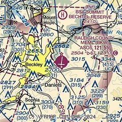
| Sectional chart |
|---|
|
| Airport distance calculator |
|---|
|
|
| Sunrise and sunset |
|---|
|
Times for 23-May-2026
| | Local
(UTC-4) | | Zulu
(UTC) |
|---|
| Morning civil twilight | | 05:40 | | 09:40 |
| Sunrise | | 06:10 | | 10:10 |
| Sunset | | 20:33 | | 00:33 |
| Evening civil twilight | | 21:03 | | 01:03 |
|
| Current date and time |
|---|
| Zulu (UTC) | 23-May-2026 14:34:52 |
|---|
| Local (UTC-4) | 23-May-2026 10:34:52 |
|---|
|
| METAR |
|---|
| KBKW | 231414Z AUTO 14011G20KT 10SM BKN010 BKN090 15/12 A3021 RMK AO2 T01500117
|
|
| TAF |
|---|
| KBKW | 231159Z 2312/2412 13012G23KT P6SM OVC006 TEMPO 2314/2318 BKN008 FM231800 14012G22KT P6SM BKN011 FM240200 14011G17KT P6SM BKN008 FM240500 15009KT P6SM BKN011 FM240800 15005KT 5SM BR SCT003 SCT015
|
|
| NOTAMs |
|---|
NOTAMs are issued by the DoD/FAA and will open in a separate window not controlled by AirNav.
|
|

