FAA INFORMATION EFFECTIVE 27 NOVEMBER 2025
Location
| FAA Identifier: | K61 |
| Lat/Long: | 39-28-20.5000N 098-07-42.0220W
39-28.341667N 098-07.700367W
39.4723611,-98.1283394
(estimated) |
| Elevation: | 1418.4 ft. / 432.3 m (surveyed) |
| Variation: | 05E (2010) |
| From city: | 1 mile NW of BELOIT, KS |
| Time zone: | UTC -6 (UTC -5 during Daylight Saving Time) |
| Zip code: | 67420 |
Airport Operations
| Airport use: | Open to the public |
| Activation date: | 01/1942 |
| Control tower: | no |
| ARTCC: | KANSAS CITY CENTER |
| FSS: | WICHITA FLIGHT SERVICE STATION |
| NOTAMs facility: | ICT (NOTAM-D service available) |
| Attendance: | MON-SAT 0800-1800 |
| Wind indicator: | lighted |
| Segmented circle: | yes |
| Lights: | ACTVT MIRL 17/35; PAPI RWY 17 & 35 - CTAF. |
| Beacon: | white-green (lighted land airport)
Operates sunset to sunrise. |
Airport Communications
| CTAF/UNICOM: | 122.8 |
| WX AWOS-3PT: | 118.225 (785-378-4173) |
- APCH/DEP CTL SVC PRVDD BY KANSAS CITY ARTCC (ZKC) ON FREQS 134.9/363.2 (SALINA RCAG).
Airport Services
| Fuel available: | 100LL JET-A |
| Parking: | hangars and tiedowns |
| Airframe service: | MAJOR |
| Powerplant service: | MAJOR |
Runway Information
Runway 17/35
| Dimensions: | 4200 x 75 ft. / 1280 x 23 m |
| Surface: | concrete, in excellent condition |
| Weight bearing capacity: | | PCN 11 /R/C/X/U | | Single wheel: | 30.0 | | Double wheel: | 30.0 |
|
| Runway edge lights: | medium intensity |
| RUNWAY 17 | | RUNWAY 35 |
| Latitude: | 39-28.766110N | | 39-28.074622N |
| Longitude: | 098-07.625325W | | 098-07.608673W |
| Elevation: | 1417.8 ft. | | 1416.0 ft. |
| Traffic pattern: | left | | left |
| Runway heading: | 174 magnetic, 179 true | | 354 magnetic, 359 true |
| Displaced threshold: | 181 ft. | | no |
| Declared distances: | TORA:4200 TODA:4200 ASDA:4200 LDA:4018 | | TORA:4200 TODA:4200 ASDA:4200 LDA:4200 |
| Markings: | nonprecision, in good condition | | nonprecision, in good condition |
| Visual slope indicator: | 2-light PAPI on left (4.00 degrees glide path) | | 2-light PAPI on left (3.00 degrees glide path) |
| Touchdown point: | yes, no lights | | yes, no lights |
| Obstructions: | 15 ft. road, 610 ft. from runway, 27:1 slope to clear | | 40 ft. pole, 330 ft. from runway, 245 ft. right of centerline, 3:1 slope to clear
25 FT DIRT MOUND 86 FT FM RWY END. |
Runway 4/22
| Dimensions: | 2340 x 120 ft. / 713 x 37 m |
| Surface: | turf, in fair condition |
| Runway edge markings: | RED & WHITE L MKRS WITH REFLECTOR RAISED PANELS. |
| RUNWAY 4 | | RUNWAY 22 |
| Latitude: | 39-28.062453N | | 39-28.338500N |
| Longitude: | 098-08.023537W | | 098-07.676333W |
| Elevation: | 1408.4 ft. | | 1411.2 ft. |
| Traffic pattern: | left | | left |
| Runway heading: | 039 magnetic, 044 true | | 219 magnetic, 224 true |
| Markings: | NSTD, in fair condition | | NSTD, in fair condition |
| Touchdown point: | yes, no lights | | yes, no lights |
| Obstructions: | 35 ft. pole, 310 ft. from runway, 50 ft. left of centerline, 8:1 slope to clear | | none |
Airport Ownership and Management from official FAA records
| Ownership: | Publicly-owned |
| Owner: | CITY OF BELOIT
MUNICIPAL BLDG
BELOIT, KS 67420
Phone 785-738-3551 |
| Manager: | TRAVIS LATTIN FBO
MORITZ MEMORIAL ARPT RR 3
BELOIT, KS 67420
Phone 785-738-7437 |
Additional Remarks
| - | GLIDER OPS ON ARPT. RDO CTL OPS ON & INVOF ARPT; WKEND & HOL. |
| - | FOR CD CTC KANSAS CITY ARTCC AT 913-254-8508. |
| - | FUEL AVBL H24 WITH CREDIT CARD; SVC AFT HR - AMGR. |
Instrument Procedures
NOTE: All procedures below are presented as PDF files. If you need a reader for these files, you should download the free Adobe Reader.NOT FOR NAVIGATION. Please procure official charts for flight.
FAA instrument procedures published for use from 27 November 2025 at 0901Z to 25 December 2025 at 0900Z.
IAPs - Instrument Approach Procedures |
|---|
| RNAV (GPS) RWY 17 | |
download (228KB) |
| RNAV (GPS) RWY 35 | |
download (204KB) |
| NOTE: Special Take-Off Minimums/Departure Procedures apply | |
download (374KB) |
Other nearby airports with instrument procedures:
KCNK - Blosser Municipal Airport (23 nm E)
KRPB - Belleville Municipal Airport (30 nm NE)
12K - Superior Municipal Airport (35 nm N)
K82 - Smith Center Municipal Airport (35 nm NW)
7V7 - Red Cloud Municipal Airport (41 nm NW)
|
|

Road maps at:
MapQuest
Bing
Google
| Aerial photo |
|---|
WARNING: Photo may not be current or correct
 Photo taken 24-Jun-2006
Do you have a better or more recent aerial photo of Moritz Memorial Airport that you would like to share? If so, please send us your photo.
|
| Sectional chart |
|---|
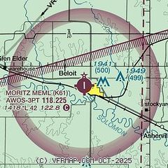
|
| Airport distance calculator |
|---|
|
|
| Sunrise and sunset |
|---|
|
Times for 23-Dec-2025
| | Local
(UTC-6) | | Zulu
(UTC) |
|---|
| Morning civil twilight | | 07:21 | | 13:21 |
| Sunrise | | 07:51 | | 13:51 |
| Sunset | | 17:12 | | 23:12 |
| Evening civil twilight | | 17:42 | | 23:42 |
|
| Current date and time |
|---|
| Zulu (UTC) | 23-Dec-2025 21:34:03 |
|---|
| Local (UTC-6) | 23-Dec-2025 15:34:03 |
|---|
|
| METAR |
|---|
KCNK
23nm E | 232055Z AUTO 10SM CLR 17/02 A3010 RMK AO2 SLP194 T01720022 56013 $
|
|
| TAF |
|---|
KSLN
47nm SE | 231724Z 2318/2418 05009KT P6SM FEW250 FM240600 15005KT 2SM BR SCT003 BKN020 FM241500 19008KT 4SM BR BKN020
|
KRSL
48nm SW | 231724Z 2318/2418 06011KT P6SM FEW250 FM240900 18007KT 4SM BR FEW003 SCT100 FM241500 21009KT P6SM SCT100
|
|
| NOTAMs |
|---|
NOTAMs are issued by the DoD/FAA and will open in a separate window not controlled by AirNav.
|
|

